Similar Sale History
View More Items in Maps & Atlases


Item Details
Description
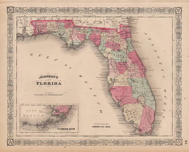
Vivid hand coloring makes this Civil War era map really stand out. The map, created in 1860, was used for several years in subsequent editions of Mitchell’s New General Atlas. This one is dated 1860 and is from Mitchell Jr’s 1864 edition of his New General Atlas. Railroad lines, which were the principal highways in those days, are depicted rather prominently. Shows vast swamplands and numerous forts in southern portion of Florida, as well as many forts. Fort Moultrie located in South Carolina. Fort Johnson, Fort Macon and Fort Clark are located in North Carolina. Many coastal details, such as inlets, bays, islands, keys, etc. An interesting map featuring Mitchell’s signature and distinctive border which sets Mitchell maps apart from most other map producers of the period. Mitchell maps are sought after for their fine engraving, bright coloring, and attention to detail. They are considered some of the finest maps produced during this era. A clean, presentable map with lovely hand-coloring. 11.5 x 14
Reserve: $65.00
Shipping:Domestic: Flat-rate of $5.00 to anywhere within the contiguous U.S. International: Foreign shipping rates are determined by destination. International shipping may be subject to VAT. Combined shipping: Please ask about combined shipping for multiple lots before bidding. Location: This item ships from Ohio
Your purchase is protected:
Photos, descriptions, and estimates were prepared with the utmost care by a fully certified expert and appraiser. All items in this sale are guaranteed authentic.
In the rare event that the item did not conform to the lot description in the sale, Jasper52 specialists are here to help. Buyers may return the item for a full refund provided you notify Jasper52 within 5 days of receiving the item.
Reserve: $65.00
Shipping:
Your purchase is protected:
Photos, descriptions, and estimates were prepared with the utmost care by a fully certified expert and appraiser. All items in this sale are guaranteed authentic.
In the rare event that the item did not conform to the lot description in the sale, Jasper52 specialists are here to help. Buyers may return the item for a full refund provided you notify Jasper52 within 5 days of receiving the item.
Condition
Very good plus
Buyer's Premium
- 15%
County map of Florida with the Carolinas during Civil War, 1864
$65.00
$115
3 bidders are watching this item.
Shipping & Pickup Options
Item located in Ohio, US$5 shipping in the US
Payment
Accepts seamless payments through LiveAuctioneers
See More Items From This Jasper52 Seller

Related Maps & Atlases
More Items in Maps & Atlases
View MoreRecommended Transportation & Travel Collectibles
View MoreRelated Searches
TOP


![The finest and largest map of Long Island of the period: [MAP-NEW YORK] MATHER, W.W. Geological Map of Long & Staten Islands with the Environs of New York. [New York: 1842]. Hand-colored lithographed map on two sheets joined from the topographical surve](https://p1.liveauctioneers.com/292/326828/175962867_1_x.jpg?height=310&quality=70&version=1713473479)


