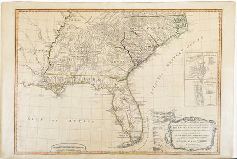
Laurie & Whittle Map of the British Colonies of North America
Similar Sale History
View More Items in Maps & AtlasesRelated Maps & Atlases
More Items in Maps & Atlases
View MoreRecommended Transportation & Travel Collectibles
View More


Item Details
Description
LAURIE, Robert (1755-1836), and WHITTLE, James (1757-1818).
A New and Correct Map of the British Colonies in North America comprehending Eastern Canada...with the adjacent states of New England.
Engraved map with original hand color in full.
London: Laurie and Whittle, 1794.
20 1/2" x 28 3/4" sheet, 29 1/2" x 38" framed.
Detailed map including eastern Canada with Quebec, New Brunswick, Nova Scotia, and Newfoundland together with New England, New York, New Jersey and parts of Pennsylvania, Maryland and Delaware. The great fishing banks are graphically depicted. There are numerous interesting notations throughout, e.g., "This vast Tract of Land, which is the Ancient Couchsachrage one of the Four Beaver-Hunting Countries of the Six Nations, is not yet Surveyed" and "Col. Arnold's Rout [sic] in 1775" referring to Benedict Arnold's winter campaign at the start of the American Revolution. The title cartouche is surmounted by a beaver.
Buyer's Premium
- 25%
Laurie & Whittle Map of the British Colonies of North America
Estimate $3,000 - $5,000
2 bidders are watching this item.
Shipping & Pickup Options
Item located in New York, NY, usOffers In-House Shipping
Local Pickup Available
Payment
Accepts seamless payments through LiveAuctioneers

Related Searches
TOP


![Mitchell Map of the British and French Dominions of North America, 1755 - VERY RARE FIRST EDITION,: MITCHELL, John (1711-1768). A Map of the British and French Dominions of North America. Engraved map in 8 sheets. Published [London:] Publish'd by the Author Feb.ry 13th. 1755, and Sold by And: Miller](https://p1.liveauctioneers.com/1968/282833/149849101_1_x.jpg?height=310&quality=70&version=1680275215)


![Map of Virginia, Carolinas and Georgia from Marshall's Life of Washington: [Marshall's Life of Washington]. Map of part of Virginia North Carolina South Carolina & Georgia which were the scenes of the most important Operations of the Southern Armies. Engraved map, by J. Yeag](https://p1.liveauctioneers.com/1968/322135/173185711_1_x.jpg?height=310&quality=70&version=1709997984)

![Map of New York from Marshall's Life of Washington: [Marshall's Life of Washington]. Plan of New York Island and part of Long Island Shewing the Position of the American & British Armies before, at, and after the Engagement on the Heights August 27th 1](https://p1.liveauctioneers.com/1968/322135/173185714_1_x.jpg?height=310&quality=70&version=1711031437)
![Map of New York Marshall's Life of Washington: [Marshall's Life of Washington]. Plan of the Country from Frogs Point to Croton River Shewing the Positions of the American & British Armies from the 12th of Oct. 1776 until the Engagement of the Whit](https://p1.liveauctioneers.com/1968/322135/173185715_1_x.jpg?height=310&quality=70&version=1709997984)


![Bernard / Miller Manuscript Map of the Great Eastern: [Map - Colonial New England] [BERNARD, Sir Francis, Governor of Colonial Massachusetts (1712-1779) & Francis MILLER, Surveyor (1733-1800). Untitled Manuscript Road Map of "The Great Eastern Road." [Ro](https://p1.liveauctioneers.com/1968/225974/116712071_1_x.jpg?height=310&quality=70&version=1636655147)


![1761 NEW DICTIONARY OF TRADE & COMMERCE R. ROLT antique FOLIO ILLUSTRATED w/MAPS: A New Dictionary of Trade and Commerce... The Second edition [preface by Samuel Johnson] With the Addition of a New and Accurate Set of Maps... by Mr. Bowen. London: 1761 by Richard ROLT. Folio: 9.5 b](https://p1.liveauctioneers.com/5584/327967/176717236_1_x.jpg?height=310&quality=70&version=1714507672)


![[Maps] Gio. Ant. Magnini, Italia, 1620: [Maps] Gio. Ant. Magnini, Italia, 1620, Giovanni Antonio Magnini. Italia, data in luce da Fabio suo figliuolo al Serenissimo Ferdinado Gonzaga Duca di Matoua edi Monserrato etc. Bologna, for Sebastian](https://p1.liveauctioneers.com/188/326797/176317457_1_x.jpg?height=310&quality=70&version=1713847031)


