


Eliot Map of the Revolutionary War naming the United States, 4th State
Similar Sale History
View More Items in Maps & Atlases


Related Maps & Atlases


![Rand, McNally & Co.'S New Commercial Railroad Map of the United States [Chicago to Denver]: Title: Rand, McNally & Co.'S New Commercial Railroad Map of the United States [Chicago to Denver] Cartographer: RAND, MCNALLY & CO. Publisher: RAND-MCNALLY & CO. Dimensions: Height: 26 Width: 18.5 Des](https://p1.liveauctioneers.com/5584/329422/177662153_1_x.jpg?height=310&quality=70&version=1715717898)


More Items in American Revolutionary Period Maps & Atlases
View More
![[MAP]. SARTINE, Antoine Plan de la Barre et du Havre de Charles-Town...1778. RARE REVOLUTIONARY WAR: [MAP]. SARTINE, Antoine (1729-1801). Plan de la Barre et du Havre de Charles-Town d'apres un plan Anglois leve en 1776... Paris: Depot de la Marine for M. de Sartine, 1778. Copperplate engraving, matt](https://p1.liveauctioneers.com/197/329395/177650540_1_x.jpg?height=310&quality=70&version=1715364962)
Recommended Transportation & Travel Collectibles
View More


Item Details
Description
ELIOT, Jean Baptiste (18th Century); MONDHARE, Joseph (fl. c. 1750 - 1790).
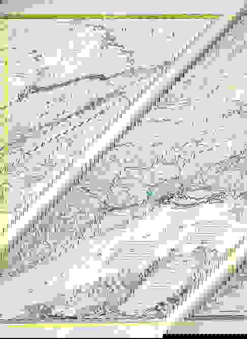
Carte du Theatre de la Guerre actuel entre les Anglais et les Trieze Colonies Unies de l'Amerique Septentrionale dresse par J.B. Eliot Aide de Camp du General Washington ou se trouvent les Principaux Camps et les Epoques des Combats qui se sont donnes dans cette partie de l'Amerique 1781.
Engraved Map with color in outline.
Paris: 1781 [Fourth State].
27 1/2" x 21 1/2" sheet; 36 3/4" x 28" framed.
The First Map to Name The United States
Fine example of J. B. Eliot's map of the United States, the first state of which is generally regarded as the earliest map to include the title "United States'' on a printed map, with additional annotations in a contemporary hand.
The present example is the second state of the map, with details of the battles fought during the American Revolution from the "Affaire de Bunker hill 17, Juin", 1775 to the "Camp du General Washington" in 1781, with a manuscript additions below it noting the "Surrender of L. Cornwallis 19 Cot. at York river."
Eliot's map, which was drawn from American sources not previously utilized on any printed map, is generally regarded as the first printed map to bear the name of the United States (''Etats Unis''). The map translates from the French as "Map of the Actual Seat of War between the English and the Thirteen Colonies' of North America, as described by J.B. Eliot, an 'Engineer of the United States '." As noted by Ristow:
A highlight of 1778 was the French declaration of alliance with the Americans on May 4. This led immediately to French mapping of the American War of Independence, and that year "Carte de Theatre de la Guerre actuel entre les Anglais et les trieze Colonies Unies de l'Amerique Septentrionale" (Plate 122) by J.B. Eliot, an American Engineer, was published in Paris. It is the earliest known map to include the name "United States. . . ."
In an excellent essay on the map by Margaret Pritchard and Henry Taliaferro ( Degrees of Latitude, Map 58), the importance of the map and Eliot, its mysterious maker are discussed at greater length.
The MAP of the theater of war between Great Britain and America by J.B. Eliot is important because of its title, les Trieze Colonies Unies de l'Amerique Septentrionale, may include the first reference on a map to the United States. The cartographer was identified as Ingenieurs des Etats Unis. On November 15, 1777, the Continental Congress selected "The United States of America," as the name of the thirteen colonies that formed a government under the Articles of Confederation. One month later, French authorities learned of the victory at Saratoga and decided to recognize American independence. By January 8, French foreign minister, Charles Gravier, Comte de Vergennes, informed American envoys that France was ready to engage in an alliance. It is not surprising that the name United States was first mentioned on a map published in Paris in 1778.
Although the second state [actually fourth] of the map referred to Eliot as an aide-de-campe to General Washington, no references to him have been located in the Washington papers. It is also curious that he did not indicate on the map the General's 1777 winter headquarters at Valley Forge, misspelled Walay Forge. What Eliot did illustrate were the lines of march taken by the British and American forces during the campaign in 1777, including Lieutenant Colonel Barry St. Ledger's unsuccessful diversionary expedition down the Mohawk Valley, Burgoyne's march from Crown Point to Albany, and Howe's campaign to take Philadelphia.
As was usually the case, Eliot appears to have borrowed from several sources in compiling the geography. Some areas were designated by French place-names while others are predominantly English, specifically in the northwestern territories that the French knew best. It is clear they were aware of the latest intelligence relating to the Revolutionary War.
In the second state [actually fourth] of the map, Eliot's title is changed from "Ingenieurs des Etats Unis " to "Aide de Camp du General Washington." While Ristow speculated that J.B. Eliot may have been a liaison between General Washington and France, there is no record of any military officer of this name serving in such capacity in the Department des Cartes et Plans in the Bibliotheque Nationale de France.
One of the most curious elements of the map is the spelling of the name "Walay Forge." George Washington first arrived at Valley Forge on December 19, 1777 and maintained it as his headquarters until June 19, 1778. On the First-State of the Eliot-Mondhare map, the name appears as "Walay Forge", with no further explanation. It is curious that any reference to this location would appear on the map at all, as it was generally not considered to be a place important enough to make it onto a small-scale map until it was made famous by the war. The misspelling suggests that the map was published relatively shortly after the news of the battle reached Paris, as the misspelling could not have lasted long.
The news of the location of Valley Forge (and indeed an appreciation of its importance) likely reached Paris in the late spring of 1778. Mondhare may well have added it to the plate in haste without fully understanding its significance. Curiously, it is placed on the wrong side of the Schuykill River, an error corrected on this second state of the map.
It is curious that both the map also refers to Saratoga as "Saharatoga", a misspelling that also used on Brion de La Tour's map of the Theater of War and in the separate portraits of Gen. Horatio Gates published by Mondhare and Esnauts & Rapilly (both Paris, 1778). This error is repeated in the state of the map.
The present map also refers "Royal Block House," as "Royal Blanck [or Blanek] House," a curious error for this important military feature on the shores of Lake Oneida, New York. A similar error appears on Brion De La Tour's map, which uses the name "Royal Black House" - clearly done by someone who has a limited understanding of English
The present example of the map is the second state [actually fourth] of the map, which includes a slightly revised title and significant additions, primarily in New Jersey and Pennsylvania, in the area around Valley Forge and Trenton.
References: Pritchard and Taliaferro, Degrees of Latitude, #58. Schwartz and Ehrenberg, The Mapping of America, plate 122; Phillips, Maps of America, 859; McCorkle (New England in Early Printed Maps) 781.6 (first issue illustrated), and Seller and Van Ee 735.
Buyer's Premium
- 25%
Eliot Map of the Revolutionary War naming the United States, 4th State
Estimate $30,000 - $50,000
2 bidders are watching this item.
Get approved to bid.
Shipping & Pickup Options
Item located in New York, NY, usOffers In-House Shipping
Local Pickup Available
Payment
Accepts seamless payments through LiveAuctioneers

Related Searches
TOP