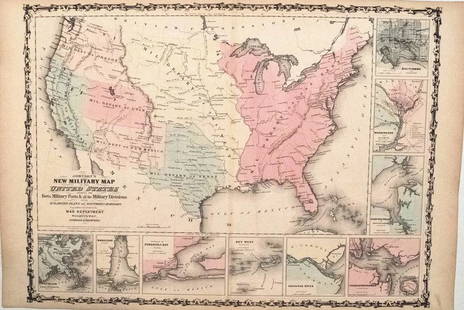
JOHN TALLIS (1817-1876) AN AMERICAN CIVIL WAR MAP, "United States," LONDON, CIRCA 1863,
Similar Sale History
View More Items in Maps & AtlasesRelated Maps & Atlases
More Items in American Maps & Atlases
View MoreRecommended Transportation & Travel Collectibles
View More


Item Details
Description
JOHN TALLIS (1817-1876) AN AMERICAN CIVIL WAR MAP, "United States," LONDON, CIRCA 1863, hand-colored lithograph on wove paper showing, "Federal, Non Slave Holding States (Red); Border, Slaveholding (Blue); Confederate (Yellow); Indian Reservation (Green);" scale in English Miles, engraver attributed to John Rapkin (1813-1899), in margin, "The London Printing and Publishing Company Limited." 11 3/4" x 18 5/8"
Condition
Some stains, tape repairs and tears, foxing, creases. Simpson Galleries strongly encourages in-person inspection of items by the bidder. Statements by Simpson Galleries regarding the condition of objects are for guidance only and should not be relied upon as statements of fact and do not constitute a representation, warranty, or assumption of liability by Simpson Galleries. All lots offered are sold "AS IS.”
Buyer's Premium
- 27%
JOHN TALLIS (1817-1876) AN AMERICAN CIVIL WAR MAP, "United States," LONDON, CIRCA 1863,
Estimate $100 - $200
11 bidders are watching this item.
Shipping & Pickup Options
Item located in Houston, TX, usSee Policy for Shipping
Local Pickup Available
Payment

Related Searches
TOP


![RAPKIN - New York Manhattan Map 1852: [NEW YORK CITY] - J. Rapkin. New York. London and New York: John Tallis & Co., [1852]. Engraved map by Rapkin within an ornamental border, with six engraved inset views by H. Winkles. Sheet size: 21 3](https://p1.liveauctioneers.com/7533/208644/106251124_1_x.jpg?height=310&quality=70&version=1624641782)
![Johnston Map of U.S. 1844: *** START PRICE IS THE RESERVE *** [America] JOHNSTON, Alexander Keith (1804-1871). United States and Texas. Lithograph with original color. London, 1844. 21 1/8" x 26 1/8" sheet. Comparable: Old Worl](https://p1.liveauctioneers.com/1968/163248/82424588_1_x.jpg?height=310&quality=70&version=1583340284)

![Railroad Map of the United States: [America, East Coast] Ensign, Bridgman and Fanning's Railroad Map of the United States showing the Depots & Stations. Engraved map with original hand color. Engraved by W. S. Barnard. New York, 1856.](https://p1.liveauctioneers.com/1968/203922/103366115_1_x.jpg?height=310&quality=70&version=1620913733)


![Memoir to accompany Missip.-Pacific Map: Heading: Author: Warren, Gouverneur K. Title: Memoir to Accompany the Map of the Territory of the United States from the Mississippi River to the Pacific Ocean Place Published: [Washington, D.C.] Pub](https://p1.liveauctioneers.com/642/326037/175553704_1_x.jpg?height=310&quality=70&version=1713477451)


