Johnson: Antique 1st Edition Civil War Military Map
Similar Sale History
View More Items in Maps & AtlasesRelated Maps & Atlases
More Items in American Maps & Atlases
View MoreRecommended Transportation & Travel Collectibles
View More


Item Details
Description
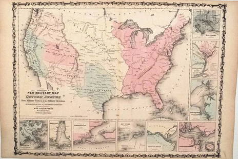
1st edition Johnson’s Civil War Military Map, Johnson & Browning. Scarce 1861 map by A. J. Johnson showing the military deportment of the United States in 1860, just before war broke out in the states. Full title is “Johnson's New Military Map of the United States showing the Forts, Military Posts & all the Military Divisions with Enlarged Plans of Southern Harbors.” Covers the entire United States which is shown divided into seven military departments. Bordered at bottom and right side by inset plans or views of Southern Harbors. Insets include Baltimore, Washington and Vicinity, Hampton Roads, Charleston Harbor, the Savannah River, Key West, Pensacola Bay, Mobile Bay, and New Orleans. Map references various changes to the military department system at the outset of the Civil War. Just before the map was made, the Department of the Pacific was sectioned into the Department of California, the Department of Oregon, and the Department of New Mexico. Within the first year of the Civil War, this primitive department structure was completely changed with numerous smaller departments ranging from the Department of the Potomac to the Department of Key West supplementing the more archaic large department system. Unlike most Johnson maps, this one is a fully independent production and was not inherited from the earlier work of Colton, nor was it included in the first edition (1860) of Johnson's Family Atlas. This example is the true first edition that appeared for the first time in the second Johnson and Browning edition, 1861. This map is exceptionally ephemeral, reflecting the changing nature of the department system itself (this example is the only issue to reflect a seven-department system). Johnson later reissued the map with various completely new plates and 18 departments through 1863, before abandoning the concept entirely in favor of a state focused presentation. Very mild toning to edges. Few very small sulfide spots. Small split at top and bottom centerfold. Several tiny edge tears repaired on reverse side with archival tape. 17 x 23.5 inches.
Please note that this lot has a confidential reserve. When you leave a bid in advance of the auction, submit your maximum. The bidder who has submitted the highest bid wins the lot, provided the bid exceeds the reserve price.
Shipping:Domestic: Flat-rate of $7.50 to anywhere within the contiguous U.S. International: Foreign shipping rates are determined by destination. Location: This item ships from Ohio
Your purchase is protected:
Photos, descriptions, and estimates were prepared with the utmost care by a fully certified expert and appraiser. All items in this sale are guaranteed authentic.
In the rare event that the item did not conform to the lot description in the sale, Jasper52 specialists are here to help. Buyers may return the item for a full refund provided you notify Jasper52 within 5 days of receiving the item.
Please note that this lot has a confidential reserve. When you leave a bid in advance of the auction, submit your maximum. The bidder who has submitted the highest bid wins the lot, provided the bid exceeds the reserve price.
Shipping:
Your purchase is protected:
Photos, descriptions, and estimates were prepared with the utmost care by a fully certified expert and appraiser. All items in this sale are guaranteed authentic.
In the rare event that the item did not conform to the lot description in the sale, Jasper52 specialists are here to help. Buyers may return the item for a full refund provided you notify Jasper52 within 5 days of receiving the item.
Condition
Very good
Buyer's Premium
- 10%
Johnson: Antique 1st Edition Civil War Military Map
Estimate $115 - $130
5 bidders are watching this item.
Shipping & Pickup Options
Item located in Ohio, USSee Policy for Shipping
Payment
See More Items From This Jasper52 Seller

Auction Curated By

Maps Expert
TOP


![Home Waters. Blockade of Germany. Minefields. 1914. First World War. 1920 map: CAPTION PRINTED BELOW PICTURE: Home Waters [Blockade of Germany] DATE PRINTED: 1920 IMAGE SIZE: Approx 61.5 x 53.5cm, 24.25 x 21 inches (Large); Please note that this is a folding map. TYPE: Antique m](https://p1.liveauctioneers.com/5584/328641/177014357_1_x.jpg?height=310&quality=70&version=1715113718)

![Gorleston Raid, November 3rd 1914. Yarmouth. First World War. 1920 old map: CAPTION PRINTED BELOW PICTURE: Gorleston Raid November 3rd 1914 [Raid of Yarmouth] DATE PRINTED: 1920 IMAGE SIZE: Approx 44.5 x 50.5cm, 17.5 x 19.75 inches (Large); Please note that this is a folding](https://p1.liveauctioneers.com/5584/328641/177014212_1_x.jpg?height=310&quality=70&version=1715113718)


![Battle of Heligoland Bight, 28th August 1914, First World War. 1920 old map: CAPTION PRINTED BELOW PICTURE: Heligoland, 28th August 1914, General Chart of the Action [Battle of Heligoland Bight] DATE PRINTED: 1920 IMAGE SIZE: Approx 55.0 x 73.5cm, 21.5 x 29 inches (Large); Ple](https://p1.liveauctioneers.com/5584/328641/177014360_1_x.jpg?height=310&quality=70&version=1715113718)


![[Maps] Gio. Ant. Magnini, Italia, 1620: [Maps] Gio. Ant. Magnini, Italia, 1620, Giovanni Antonio Magnini. Italia, data in luce da Fabio suo figliuolo al Serenissimo Ferdinado Gonzaga Duca di Matoua edi Monserrato etc. Bologna, for Sebastian](https://p1.liveauctioneers.com/188/326797/176317457_1_x.jpg?height=310&quality=70&version=1713847031)


![[Maps] Martin Zeiler, Itinerarium Italiae, 1640: [Maps] Martin Zeiler, Itinerarium Italiae, 1640, Martini Zeilleri. Itinerarium Italiae Nov-Antiquae: oder, Raiss-Beschreibung durch Italien, Matthaus Merian, Frankfurt, 40 plates, most double-page, in](https://p1.liveauctioneers.com/188/326797/176317459_1_x.jpg?height=310&quality=70&version=1713847031)

