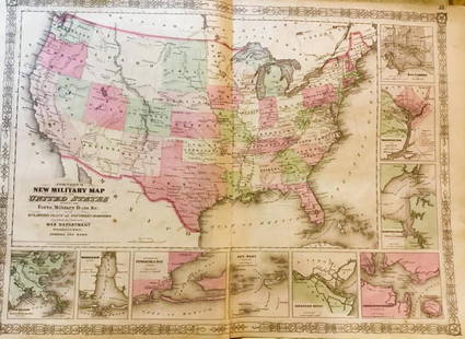
Map of the Southern States - American Civil War
Similar Sale History
View More Items in Militaria & War MemorabiliaRelated Militaria & War Memorabilia
More Items in Militaria & War Memorabilia
View MoreRecommended Collectibles
View More


Item Details
Description
Title: Map of the Southern States, Including Rail Roads, County Towns, State Capitals, County Roads, the Southern Coast from Delaware to Texas, Showing the Harbors, Inlets, Forts and Position of Blockading Ships.
Woodblock engraving, hand colored, c.1863.
Published by Harper & Brothers.
Image size 20 1/8 x 30 1/4" (51.1 x 76.8 cm).
Map including the states of Texas, Arkansas, Louisiana, Mississippi, Alabama, Florida, Georgia, Tennessee, South Carolina, North Carolina, Kentucky and Virginia. An inset map of the southern end of Florida is on the left. It shows the Everglades, Lake Okeechobee and Miami.
Text in lower reads "Prepared for Harper's History of the Rebellion, December, 1863." Interesting corner inset portraits of Lincoln, Seward, Scott and McClellan.
Condition
Condition: Good condition and color, backed on Japan paper.
Buyer's Premium
- 10%
Map of the Southern States - American Civil War
Estimate $400 - $600
8 bidders are watching this item.
Shipping & Pickup Options
Item located in New York, NY, usOffers In-House Shipping
Local Pickup Available
Payment

Related Searches
TOP


![[Civil War; Map] History of the War [1864]: Bishop, John S., Capt.: A CONCISE HISTORY OF THE WAR. DESIGNED TO ACCOMPANY PERRINE'S NEW WAR MAP OF THE SOUTHERN STATES.... Indianapolis. [1864]. 132, xi, [1] pp. plus large folding map. 5.75" x 3.75](https://p1.liveauctioneers.com/3532/91776/46880401_1_x.jpg?height=310&quality=70&version=1469669287)

![Map of the Civil War, 1863: Heading: (Civil War) Author: Perrine, Charles O. and Capt. John S. Bishop Title: Perrine's New Topographical War Map of the Southern States with a Chronology of the Great Rebellion [with] A Concise Hi](https://p1.liveauctioneers.com/642/164280/82938913_1_x.jpg?height=310&quality=70&version=1584491135)


![[WWI] P.T. Sherman's WWI Service Record & Books: The Minute Men of '17. A History of the Service Rendered During the Recent World War by the Ninth Coast Artillery Corps New York Guard and the Veteran Corps of Artillery State of New York. N.p.: Memor](https://p1.liveauctioneers.com/7226/322253/173251586_1_x.jpg?height=310&quality=70&version=1710004847)


![[CIVIL WAR] Black Soldier & Wife: CDV-sized tintype photograph WITH gem-sized tintype. Full thermoplastic case. Portrait of an unknown African American Civil War soldier who holds the rank of sergeant. He looks directly at the camera](https://p1.liveauctioneers.com/7226/322253/173251671_1_x.jpg?height=310&quality=70&version=1710004847)
![[CIVIL WAR] Black Soldier CDV: c. 1863 Carte de visite portrait of a seated Civil War African American soldier. Photographer: Edwin Allen of New Orleans, Louisiana. Wonderful portrait of a seated of African American Civil War soldi](https://p1.liveauctioneers.com/7226/322253/173251672_1_x.jpg?height=310&quality=70&version=1710004847)


![George Washington Signed Discharge: Partly printed discharge document signed by George Washington, as Commander in Chief of the Armies of the United States. Newburgh, [New York], 4 January 1783. 1 page, ## x ## in. Undersigned by Washin](https://p1.liveauctioneers.com/7226/322253/173251475_1_x.jpg?height=310&quality=70&version=1710004847)
![[Ambrotype] Texas Confederate Soldier: Sixth plate ambrotype. Full leatherette case. Portrait of a possible Texas Confederate soldier. A silver star device was used to pin up the brim of his light-toned headgear, a look often seen in image](https://p1.liveauctioneers.com/7226/322253/173251509_1_x.jpg?height=310&quality=70&version=1710004847)
![Captured Bowie Knife w/ Period Note of Provenance: Captured Confederate D-hilt Bowie knife. [Kenansville, North Carolina]: [Louis Froelich factory]. With original metal and leather sheath with affixed period notes. First note with only remnants. Secon](https://p1.liveauctioneers.com/7226/325455/175169154_1_x.jpg?height=310&quality=70&version=1712370394)

![[CIVIL WAR] 1st Texas Infantry in Camp: Outdoor half plate ambrotype of the 1st Texas Infantry. Full leatherette case. Significant, large half plate ambrotype of members of the 1st Texas Infantry at ‘Splinterville,’ the regiment’s win](https://p1.liveauctioneers.com/7226/322253/173251512_1_x.jpg?height=310&quality=70&version=1710004847)
![[HANCOCK, John] Washington’s Spy, Officer’s Commission: Partly printed document signed by John Hancock as President of the Continental Congress, for Epaphras Bull (1748-1781). [Philadelphia, Pennsylvania], 10 January 1777. 1 page, ## x ## in. Completed in](https://p1.liveauctioneers.com/7226/322253/173251471_1_x.jpg?height=310&quality=70&version=1710004847)
![[Civil War] Bullet Which Nearly Killed Soldier: Lead bullet encased in gold acorn fob with chain. Finely engraved: "W.D. Fiske / 14th Regt. C V / Fredericksburg / Dec 17, 1863." Acorn approx. 1 1/2 x 1 in. Overall length 6 1/2 in. Published in "Her](https://p1.liveauctioneers.com/7226/325455/175169103_1_x.jpg?height=310&quality=70&version=1712370394)
![Historic Einstein Signed Program from Lincoln University Visit: Conferences on Objectives. Lincoln University, [Oxford], Pennsylvania, 3 May 1946. SIGNED BY ALBERT EINSTEIN. Tipped into Horace Mann Bond (1904-1972). The Education of the Negro in the American Socia](https://p1.liveauctioneers.com/7226/322253/173251693_1_x.jpg?height=310&quality=70&version=1710004847)

![[CIVIL WAR] Captured Confederate Canteen: Wooden drum canteen with iron hardware. "C.S.A." painted in white ink/paint to side. Period ink inscribed label affixed to side reading in full: "Confederate Canteen Captured from a Confederate soldie](https://p1.liveauctioneers.com/7226/325455/175169142_1_x.jpg?height=310&quality=70&version=1712370394)


