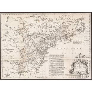
Rare map of French & Indian War theatre, 1858
Similar Sale History
View More Items in Maps & Atlases

Related Maps & Atlases
More Items in Maps & Atlases
View MoreRecommended Transportation & Travel Collectibles
View More


Item Details
Description
Heading: (French & Indian War)
Author: Anonymous
Title: A Map of that Part of America that is now the Seat of War, from Quebeck to Fort Duquesne, comprehending the English Settlement on the Sea Coast
Place Published: London
Publisher:
Date Published: 1758
Description:
Author: Anonymous
Title: A Map of that Part of America that is now the Seat of War, from Quebeck to Fort Duquesne, comprehending the English Settlement on the Sea Coast
Place Published: London
Publisher:
Date Published: 1758
Description:
Copper-engraved map. 11x19.5 cm (4¼x7¾"), hinged to mat.
Map covering the northeastern part of the United States down to Virginia, focusing on the areas of conflict in the French and Indian War. A great deal of the conflict was focused around the upper Hudson and Lake Champlain, and along the St. Laurence River. The map locates numerous forts involved in the war. This map was published in the rare Grand Magazine of Magazines in the November 1758 issue. The related article "Description of the Map of America" notes "The intelligent reader, in the course of this work, will have frequent occasion to consult this little map, which is much easier referr'd to, than map of larger dimensions." A rare map from this short-lived publication.
Condition
Mild toning, a bit of edge wear; very good.
Buyer's Premium
- 25%
Rare map of French & Indian War theatre, 1858
Estimate $300 - $500
Shipping & Pickup Options
Item located in Berkeley, CA, usSee Policy for Shipping
Payment

Related Searches
TOP


![[MAP]. SARTINE, Antoine Plan de la Barre et du Havre de Charles-Town...1778. RARE REVOLUTIONARY WAR: [MAP]. SARTINE, Antoine (1729-1801). Plan de la Barre et du Havre de Charles-Town d'apres un plan Anglois leve en 1776... Paris: Depot de la Marine for M. de Sartine, 1778. Copperplate engraving, matt](https://p1.liveauctioneers.com/197/329395/177650540_1_x.jpg?height=310&quality=70&version=1715364962)


![De Bry & Vopel Map of the Rhine River: DE BRY, Theodor de (1528-1598) after Caspar Vopel (1511–1561). [Rhine River Map] Rheni Tricornis et Vvidi Nova et Germana Descriptio, Additis Fluminibus... Engraved map. Frankfurt: T. de Bry, 1594.](https://p1.liveauctioneers.com/1968/330639/178336641_1_x.jpg?height=310&quality=70&version=1716827770)


![[MAP]. TODESCHI, Pietro. [Nova et Acurata Totius Americae Tabula auct. G.I. Blaeu] America quarta: [MAP]. TODESCHI, Pietro. [Nova et Acurata Totius Americae Tabula auct. G.I. Blaeu] America quarta pars orbis quam plerunq, nuvum orbem appellitant primo detecta est anno 1492 a Christophoro Columbo...](https://p1.liveauctioneers.com/197/329395/177650542_1_x.jpg?height=310&quality=70&version=1715364962)


![[MAPS]. HOMANN, Johann Baptist, HOMANN HEIRS, and Georg Matthäus SEUTTER. [Composite Atlas].: [MAPS]. HOMANN, Johann Baptist (1663-1724), HOMANN HEIRS, and Georg Matthäus SEUTTER (1678-1757). [Composite Atlas]. [Nuremberg, Augsburg, and others: Homann Heirs and others, maps dated between](https://p1.liveauctioneers.com/197/329395/177650530_1_x.jpg?height=310&quality=70&version=1715364962)

![[MAP]. ORTELIUS, Abraham. Americae Sive Novi Orbis, Nova Descriptio. 1573.: [MAP]. ORTELIUS, Abraham (1527-1598). Americae Sive Novi Orbis, Nova Descriptio. Antwerp, 1573. Engraved map with hand-coloring. Framed and double glazed, visible area 375 x 521 mm (unexamined out of](https://p1.liveauctioneers.com/197/329395/177650534_1_x.jpg?height=310&quality=70&version=1715364962)
![Set of Twelve Satirical Anthropomorphic Maps of Europe: [SATIRICAL MAPS] A set of twelve satirical anthropomorphic maps of Europe. London: circa 1868. A set of 12 (believed complete) lithographed maps by Vincent Brooks, Day & Son, London, each offering](https://p1.liveauctioneers.com/292/330597/178279264_1_x.jpg?height=310&quality=70&version=1716409282)


![[MAP]. ORTELIUS, Abraham. Turcici Imperii Descriptio.1592.: [MAP]. ORTELIUS, Abraham (1527-1598). Turcici Imperii Descriptio. Antwerp, 1592. Engraved map with hand-coloring. Matted, framed, and double glazed, sight 406 x 521 mm (unexamined out of frame). Decor](https://p1.liveauctioneers.com/197/329395/177650538_1_x.jpg?height=310&quality=70&version=1715364962)


![[FLAGS]. 31-star American parade flag. Ca 1850-1859.: [FLAGS]. 31-star American parade flag. Ca 1850-1859. 22 x 36 1/2 in. cotton flag with 31 printed stars, configured in a double medallion surrounding a much larger central star, that is haloed in both](https://p1.liveauctioneers.com/197/329785/177758218_1_x.jpg?height=310&quality=70&version=1715625218)


