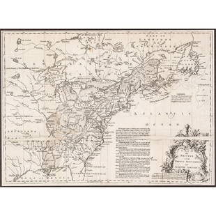
c 1760 Northern Colonies French + Indian War Map
Similar Sale History
View More Items in Maps & Atlases

Related Maps & Atlases
More Items in Maps & Atlases
View MoreRecommended Transportation & Travel Collectibles
View More


Item Details
Description
Historic Maps
Louisiana & Florida French & Indian War Era Map c. 1760
c. 1760 French & Indian War Era, Hand-Colored Map of Pennsylvania and New England titled, "Carte de la Partie Nord, Des Etats Unis, de l'Amerique Septerntrionale" by Rigobert Bonne, Extremely Fine.
This historical Map by Bonne beautifully details the land areas of Pennsylvania up through Massachusetts Bay in the early Colonial days of the United States, well before these areas became part of the Union. The Map measures 8.25" x 12.5" (plate size) and 9.75" x 14" overall. Two Sheets joined together, once bound in a book, now disbound. Sharply printed on clean, fine quality laid period paper. The paper is bright and the Hand-coloring of the various areas and borders is vibrant. Some trivial varmint damage is visible at bottom right and left outer margin selvage, most could easily be covered with a mat. Rigobert Bonne (1727"1795) was one of the most important cartographers of the late 18th century. Bonne compiled some of the most detailed and accurate maps of the period. This well detailed Map highlights Pennsylvania and some of the New England colonies. Ready for framing and display.
RIGOBERT BONNE: (1727 / 1795); one of the most important Cartographers of the late XVIII Century. In 1773 R. Bonne succeeded Jacques Nicolas Bellin as Royal Cartographer to France in the Office of the Hydrographer at the Dept de la Marine. Working in his official capacity, R. Bonne compiled some of the most detailed and accurate Maps of the Period.
Bonne's Work represents an important step in the evolution of the Cartographic Ideology away from the decorative work of the XVII and early XVIII Century towards a more detail oriented and practical aesthetic. With regard to the rendering of terrain R. Bonne maps bear many stylistic similarities to those of his predecessor, Bellin. However, Bonne maps generally abandon such common XVIII Century decorative features such as hand coloring, elaborate decorative Cartouches, and Compass Roses, etc, etc...; While mostly focusing on coastal regions, the work of RIGOBERT BONNE is highly regarded for its detail, historical importance, and overall aesthetic appeal.
Buyer's Premium
- 30%
c 1760 Northern Colonies French + Indian War Map
Estimate $600 - $800
3 bidders are watching this item.
Shipping & Pickup Options
Item located in Rancho Santa Fe, CA, usOffers In-House Shipping
Payment

Related Searches
TOP


![HAND COLORED MAP OF PERU & COUNTRY OF THE AMAZONS, 1747, BY EMANUEL BOWEN, FRAMED: A New And Accurate Map Of Peru And The Country Of The Amazones. Drawn From The Most Authentick French Maps &C. And Regulated By Astronomical Observations, London]: William Innys [et al.], 1747. A deta](https://p1.liveauctioneers.com/957/328836/177180798_1_x.jpg?height=310&quality=70&version=1715021458)


![1914 Rand McNally Map of Austria-Hungary [verso] German Empire -- Austria-Hungary [verso] German: Title: 1914 Rand McNally Map of Austria-Hungary [verso] German Empire -- Austria-Hungary [verso] German Empire Cartographer: Rand McNally Year / Place: 1914, Chicago Map Dimension (in.): 9.2 X 13 in.](https://p1.liveauctioneers.com/5584/328338/176911532_1_x.jpg?height=310&quality=70&version=1715113718)
![1894 Johnston Map of Oceania [verso] Island in the Indian Ocean and Near Africa -- Oceania [verso]: Title: 1894 Johnston Map of Oceania [verso] Island in the Indian Ocean and Near Africa -- Oceania [verso] Madagascar; Mauritius; Seychelles; Cape Town; St. Helena and Ascension Islands; Socotra; Aden](https://p1.liveauctioneers.com/5584/328338/176911535_1_x.jpg?height=310&quality=70&version=1715113718)


![[Maps] Gio. Ant. Magnini, Italia, 1620: [Maps] Gio. Ant. Magnini, Italia, 1620, Giovanni Antonio Magnini. Italia, data in luce da Fabio suo figliuolo al Serenissimo Ferdinado Gonzaga Duca di Matoua edi Monserrato etc. Bologna, for Sebastian](https://p1.liveauctioneers.com/188/326797/176317457_1_x.jpg?height=310&quality=70&version=1713847031)
![[Maps] Martin Zeiler, Itinerarium Italiae, 1640: [Maps] Martin Zeiler, Itinerarium Italiae, 1640, Martini Zeilleri. Itinerarium Italiae Nov-Antiquae: oder, Raiss-Beschreibung durch Italien, Matthaus Merian, Frankfurt, 40 plates, most double-page, in](https://p1.liveauctioneers.com/188/326797/176317459_1_x.jpg?height=310&quality=70&version=1713847031)


