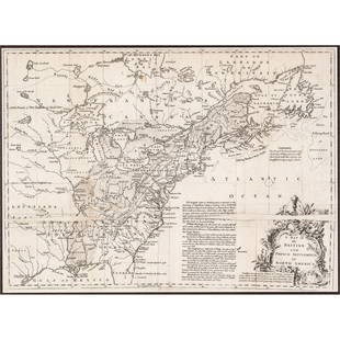
A Map of the British and French Settlements in North America (London, 1755)
Similar Sale History
View More Items in Maps & Atlases
Related Maps & Atlases
More Items in Maps & Atlases
View MoreRecommended Transportation & Travel Collectibles
View More


Item Details
Description
A Map of the British and French Settlements in North America (London, 1755) "A map of the British and French Settlements in North America" by Thomas Bowen, engraved two-part folding map with hand coloring, published in Gentleman's Magazine of Arts & Sciences, London, 1755. Showing the North American Colonies during the French and Indian War. Sight: 16 1/2 x 19 in. (41.9 x 48.3 cm.), Frame: 25 x 27 3/4 in. (63.5 x 70.5 cm.)
Condition
Condition reports are available upon request. The absence of a condition report does not imply an object is free of imperfections. Bidders are encouraged to inspect items in person or through a knowledgeable representative. If you have questions about condition, please contact Bray & Co. before placing your bid.
Buyer's Premium
- 28%
A Map of the British and French Settlements in North America (London, 1755)
Estimate $300 - $500
25 bidders are watching this item.
Shipping & Pickup Options
Item located in Portsmouth, NH, usSee Policy for Shipping
Local Pickup Available
Payment
Accepts seamless payments through LiveAuctioneers

TOP


![[MAP] BRITISH / FRENCH SETTLEMENTS NORTH AMERICA: Lodge, John. A MAP OF THE BRITISH AND FRENCH SETTLEMENTS IN NORTH AMERICA. London: circa 1750s. Handcoloured. Floral cartouche. The present example includes text detail on the English settlement claim](https://p1.liveauctioneers.com/8124/310027/165853621_1_x.jpg?height=310&quality=70&version=1700184289)


![MAPS - Maine. U.S. Gov.: Maine. U.S. Gov., [Lot of 2] Map of the Northern Part of the State of Maine and of the Adjacent British Provinces... [and] Extract from a Map of the British and French Dominions in North America, 1838](https://p1.liveauctioneers.com/6576/142214/71976779_1_x.jpg?height=310&quality=70&version=1557929467)


![The top sheet of the famous Ratzer Map - with additions relating to an 1810 real estate dispute: RATZER, BERNARD. Plan of the City of New York, in North America surveyed in the Years 1766 & 1767. [London: Jefferys & Faden, 12 January 1776.] Engraved map with hand coloring and manuscript a](https://p1.liveauctioneers.com/292/326828/175962862_1_x.jpg?height=310&quality=70&version=1713473479)
![A highly detailed map of New England after the Jansson-Visscher series: [MAP-NORTH AMERICA] [MONTANUS, ARNOLDUS]. Novi Belgii Quod nune Novi Jorck vocatur, Novae Angliae & Partis](https://p1.liveauctioneers.com/292/326828/175962858_1_x.jpg?height=310&quality=70&version=1713473479)


![A desirable early issue of Hondius map of Virginia and Florida: [MAP-NORTH AMERICA] MERCATOR, GERARD and HONDIUS, JOCODUS. Virginiae item et Floridae Americae Provinciarum, nova descriptio. [Amsterdam: Jodocus Hondius, 1607 or later]. Hand-colored engraved map. Wi](https://p1.liveauctioneers.com/292/326828/175962855_1_x.jpg?height=310&quality=70&version=1713473479)
![Homann's expansive map of North America: [MAP-NORTH AMERICA] HOMANN, JOHANN BAPTISTA.Regni Mexicani seu Novae Hispaniae Ludov](https://p1.liveauctioneers.com/292/326828/175962859_1_x.jpg?height=310&quality=70&version=1713473479)
![Jansson's important early map of New England: [MAP-NORTH AMERICA] JANSSON, JAN. Nova Belgica et Anglia Nova. Amsterdam: circa 1646. Latin text on verso. Neat lines 15 1/4 x 19 3/4 inches (38.7 x 50.5 cm). Marginal tears r](https://p1.liveauctioneers.com/292/326828/175962856_1_x.jpg?height=310&quality=70&version=1713473479)
![A marked improvement on the Hondius map of 1606 (Burden): [MAP-NORTH AMERICA] [JANSSON, JAN]. Virginiae partis australis et Floridae partis orientalis, interjacentiumq, regionum Nova Descriptio. Amsterdam: Blaeu, circa 1640. Second state (left cherub with ta](https://p1.liveauctioneers.com/292/326828/175962857_1_x.jpg?height=310&quality=70&version=1713473479)
![After De L'Ise's map of North America: [MAP-NORTH AMERICA] DE L'ISLE, GUILLAUME, after. L'Amerique Septentrionale Dressee sur les Observations de Mrs de l'Academie Royale des Sciences. Amsterdam: R.& J. Ottens, circa 1730 or later. Han](https://p1.liveauctioneers.com/292/326828/175962860_1_x.jpg?height=310&quality=70&version=1713473479)


