1777 Revolutionary War Map AMERICA SEPTENTRIKONAL
Similar Sale History
View More Items in Maps & Atlases
Related Maps & Atlases
More Items in Maps & Atlases
View MoreRecommended Transportation & Travel Collectibles
View More


Item Details
Description
Historic Maps
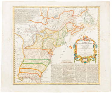
1777 AMERICA SEPTENTRIKONALIS... Homann Heirs
1777-Dated American Revolutionary War Period, Hand-Colored Engraved Map titled, "AMERICA SEPTENTRIKONALIS...," by Homann Heirs, Nuremberg, Choice Very Fine.
This Hand-Colored Engraved Map is fully titled: "AMERICA SEPTENTRIKONALIS A DOMINO D'ANVILLE IN GALLIIS EDITA NUNE IN ANGLIA COLONIIS IN INTERIOREM VIRGINIAM DEDUCTIS NEC NON FLUVII OHIO...". The text at upper left and decorative Cartouche bottom right in German, measuring 18" x 20" with bold outline coloring. This is the Revolutionary War issue of Homann's map that was originally published during the French and Indian War in 1756 after Jeffery's map from the previous year. This edition includes several alterations and updates plus the line "et ad bellum praesentis temporis accomodata" added to the imprint. It shows the area from James Bay and Newfoundland in the north to northern Florida and the Gulf coast in the south. It displays the British and French possessions during the first full year of the American Revolutionary War. The western extent of the Map is just west of the Mississippi River, this area is called "Mississippi or Louisiana." The boundaries of Virginia, and North Carolina extend westward off the Map. The boundary of New York still appears to cross Lakes Ontario, Huron and Erie to include the lower peninsula of Michigan, but the western extent is not clearly delineated. There is an early Georgia, but its boundary ends at the Mississippi. This Map is embellished with a large title cartouche. The extensive German text at upper left and lower right describes the British claims and French encroachments with historical context. As the American Revolutionary War was going on at this time, these boundaries would soon not hold true. A deep impression with the original outer Copper Plate embossed lines seen impressed within the heavy period paper. Dated 1777 and a nice example for display. See: McCorkle #756.1; Sellers & Van Ee #68.
Buyer's Premium
- 30%
1777 Revolutionary War Map AMERICA SEPTENTRIKONAL
Estimate $1,500 - $2,000
5 bidders are watching this item.
Shipping & Pickup Options
Item located in Rancho Santa Fe, CA, usOffers In-House Shipping
Payment

TOP


![[PICTORIAL MAPS – TRAVEL]. Three Pictorial Maps. 1940s/50s....: [PICTORIAL MAPS – TRAVEL]. Three Pictorial Maps. 1940s/50s. Three brochure sized foldout maps designed for travel including: Highroads to Happiness. Mexico City: Pemex Travel Club, ca. 1940s. &#](https://p1.liveauctioneers.com/928/325952/175495561_1_x.jpg?height=310&quality=70&version=1712935174)


![[Maps] Martin Zeiler, Itinerarium Italiae, 1640: [Maps] Martin Zeiler, Itinerarium Italiae, 1640, Martini Zeilleri. Itinerarium Italiae Nov-Antiquae: oder, Raiss-Beschreibung durch Italien, Matthaus Merian, Frankfurt, 40 plates, most double-page, in](https://p1.liveauctioneers.com/188/326797/176317459_1_x.jpg?height=310&quality=70&version=1713847031)


![[Maps] Gio. Ant. Magnini, Italia, 1620: [Maps] Gio. Ant. Magnini, Italia, 1620, Giovanni Antonio Magnini. Italia, data in luce da Fabio suo figliuolo al Serenissimo Ferdinado Gonzaga Duca di Matoua edi Monserrato etc. Bologna, for Sebastian](https://p1.liveauctioneers.com/188/326797/176317457_1_x.jpg?height=310&quality=70&version=1713847031)


