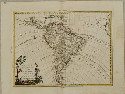
1818 Map I Stati Uniti Nell America Settentrionale
Similar Sale History
View More Items in Maps & Atlases
Related Maps & Atlases
More Items in Maps & Atlases
View MoreRecommended Transportation & Travel Collectibles
View More


Item Details
Description
Historic Maps
1818 Rare Map Titled "I Stati Uniti Nell' America Settentrionale" by A.B. Borghi, Florence, Italy Choice Crisp Near Mint
1818-Dated, Four-Sheet Copper-Engraved, Hand-Colored Outlines, Map of the United States, titled, "I Stati Uniti Nell' America Settentrionale" by A.B. Borghi, published in Florence, Italy, Choice Crisp Near Mint.
Superbly designed extremely rare four-sheet Map of America by A.B. Borghi, published in Florence, Italy. The Map shows east and west Florida, an oversized Mississippi Territory including Alabama, (mis-located Indiana below Lake Michigan), but with Chicao named and a host of interesting details in the east. However, it is in the West where this Map truly is best. The large Inset Map of Nuova Albion and Nuovo Georgia [Oregon Territory] is one of the best large format treatments of the region to date. Texas is named, with wonderful detail along the Arkansas River. Both Lake Timpanagos and Salso lake are named, with an explanation that part of Salsa lake is unknown. The details in the Missouri Valley and throughout the Rocky Mountains and Upper Plains is extraordinary, naming Indian Tribes, lakes, rivers, mountains, settlements etc. This is an exceptionally high quality crisp wide margin, unfolded, example of this rare 4-Sheet Map of the United States with hand-colored in outline. Each Map's Copper Plate outer outline, shows a strong impression into the paper, measures about 10" x 13" plus wide margins, sheets are 14.25" x 19". Very rare complete 4-sheet example of this Italian map of the United States, with wide full original untrimmed margins. Shown are east and west Florida; an oversized Mississippi Territory; a mis-located Indiana; and much detail in the Louisiana Territory (Luigiana), which extends to the headwaters of the Columbia River. Most notable, however, is the presence of the sheet of the southwest, featuring a large inset, "Supplemento per il fiume Columbia e Suoi Contorni," with Nuova Albion and Nuovo Georgia [Oregon Territory], including parts of Vancouver Island as well as the Pacific Northwest up from "Baja Bellingham." On the main part of that sheet, Texas is named, and there is a great deal of detail along the Arkansas River. Old numbers in upper corners of margins, some recent pencil notations in margins. References: Phillips (Maps) p. 439.
Buyer's Premium
- 30%
1818 Map I Stati Uniti Nell America Settentrionale
Estimate $1,200 - $1,600
2 bidders are watching this item.
Shipping & Pickup Options
Item located in Rancho Santa Fe, CA, usOffers In-House Shipping
Payment

Related Searches
TOP


![[PICTORIAL MAPS – TRAVEL]. Three Pictorial Maps. 1940s/50s....: [PICTORIAL MAPS – TRAVEL]. Three Pictorial Maps. 1940s/50s. Three brochure sized foldout maps designed for travel including: Highroads to Happiness. Mexico City: Pemex Travel Club, ca. 1940s. &#](https://p1.liveauctioneers.com/928/325952/175495561_1_x.jpg?height=310&quality=70&version=1712935174)
![[MAP]. TODESCHI, Pietro. [Nova et Acurata Totius Americae Tabula auct. G.I. Blaeu] America quarta: [MAP]. TODESCHI, Pietro. [Nova et Acurata Totius Americae Tabula auct. G.I. Blaeu] America quarta pars orbis quam plerunq, nuvum orbem appellitant primo detecta est anno 1492 a Christophoro Columbo...](https://p1.liveauctioneers.com/197/329395/177650542_1_x.jpg?height=310&quality=70&version=1715364962)


![[Maps] Gio. Ant. Magnini, Italia, 1620: [Maps] Gio. Ant. Magnini, Italia, 1620, Giovanni Antonio Magnini. Italia, data in luce da Fabio suo figliuolo al Serenissimo Ferdinado Gonzaga Duca di Matoua edi Monserrato etc. Bologna, for Sebastian](https://p1.liveauctioneers.com/188/326797/176317457_1_x.jpg?height=310&quality=70&version=1713847031)
![[Maps] Martin Zeiler, Itinerarium Italiae, 1640: [Maps] Martin Zeiler, Itinerarium Italiae, 1640, Martini Zeilleri. Itinerarium Italiae Nov-Antiquae: oder, Raiss-Beschreibung durch Italien, Matthaus Merian, Frankfurt, 40 plates, most double-page, in](https://p1.liveauctioneers.com/188/326797/176317459_1_x.jpg?height=310&quality=70&version=1713847031)


