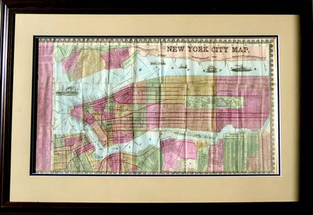
1836 Map of 25 Miles Round The City Of New-York.
Similar Sale History
View More Items in Maps & AtlasesRelated Maps & Atlases
More Items in Maps & Atlases
View MoreRecommended Transportation & Travel Collectibles
View More


Item Details
Description
Historic Maps
1836 "Map of the Country Twenty Five Miles Round The City Of New-York." Published by D.S. Stone
November 11, 1836-Dated, Hand-Colored Map titled, "Map of the Country Twenty Five Miles Round The City Of New-York." published by D.S. Stone, Framed, Very Fine.
This appealing original Hand-Colored Map measures about 11.75" x 13.25" (by sight), matted and framed to 16.25" x 17.5" not viewed out of the apparently original frame. Entered by Thomas Illman, published by D.S. Stone. Shows Manhattan, the boroughs of New York and surrounding terrain. Some light even tone and a 1.5" sealed split near the bottom left. This Map extends covering from Rockland County to Monmouth in New Jersey and from Morris County east as far as Hempstead. Considerable detail to roads, rivers, swamps, bays, rivers, islands and many more features. A scarce, very interesting map with colors in green, pink, yellow and tan.
Buyer's Premium
- 30%
1836 Map of 25 Miles Round The City Of New-York.
Estimate $600 - $800
1 bidder is watching this item.
Shipping & Pickup Options
Item located in Rancho Santa Fe, CA, usOffers In-House Shipping
Payment

Related Searches
TOP


![COLTON, George Woolworth (1827-1901). Map of the: COLTON, George Woolworth (1827-1901). Map of the Country Thirty Three Miles Around the City of New York. New York: J. H. Colton, 1846 [i.e., 1865]. Hand-colored lithographed map, visible area 23 3/4 b](https://p1.liveauctioneers.com/197/151909/76680338_1_x.jpg?height=310&quality=70&version=1570472488)


![[NEW YORK CITY – PICTORIAL MAPS]. Group of 3 pictorial maps...: [NEW YORK CITY – PICTORIAL MAPS]. Group of 3 pictorial maps. Including: ANNAND, George (1890—1980). Sinclair Pictorial Map of New York/New York World’s Fair. 26 ¾ x 27 5/8”](https://p1.liveauctioneers.com/928/325952/175495562_1_x.jpg?height=310&quality=70&version=1712935174)


![[Maps] Gio. Ant. Magnini, Italia, 1620: [Maps] Gio. Ant. Magnini, Italia, 1620, Giovanni Antonio Magnini. Italia, data in luce da Fabio suo figliuolo al Serenissimo Ferdinado Gonzaga Duca di Matoua edi Monserrato etc. Bologna, for Sebastian](https://p1.liveauctioneers.com/188/326797/176317457_1_x.jpg?height=310&quality=70&version=1713847031)
![[Maps] Martin Zeiler, Itinerarium Italiae, 1640: [Maps] Martin Zeiler, Itinerarium Italiae, 1640, Martini Zeilleri. Itinerarium Italiae Nov-Antiquae: oder, Raiss-Beschreibung durch Italien, Matthaus Merian, Frankfurt, 40 plates, most double-page, in](https://p1.liveauctioneers.com/188/326797/176317459_1_x.jpg?height=310&quality=70&version=1713847031)


![[MAP]. TODESCHI, Pietro. [Nova et Acurata Totius Americae Tabula auct. G.I. Blaeu] America quarta: [MAP]. TODESCHI, Pietro. [Nova et Acurata Totius Americae Tabula auct. G.I. Blaeu] America quarta pars orbis quam plerunq, nuvum orbem appellitant primo detecta est anno 1492 a Christophoro Columbo...](https://p1.liveauctioneers.com/197/329395/177650542_1_x.jpg?height=310&quality=70&version=1715364962)


