


1853 Williamson Map of California's Tejon Pass Area --
Similar Sale History
View More Items in Maps & Atlases


![COLTON, George Woolworth (1827-1901). Map of the: COLTON, George Woolworth (1827-1901). Map of the Country Thirty Three Miles Around the City of New York. New York: J. H. Colton, 1846 [i.e., 1865]. Hand-colored lithographed map, visible area 23 3/4 b](https://p1.liveauctioneers.com/197/151909/76680338_1_x.jpg?height=310&quality=70&version=1570472488)


![Map of U.S., 1846: *** START PRICE IS THE RESERVE *** [America] HAVEN & EMMERSON. Map of the United States and Mexico Including Oregon, Texas and the Californias. Engraved map with original hand color. New York, 1846. 1](https://p1.liveauctioneers.com/1968/163248/82424576_1_x.jpg?height=310&quality=70&version=1583340284)


![Geologic Atlas of California; 1969 [153283]: Geologic Atlas of California published by the California Division of Mines and Geology in 1969. Includes various geological maps of various California areas including Redding, Los Angeles, Santa Cruz,](https://p1.liveauctioneers.com/2699/254728/132473485_1_x.jpg?height=310&quality=70&version=1657577698)

Related Maps & Atlases


![1593 de Jode Maps of Eastern Germany (Saxony Area) and Western Germany -- Mansfeldiae Comitatus ...: Title: 1593 de Jode Maps of Eastern Germany (Saxony Area) and Western Germany -- Mansfeldiae Comitatus ... [on sheet with] Clivensis et Iuliacensis Ducatum Cartographer: G De Jode Year / Place: 1593,](https://p1.liveauctioneers.com/5584/330117/177981830_1_x.jpg?height=310&quality=70&version=1716324705)


![[MAP]. ORTELIUS, Abraham. Africae Tabula Nova. 1592.: [MAP]. ORTELIUS, Abraham (1527-1598). Africae Tabula Nova. Antwerp, 1592. Engraved map with hand-coloring. Matted, framed, and double glazed, visible area 406 x 533 mm (unexamined out of frame). Strap](https://p1.liveauctioneers.com/197/329395/177650533_1_x.jpg?height=310&quality=70&version=1715364962)


More Items in Maps & Atlases
View More


![[MAP]. TODESCHI, Pietro. [Nova et Acurata Totius Americae Tabula auct. G.I. Blaeu] America quarta: [MAP]. TODESCHI, Pietro. [Nova et Acurata Totius Americae Tabula auct. G.I. Blaeu] America quarta pars orbis quam plerunq, nuvum orbem appellitant primo detecta est anno 1492 a Christophoro Columbo...](https://p1.liveauctioneers.com/197/329395/177650542_1_x.jpg?height=310&quality=70&version=1715364962)


![[MAPS]. HOMANN, Johann Baptist, HOMANN HEIRS, and Georg Matthäus SEUTTER. [Composite Atlas].: [MAPS]. HOMANN, Johann Baptist (1663-1724), HOMANN HEIRS, and Georg Matthäus SEUTTER (1678-1757). [Composite Atlas]. [Nuremberg, Augsburg, and others: Homann Heirs and others, maps dated between](https://p1.liveauctioneers.com/197/329395/177650530_1_x.jpg?height=310&quality=70&version=1715364962)

Recommended Transportation & Travel Collectibles
View More


Item Details
Description
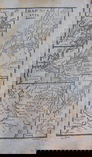
This is a highly detailed topographical map of the region centers on California's Tejon Pass, including the Tulare Valley, and the Kern and Buenavista Lakes. Walker's Pass, Hum-pah-map Pass, Tah-ee-chay-pay Pass, Tejon Pass, Arroyo de las Uvas, Arroyo de San Arminio, and Fremont's route through the region are located. A wagon road through Tejon Pass and a new pass are also identified. From Reports of Explorations and Surveys, to Ascertain the Most Practicable and Economical Route for Railroad from the Mississippi River to the Pacific Ocean… 1853-56 Volume XI
Reserve: $160.00
Shipping:
Your purchase is protected:
Photos, descriptions, and estimates were prepared with the utmost care by a fully certified expert and appraiser. All items in this sale are guaranteed authentic.
In the rare event that the item did not conform to the lot description in the sale, Jasper52 specialists are here to help. Buyers may return the item for a full refund provided you notify Jasper52 within 5 days of receiving the item.
Condition
Very Good. Slight toning, more in issued folds. A few smaller foxing spots. Uncolored.
Buyer's Premium
- 15%
1853 Williamson Map of California's Tejon Pass Area --
Estimate $200 - $250
2 bidders are watching this item.
Shipping & Pickup Options
Item located in Ohio, US$16 shipping in the US
Payment
Accepts seamless payments through LiveAuctioneers
See More Items From This Jasper52 Seller

Related Searches
TOP