Sold20211853 Williamson Map of California's Tejon Pass Area --Title: 1853 Williamson Map of California's Tejon Pass Area -- Map of the Passes in the Sierra Nevada from Walker's Pass to the Coast Range under the direction of the Hon. Jefferson Davis, Secretary ofSee Sold Price
Sold2023Williamson, Lieut. R. S. 1856 Map. California - Tejon Pass & Canada de las Uvas"Geological Map of the Tejon Pass & Canada de las Uvas and the Vicinity. Including the Pass of San Francisco & Williamsons Pass"Lithograph Map Published 1853-61, Washington for "Reports of explorationSee Sold Price
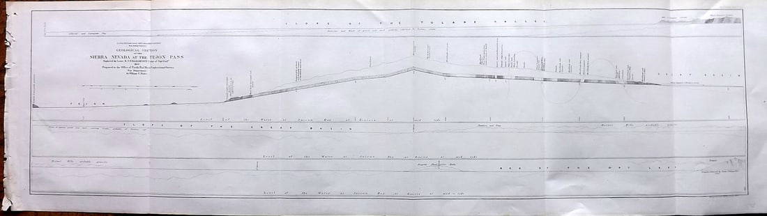
Sold2023Williamson, Lieut. R. S. 1856 LG Chart. California - Sierra Nevada & Tejon Pass"Goelogical Section of the Sierra Nevada at the Tejon Pass" by R. S. Williamson. Lithograph Map Published 1853-61, Washington for "Reports of explorations and surveys, to ascertain the most practicablSee Sold Price
Sold20211853 Geological Map of Passes by St. Gabriel Mountains,Title: 1853 Geological Map of Passes by St. Gabriel Mountains, CA -- Geological Map of the Tejon Pass & Canada de las Unas Including the Pass of San Franciscoquito & Williamson's Pass Cartographer: WSee Sold Price
Sold2023Williamson, Lieut. R. S. 1856 LG Chart. California - Bernadino Pass, San Bernardino, Colorado Desert"Geological Sections of the Bernadino Pass" Lithograph Map Published 1853-61, Washington for "Reports of explorations and surveys, to ascertain the most practicable and economical route for a railroadSee Sold Price
Sold20221853 Immense Williamson Map of California -- General Map of Explorations and Surveys In CaliforniaTitle: 1853 Immense Williamson Map of California -- General Map of Explorations and Surveys In California under the direction of the Hon. Jefferson Davis, Secretary of War… Cartographer: R WilliSee Sold Price
Sold2023Williamson, Lieut. R. S. 1856 Map. California, New Mexico, Texas, Mexico"United States & Mexican Boundary Survery" Lithograph Map Published 1853-61, Washington for "Reports of explorations and surveys, to ascertain the most practicable and economical route for a railroadSee Sold Price
Sold2023Williamson, Lieut. R. S. 1856 LG Chart. California - Colorado Desert"Sections of the Colorado Desert" Explored by Lieut R. S. Williamson. Lithograph Map Published 1853-61, Washington for "Reports of explorations and surveys, to ascertain the most practicable and econoSee Sold Price
Sold2023Williamson, Lieut. R. S. 1856 Map. Vicinity of San Francisco California"Geological Map of the Vicinity of San Francisco" by William P. Blake. Lithograph Map Published 1853-61, Washington for "Reports of explorations and surveys, to ascertain the most practicable and econSee Sold Price
Sold2023Williamson, Lieut. R. S. 1856 HC Map. San Diego & Colorado River California"Geological Map of the Country Between San Diego and the Colorado River California" By W. P. Blake. Hand Colored Lithograph Map Published 1853-61, Washington for "Reports of explorations and surveys,See Sold Price
Sold2023Williamson, Lieut. R. S. 1856 LG Chart. California - Bernardino Sierra, San Pedro"Geological Section of the Bernardino Sierra from the Great Basin to the Pacific ocean at San Pedro" by William P. Blake. Lithograph Map Published 1853-61, Washington for "Reports of explorations andSee Sold Price
Sold2023Williamson, Lieut. R. S. 1856 LG Chart. California - Colorado River to the Pacific Ocean"Geological Section from the Colorado River to the Pacific Ocean" by William P. Blake. Lithograph Map Published 1853-61, Washington for "Reports of explorations and surveys, to ascertain the most pracSee Sold Price
Sold2023Williamson, Lieut. R. S. 1856 LG Chart. California - Coast Mountains & Sierra Nevada"Geological Section of the Coast Mountains and Sierra Nevada" by W. P. Blake. Lithograph Map Published 1853-61, Washington for "Reports of explorations and surveys, to ascertain the most practicable aSee Sold Price
Sold2018U.S. Coast Survey 1853 Map of Aransas Pass, Texas"Reconnoissance of Aransas Pass Texas" Electrotype Map Published 1843-65, Washington for "Report of the Superintendent of the U.S. Coast Survey..." Published under the supervision and direction of AleSee Sold Price
Sold2018U.S Coast Survey 1853 Map. Cortez Bank, California"Cortez Bank on the Western Coast of the United States" Electrotype Map Published 1843-65, Washington for "Report of the Superintendent of the U.S. Coast Survey..." Published under the supervision andSee Sold Price
Sold2022Geologic Atlas of California; 1969 [153283]Geologic Atlas of California published by the California Division of Mines and Geology in 1969. Includes various geological maps of various California areas including Redding, Los Angeles, Santa Cruz,See Sold Price
Sold2023Williamson, Lieut. R. S. 1856 LG HC Map. California - First Geological Map"Geological Map of a Part of the State of California" Explored in 1855 by Lieut R. S. Williamson. Prepared to accompany the Report of William P. Blake. THE FIRST GEOLOGY MAP OF CALIFORNIA. Hand ColoreSee Sold Price
Sold2021Beautiful map of S.F. Bay Region 1873Heading: (California - San Francisco Bay Area) Author: California, State Geological Survey Title: Map of the Region Adjacent to the Bay of San Francisco... Place Published: [n.p.] Publisher: DateSee Sold Price
Sold20231855 Williamson Map of San Francisco Bay to Oregon -- Map No. 1 From San Francisco Bay to theTitle: 1855 Williamson Map of San Francisco Bay to Oregon -- Map No. 1 From San Francisco Bay to the Northern Boundary of California from Explorations and Surveys Made Under the Direction of Hon. JeffSee Sold Price
Sold2024Map of California, Utah, Oregon,New Mexico 1853Map of California, Utah, Oregon,New Mexico, Washington and Nebraska Hand colored. Map No 10 United States Cartographer: Jules Sherman Smith Publisher Daniel Burgess Dated: 1853<See Sold Price
Sold2020California 1856 Lot of 7 Large Railroad Survey ChartsIncl Sierra Nevada, Tejon Pass, Tejon Ravine, Bernardino Sierra/San Pedro, Colorado Desert, Bernardino Pass, Colorado River, and Coast Mountains from San Francisco to the Great Basin. Lithographs PublSee Sold Price
Sold2018U.S Coast Survey 1853 Map. Timballier Bay, Louisiana"Preliminary Reconnaissance of Grand Pass Entrance to Timballier Bay Louisiana" Electrotype Map Published 1843-65, Washington for "Report of the Superintendent of the U.S. Coast Survey..." Published uSee Sold Price
Sold20181853 Imray Chart of the Black Sea Area -- Chart of theTitle/Content of Map: 1853 Imray Chart of the Black Sea Area -- Chart of the Black Sea and Seas of Marmora and Azov, Drawn Principally from the Surveys Made by Order of the English, French and RussianSee Sold Price
Sold2016Map of California, 1899By Rand, McNally & Co., from Indexed Atlas Of The World. Chicago: 1899. Map features vignettes of Los Angeles, San Bernadino, Orange & San Diego Counties and seperate vignette of San Francisco area. DSee Sold Price
Jun 08Early American History Auctions1853 Specialized Map, Railroads in the United States in Operation and Progress... Treasury Deptment$200(1 bid)
Jun 23Schilb Antiquarian Rare Books1848 Emory Military Reconnaissance 1ed California MAP Indians Texas New Mexico$2(2 bids)
Featured5 days LeftJasper521867 Beers Map of New York City Area -- Map of New York and Vicinity Accompanying "Atlas of New York$200
Jun 06Akiba GalleriesAntique Mast, Crowell, & Kirkpatrick Map Of Texas, California, & Nevada$25(1 bid)
May 31Freeman's | Hindman[CALIFORNIA - EARLY PHOTOGRAPHY]. Whole plate daguerreotype of San Francisco, California. Circa$15,000
2 days LeftCain Modern AuctionsDouble Sided U.S. Map by Rand McNally, Illustrated & Equal Area Projection$75
Jun 07Freeman's | Hindman[MAP]. ORTELIUS, Abraham. Americae Sive Novi Orbis, Nova Descriptio. 1573.$1,000(1 bid)
Jun 07Freeman's | Hindman[MAP]. ORTELIUS, Abraham. Peregrinationis Divi Pauli Typus Corographicus. 1592.$150(1 bid)
Jun 07Freeman's | HindmanCASSIN, John. Illustrations of the Birds of California, Texas, Oregon, British and Russian American.$500
Jun 01Black Hills Curio CompanyAntique Dated 1910 Happy Camp Photo California Redwood Forest Logging Lumber Jacks$150
6 days LeftForum AuctionsAmerica.- California gold mining.- Palmer (N.S.) Autograph Letter signed to his brother on mining£400
Jun 07Freeman's | Hindman[MAP]. ORTELIUS, Abraham. Presbiteri Iohannis, sive, Abissinorum Imperii Descriptio. 1592.$200
Jun 08Early American History Auctions1776 Map, PARTIE ORIENTALE DU CANADA, AVEC LA NOUVELLE ANGLETERRE, L'ACADIE... by P. Santini, Framed$950
Jun 22Check the Oil Promotions, LLCStandard Red Crown of California Gas Pump Paddle Sign DSP$25(1 bid)


![Geologic Atlas of California; 1969 [153283]: Geologic Atlas of California published by the California Division of Mines and Geology in 1969. Includes various geological maps of various California areas including Redding, Los Angeles, Santa Cruz,](https://p1.liveauctioneers.com/2699/254728/132473485_1_x.jpg?height=310&quality=70&version=1657577698)

![Beautiful map of S.F. Bay Region 1873: Heading: (California - San Francisco Bay Area) Author: California, State Geological Survey Title: Map of the Region Adjacent to the Bay of San Francisco... Place Published: [n.p.] Publisher: Date](https://p1.liveauctioneers.com/642/204898/103986346_1_x.jpg?height=310&quality=70&version=1621652446)


![[CALIFORNIA - EARLY PHOTOGRAPHY]. Whole plate daguerreotype of San Francisco, California. Circa (1 of 7)](https://p1.liveauctioneers.com/197/329785/177758569_1_x.jpg?height=282&quality=70&version=1715625218)

![[MAP]. ORTELIUS, Abraham. Africae Tabula Nova. 1592. (1 of 2)](https://p1.liveauctioneers.com/197/329395/177650533_1_x.jpg?height=282&quality=70&version=1715364962)


![[MAP]. ORTELIUS, Abraham. Americae Sive Novi Orbis, Nova Descriptio. 1573. (1 of 2)](https://p1.liveauctioneers.com/197/329395/177650534_1_x.jpg?height=282&quality=70&version=1715364962)
![[MAP]. ORTELIUS, Abraham. Aevi Veteris, Typus Geographicus. 1601. (1 of 3)](https://p1.liveauctioneers.com/197/329395/177650532_1_x.jpg?height=282&quality=70&version=1715364962)
![[MAP]. ORTELIUS, Abraham. Romani Imperii Imago. 1592. (1 of 2)](https://p1.liveauctioneers.com/197/329395/177650537_1_x.jpg?height=282&quality=70&version=1715364962)
![[MAP]. ORTELIUS, Abraham. Peregrinationis Divi Pauli Typus Corographicus. 1592. (1 of 2)](https://p1.liveauctioneers.com/197/329395/177650535_1_x.jpg?height=282&quality=70&version=1715364962)


![[MAP]. ORTELIUS, Abraham. Presbiteri Iohannis, sive, Abissinorum Imperii Descriptio. 1592. (1 of 2)](https://p1.liveauctioneers.com/197/329395/177650536_1_x.jpg?height=282&quality=70&version=1715364962)


