Sold2023USC&GS Map, Sand Key to Rebecca Shoal, U.S Gulf CoastA color map depicting the land and sea area of the Sand Key to the Rebecca Shoal. Publishing stamp by "The U.S Department of Commerce Coast and Geodetic Survey" located on bottom. Issued: 20thSee Sold Price
Sold2023USC&GS Map, Sand Key to Rebecca Shoal, U.S Gulf CoastA map depicting the islands along the gulf coast along with the gulf. Publishing stamp by "The U.S Coast and Geodetic Survey" located on bottom. Issued: 1933 Dimensions: 44"L x 34.5"W Manufacturer: U.See Sold Price
Sold2023USC&GS Map, Sombrero Key to Sand Key, Florida Gulf CoastA colored map depicting the area of the Gulf Coast from the Sombrero Key to the Sand Key. Publishing stamp by "The U.S Coast and Geodetic Survey" located on bottom. Issued: 1940 Dimensions: 43"L x 35"See Sold Price
Sold2023USC&GS Map, Sombrero Key to Sand Key, Florida Gulf CoastA color map depicting the land and sea area of the Sombrero Key to the Sand Key. Publishing stamp by "The U.S Coast and Geodetic Survey" located on bottom. Issued: 1954 Dimensions: 43.5"L x 36See Sold Price
Sold2023DOC Map, Alligator Reef to Sombrero Key, U.S Gulf CoastA color map depicting the area of Alligator Alley to the Sombrero Key. Publishing stamp by "The U.S Department of Commerce" located on bottom. Issued: 1940 Dimensions: 43.5"L x 34"W ManufacturSee Sold Price
Sold2023USC&GS Map, Alligator Reef to Sombrero Key, U.S Gulf CoastA color map depicting the area of Alligator Alley to the Sombrero Key. Publishing stamp by "The U.S Coast and Geodetic Survey" located on bottom. Issued: 1940 Dimensions: 43.5"L x 34"W ManufacSee Sold Price
Sold2023USC&GS Map, Fowey Rocks to American Shoal, Florida KeysA color map showing the land and sea area of Fowey Rocks to American Shoal. Publishing stamp by "The U.S Coast and Geodetic Survey" located on bottom. Issued: 1940 Dimensions: 38.5"L x 34"W MaSee Sold Price
Sold2023USC&GS Map, Fowey Rocks to American Shoal, Florida KeysA color map showing the land and sea area of Fowey Rocks to American Shoal. Publishing stamp by "The U.S Coast and Geodetic Survey" located on bottom. Issued: 1940 Dimensions: 38.5"L x 34"W MaSee Sold Price
Sold2023USC&GS Map, Alligator Reef to Sombrero Key, FL Gulf CoastTitle "USC&GS Map, Alligator Reef to Sombrero Key, Florida Gulf Coast". A color map depicting the land and sea area of Alligator Reef to the Sombrero Key. Publishing stamp by "The U.S Coast and GeodetSee Sold Price
Sold2017SDUK: Antique Map of US Gulf Coast, 1846Title/Content of Map: 'NORTH AMERICA, SHEET XIII., Parts of Louisiana, Arkansas, Mississippi, Alabama & Florida' Native American settlements are named on the map west of the Mississippi, some marked wSee Sold Price
Sold2023USC&GS Map, Chatham River to Clam Pass, U.S Gulf CoastA map of the Gulf Coast of Florida from Chatham River to Clam Pass shown in feet. Publishing stamp by "The U.S Coast and Geodetic Survey" located on bottom. Issued: 1931 Dimensions: 43.5"L x 3See Sold Price
Sold2023USC&GS Map, Chatham River to Clam Pass, U.S Gulf CoastA map of the Gulf Coast of Florida from Chatham River to Clam Pass shown in feet. Publishing stamp by "The U.S Coast and Geodetic Survey" located on bottom. Issued: 20th Century Dimensions: 43See Sold Price
Sold2019US GULF COAST Louisiana Mississippi Alabama FloridaTITLE/CONTENT OF MAP: 'NORTH AMERICA, SHEET XIII., Parts of Louisiana, Arkansas, Mississippi, Alabama, Florida' DATE PRINTED: 1874 IMAGE SIZE: Approx 32.5 x 42.0cm, 12.75 x 16.5 inches (Large) TYPE: ASee Sold Price
Sold2024USC&GS Map, Elliot Key to Florida Bay, Intercoastal WaterwayTitle "USC&GS Map, Elliot Key to Florida Bay, Florida Intercoastal Waterway" Depicts a color map of the Intracoastal Waterway from Key Elliot to the Florida Bay. Publishing stamp by "The U.S Coast andSee Sold Price
Sold2018U.S Coast Survey 1853 Map. Ship Island Shoal, Louisiana"Preliminary Chart of Ship Island Shoal Louisiana" Electrotype Map Published 1843-65, Washington for "Report of the Superintendent of the U.S. Coast Survey..." Published under the supervision and direSee Sold Price
Sold2024USC&GS Map, Barnes Sound to Key West, Intercoastal WaterwayTitle "USC&GS Map, Barnes Sound to Key West, Florida Intercoastal Waterway". Depicts a color map of the Intracoastal Waterway from Barnes Sound to Key West. Publishing stamp by "The U.S Coast and GeodSee Sold Price
Sold2020(Sketch F, No.5) Preliminary Chart of Key West HarborTitle/Content of Map: (Sketch F, No.5) Preliminary Chart of Key West Harbor and Approaches... 1851 Publication Date: 1851 Cartographer: KNORR, E. K./ISSAC HULL ADAMS Publisher: U.S. COAST SURVEY DescrSee Sold Price
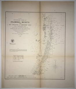
Sold2020(F No.4) Preliminary Chart of Florida Reefs from KeyTitle/Content of Map: (F No.4) Preliminary Chart of Florida Reefs from Key Biscayne to Carysfort Reef... Publication Date: 1855 Cartographer: Totten, Jas./I. Hull Adams Publisher: U.S. Coast Survey DeSee Sold Price
Sold2018ENGLAND EAST COAST Sea 'chart for the Newcastle Trade'.TITLE/CONTENT OF MAP: 'A chart for the Newcastle Trade describing the sea coasts of England from the South Foreland to Newcastle with the soundings, sands, shoals, harbours, buoys, beacons and seamarkSee Sold Price
Sold2018NORTH SEA coast chart. East Anglia Holland Flanders.TITLE/CONTENT OF MAP: 'A correct chart of the sea coasts of England, Flanders and Holland. Shewing the sands, shoals, rocks and dangers, the bays, harbours, roads, buoys, beacons & seamarks on the saiSee Sold Price
Sold2017Hand-Colored Lithograph Map of the Gulf of MexicoImpressive Hand-Colored Lithograph Map of the Gulf of Mexico, titled "U.S. Coast Survey, A.D. Bache Superintendent, Sketch H, Showing the Progress of the Survey in Section No. 8, 1846-1854", the map iSee Sold Price
Sold2019U S Coast Survey 1896 LG Map. New Orleans Texas Florida"Sketch of General Progress June 30. 1896" Showing Southern, Eastern and Mid West States, incl Florida, Texas, Gulf of Mexico, Georgia etc. Large Lithograph Map Published 1896, Washington for "U.S. CoSee Sold Price
Sold2023MAP: United States - East Coast/ Approaches to New York/ Nantucket ShoalsDescription: United States - East Coast/ Approaches to New York/ Nantucket Shoals to Five Fathom Bank. For LORAN - C coverage - see reverse side. Published at Washington D.C. US Department of CommerceSee Sold Price
Sold20231853 U.S. Coast Survey Map of New Orleans1853 U.S. Coast Survey Map of New Orleans, Lake Pontchartrain and the Mississippi Delta hand-colored lithograph, inscribed "U.S. Coast Survey, A. D. Bache Superintendent, Sketch H, Showing the progresSee Sold Price
5 days LeftJasper52Title/Content of Map: Haiti: Fondeadero de Chouchou (N. coast of Haiti) and Bahia de la Granja by$55
5 days LeftJasper52Title/Content of Map: Jamaica: Port Mosquito Coast, by Ferrer, 1818 Date Printed: 1818$55
Jun 08Simpson Galleries, LLC.JULIUS BIEN (1826-1909) AN AMERICAN CIVIL WAR RECONNAISSANCE MAP, "Map of Texas and Part of New$100
Echoes of Glory International Military Auction HouseNotorious US Navy Captain Robert C. Klosterman's HELLRAZOR Flight Suit(KDW)$120(16 bids)
Echoes of Glory International Military Auction HouseNotorious US Navy Captain Robert C. Klosterman's VFA-106 Gladiator Flight Suit (KDW)$110(15 bids)
Echoes of Glory International Military Auction HouseNotorious US Navy Captain Robert C. Klosterman's HELLRAZOR Flight Suit (KDW)$110(13 bids)
5 days LeftJasper52Title/Content of Map: Puerto Rico: Port of Guánica by Ferrer Date Printed: 1818$55
Echoes of Glory International Military Auction HouseNotorious Captain Robert C. Klosterman's Aircraft Carrier USS Stennis Commissioning Plaque (KDW)$275(17 bids)
Echoes of Glory International Military Auction HouseUS Coast Guard WWII, Korea, Vietnam, Desert Storm, War on Terrorism Ribbon Rack (CPD)$18(15 bids)
5 days LeftHeritage Auctions70277: An Olmec Jade Spoon Pendant Gulf Coast, Mexico,$750
5 days LeftHeritage Auctions70273: An Olmec Jade Pendant Gulf Coast, Mexico, c. 12$600
2 days LeftLink Auction GalleriesDry, Camille, N. Pictorial St. Louis: The Great Metropolis of the Mississippi Valley. A$1,500
Jun 27Rail & Road AuctionsFive Steel Body Railroad Locks - Big Four, C&N?, Illinois Central Gulf, Gulf Mobile and Ohio$30
19 hrs LeftFreeman's | Hindman[CIVIL WAR]. Archive of items related to Elisha Hunt RHODES (1842-1917), 2nd Rhode Island Volunteer$750


![[CIVIL WAR]. Archive of items related to Elisha Hunt RHODES (1842-1917), 2nd Rhode Island Volunteer (1 of 6)](https://p1.liveauctioneers.com/197/329785/177758366_1_x.jpg?height=282&quality=70&version=1715625218)