Sold2023USC&GS Map, Sombrero Key to Sand Key, Florida Gulf CoastA colored map depicting the area of the Gulf Coast from the Sombrero Key to the Sand Key. Publishing stamp by "The U.S Coast and Geodetic Survey" located on bottom. Issued: 1940 Dimensions: 43"L x 35"See Sold Price
Sold2023USC&GS Map, Sombrero Key to Sand Key, Florida Gulf CoastA color map depicting the land and sea area of the Sombrero Key to the Sand Key. Publishing stamp by "The U.S Coast and Geodetic Survey" located on bottom. Issued: 1954 Dimensions: 43.5"L x 36See Sold Price
Sold2023USC&GS Map, Alligator Reef to Sombrero Key, FL Gulf CoastTitle "USC&GS Map, Alligator Reef to Sombrero Key, Florida Gulf Coast". A color map depicting the land and sea area of Alligator Reef to the Sombrero Key. Publishing stamp by "The U.S Coast and GeodetSee Sold Price
Sold2023USC&GS Map, Sand Key to Rebecca Shoal, U.S Gulf CoastA color map depicting the land and sea area of the Sand Key to the Rebecca Shoal. Publishing stamp by "The U.S Department of Commerce Coast and Geodetic Survey" located on bottom. Issued: 20thSee Sold Price
Sold2023USC&GS Map, Sand Key to Rebecca Shoal, U.S Gulf CoastA map depicting the islands along the gulf coast along with the gulf. Publishing stamp by "The U.S Coast and Geodetic Survey" located on bottom. Issued: 1933 Dimensions: 44"L x 34.5"W Manufacturer: U.See Sold Price
Sold2023DOC Map, Alligator Reef to Sombrero Key, U.S Gulf CoastA color map depicting the area of Alligator Alley to the Sombrero Key. Publishing stamp by "The U.S Department of Commerce" located on bottom. Issued: 1940 Dimensions: 43.5"L x 34"W ManufacturSee Sold Price
Sold2023USC&GS Map, Alligator Reef to Sombrero Key, U.S Gulf CoastA color map depicting the area of Alligator Alley to the Sombrero Key. Publishing stamp by "The U.S Coast and Geodetic Survey" located on bottom. Issued: 1940 Dimensions: 43.5"L x 34"W ManufacSee Sold Price
Sold2024USC&GS Map, Elliot Key to Florida Bay, Intercoastal WaterwayTitle "USC&GS Map, Elliot Key to Florida Bay, Florida Intercoastal Waterway" Depicts a color map of the Intracoastal Waterway from Key Elliot to the Florida Bay. Publishing stamp by "The U.S Coast andSee Sold Price
Sold2024USC&GS Map, Barnes Sound to Key West, Intercoastal WaterwayTitle "USC&GS Map, Barnes Sound to Key West, Florida Intercoastal Waterway". Depicts a color map of the Intracoastal Waterway from Barnes Sound to Key West. Publishing stamp by "The U.S Coast and GeodSee Sold Price
Sold2023USC&GS Map, Fowey Rocks to American Shoal, Florida KeysA color map showing the land and sea area of Fowey Rocks to American Shoal. Publishing stamp by "The U.S Coast and Geodetic Survey" located on bottom. Issued: 1940 Dimensions: 38.5"L x 34"W MaSee Sold Price
Sold2023USC&GS Map, Fowey Rocks to American Shoal, Florida KeysA color map showing the land and sea area of Fowey Rocks to American Shoal. Publishing stamp by "The U.S Coast and Geodetic Survey" located on bottom. Issued: 1940 Dimensions: 38.5"L x 34"W MaSee Sold Price
Sold2021Nice map of SE coast of U. S. (Colton)Clean map of the southeast coast of the United States, with good detail. Shows railroad lines, towns, rivers, lakes, swamps, islands and coastal features. Inset of the Florida Keys. Full, original hanSee Sold Price
Sold2021Railroad Lock Keys (11), various Florida RR LinesID Marks: LOP&GRR (Live Oak Perry & Gulf RR); JTCO (Jacksonville Terminal Co); FECRY (Florida East Coast RY); ANRR (Apalachicola & Northern RR); SAL (Seaboard Air Line); FECRY (Florida East Coast RY);See Sold Price
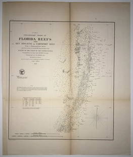
Sold2020(F No.4) Preliminary Chart of Florida Reefs from KeyTitle/Content of Map: (F No.4) Preliminary Chart of Florida Reefs from Key Biscayne to Carysfort Reef... Publication Date: 1855 Cartographer: Totten, Jas./I. Hull Adams Publisher: U.S. Coast Survey DeSee Sold Price
Sold2019U S Coast Survey 1896 LG Map. Gulf Coast. Florida, MI"Sketch Showing Progress of Surveys on the Gulf Coast Lake Pontchartrain Mobile and Pensacola Bays" Detailed map showing New Orleans to Santa Rosa Sound, with inset showing Tortugas Harbor. Large LithSee Sold Price
Sold2020Homann Heirs Map of the West Indies and Mexico 17Homann Heirs, "Mappa Geographica complectens I. Indiae Occidentalis Partem Mediam Circum Isthmum Panamensem," Nuremberg, 1740. Hand colored map of the Gulf Coast, Florida, and the Caribbean, with inseSee Sold Price
Sold2023USC&GS Map, Chatham River to Clam Pass, U.S Gulf CoastA map of the Gulf Coast of Florida from Chatham River to Clam Pass shown in feet. Publishing stamp by "The U.S Coast and Geodetic Survey" located on bottom. Issued: 1931 Dimensions: 43.5"L x 3See Sold Price
Sold2023USC&GS Map, Chatham River to Clam Pass, U.S Gulf CoastA map of the Gulf Coast of Florida from Chatham River to Clam Pass shown in feet. Publishing stamp by "The U.S Coast and Geodetic Survey" located on bottom. Issued: 20th Century Dimensions: 43See Sold Price
Sold2019US GULF COAST Louisiana Mississippi Alabama FloridaTITLE/CONTENT OF MAP: 'NORTH AMERICA, SHEET XIII., Parts of Louisiana, Arkansas, Mississippi, Alabama, Florida' DATE PRINTED: 1874 IMAGE SIZE: Approx 32.5 x 42.0cm, 12.75 x 16.5 inches (Large) TYPE: ASee Sold Price
Sold20181911-D G$2.5 Indian Head Quarter Eagle NGC AU Det.1911-D $2.5 Indian Head Gold Quarter Eagle NGC AU Details Reverse Scratched, Cleaned. Low Mintage, Key Date.See Sold Price
Sold20181911-D $2.5 Indian Gold Quarter Eagle NGC AU Det.1911-D $2.5 Indian Head Gold Quarter Eagle NGC AU Details Obverse Scratched, Cleaned. Low Mintage, Key Date.See Sold Price
Sold20181927 Peace Silver Dollar PCGS MS65 Green CAC1927 Peace Silver Dollar PCGS MS65 Green CAC. A semi-key date in the series with a low mintage, this better date Gem BU coin has the green CAC sticker of approval.See Sold Price
Sold2017SDUK: Antique Map of US Gulf Coast, 1846Title/Content of Map: 'NORTH AMERICA, SHEET XIII., Parts of Louisiana, Arkansas, Mississippi, Alabama & Florida' Native American settlements are named on the map west of the Mississippi, some marked wSee Sold Price
Sold2019U S Coast Survey 1896 LG Map. New Orleans Texas Florida"Sketch of General Progress June 30. 1896" Showing Southern, Eastern and Mid West States, incl Florida, Texas, Gulf of Mexico, Georgia etc. Large Lithograph Map Published 1896, Washington for "U.S. CoSee Sold Price
Jun 08Simpson Galleries, LLC.JULIUS BIEN (1826-1909) AN AMERICAN CIVIL WAR RECONNAISSANCE MAP, "Map of Texas and Part of New$100
2 days LeftJasper521693 Jaillot Map of the Adriatic Sea and Much of Italy -- Le Golfe de Venise, Avec ses Principaux$500
6 days LeftLink Auction GalleriesDry, Camille, N. Pictorial St. Louis: The Great Metropolis of the Mississippi Valley. A$1,500
7 days LeftGold Coast Auctioneers19th c. French Aiguilles Gilt Bronze Carriage Clock w/ Key$50(1 bid)
6 days LeftRipley AuctionsEnrique Guijo, Madrid, (1871-1945), framed Spanish Azulejo Majolica tile mural panel depicting$100
6 days LeftRipley AuctionsConnie Quint Heller, American (1924-1998), Celestial Sphere, 1997, mixed media on canvas, 27"H x$100
Jun 15Crescent City Auction GalleryBunny Matthews (American/Louisiana, 1951-2021), "Gulf Coast Blues," 1986, H.- 11 1/4 in., W.- 15 1/2$600