Sold2023DOC Map, Alligator Reef to Sombrero Key, U.S Gulf CoastA color map depicting the area of Alligator Alley to the Sombrero Key. Publishing stamp by "The U.S Department of Commerce" located on bottom. Issued: 1940 Dimensions: 43.5"L x 34"W ManufacturSee Sold Price
Sold2023USC&GS Map, Alligator Reef to Sombrero Key, U.S Gulf CoastA color map depicting the area of Alligator Alley to the Sombrero Key. Publishing stamp by "The U.S Coast and Geodetic Survey" located on bottom. Issued: 1940 Dimensions: 43.5"L x 34"W ManufacSee Sold Price
Sold2023USC&GS Map, Alligator Reef to Sombrero Key, FL Gulf CoastTitle "USC&GS Map, Alligator Reef to Sombrero Key, Florida Gulf Coast". A color map depicting the land and sea area of Alligator Reef to the Sombrero Key. Publishing stamp by "The U.S Coast and GeodetSee Sold Price
Sold2023DOC Map, Fowey Rocks to Alligator Reef, Florida East CoastA color map depicting the land and sea area of Fowey Rocks to Alligator Reef. Publishing stamp by "The U.S Coast and Geodetic Survey" located on bottom. Issued: 1921 Dimensions: 46"L x 35"W MaSee Sold Price
Sold2023USC&GS Map, Sombrero Key to Sand Key, Florida Gulf CoastA colored map depicting the area of the Gulf Coast from the Sombrero Key to the Sand Key. Publishing stamp by "The U.S Coast and Geodetic Survey" located on bottom. Issued: 1940 Dimensions: 43"L x 35"See Sold Price
Sold2023USC&GS Map, Sombrero Key to Sand Key, Florida Gulf CoastA color map depicting the land and sea area of the Sombrero Key to the Sand Key. Publishing stamp by "The U.S Coast and Geodetic Survey" located on bottom. Issued: 1954 Dimensions: 43.5"L x 36See Sold Price
Sold2023USC&GS Map, Sand Key to Rebecca Shoal, U.S Gulf CoastA color map depicting the land and sea area of the Sand Key to the Rebecca Shoal. Publishing stamp by "The U.S Department of Commerce Coast and Geodetic Survey" located on bottom. Issued: 20thSee Sold Price
Sold2023USC&GS Map, Sand Key to Rebecca Shoal, U.S Gulf CoastA map depicting the islands along the gulf coast along with the gulf. Publishing stamp by "The U.S Coast and Geodetic Survey" located on bottom. Issued: 1933 Dimensions: 44"L x 34.5"W Manufacturer: U.See Sold Price
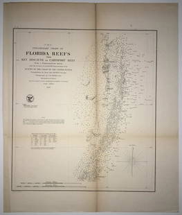
Sold2020(F No.4) Preliminary Chart of Florida Reefs from KeyTitle/Content of Map: (F No.4) Preliminary Chart of Florida Reefs from Key Biscayne to Carysfort Reef... Publication Date: 1855 Cartographer: Totten, Jas./I. Hull Adams Publisher: U.S. Coast Survey DeSee Sold Price
Sold2017SDUK: Antique Map of US Gulf Coast, 1846Title/Content of Map: 'NORTH AMERICA, SHEET XIII., Parts of Louisiana, Arkansas, Mississippi, Alabama & Florida' Native American settlements are named on the map west of the Mississippi, some marked wSee Sold Price
Sold2023USC&GS Map, Chatham River to Clam Pass, U.S Gulf CoastA map of the Gulf Coast of Florida from Chatham River to Clam Pass shown in feet. Publishing stamp by "The U.S Coast and Geodetic Survey" located on bottom. Issued: 1931 Dimensions: 43.5"L x 3See Sold Price
Sold2023USC&GS Map, Chatham River to Clam Pass, U.S Gulf CoastA map of the Gulf Coast of Florida from Chatham River to Clam Pass shown in feet. Publishing stamp by "The U.S Coast and Geodetic Survey" located on bottom. Issued: 20th Century Dimensions: 43See Sold Price
Sold2019US GULF COAST Louisiana Mississippi Alabama FloridaTITLE/CONTENT OF MAP: 'NORTH AMERICA, SHEET XIII., Parts of Louisiana, Arkansas, Mississippi, Alabama, Florida' DATE PRINTED: 1874 IMAGE SIZE: Approx 32.5 x 42.0cm, 12.75 x 16.5 inches (Large) TYPE: ASee Sold Price
Sold2024USC&GS Map, Elliot Key to Florida Bay, Intercoastal WaterwayTitle "USC&GS Map, Elliot Key to Florida Bay, Florida Intercoastal Waterway" Depicts a color map of the Intracoastal Waterway from Key Elliot to the Florida Bay. Publishing stamp by "The U.S Coast andSee Sold Price
Sold2024USC&GS Map, Barnes Sound to Key West, Intercoastal WaterwayTitle "USC&GS Map, Barnes Sound to Key West, Florida Intercoastal Waterway". Depicts a color map of the Intracoastal Waterway from Barnes Sound to Key West. Publishing stamp by "The U.S Coast and GeodSee Sold Price
Sold2023USC&GS Map, Fowey Rocks to American Shoal, Florida KeysA color map showing the land and sea area of Fowey Rocks to American Shoal. Publishing stamp by "The U.S Coast and Geodetic Survey" located on bottom. Issued: 1940 Dimensions: 38.5"L x 34"W MaSee Sold Price
Sold2023USC&GS Map, Fowey Rocks to American Shoal, Florida KeysA color map showing the land and sea area of Fowey Rocks to American Shoal. Publishing stamp by "The U.S Coast and Geodetic Survey" located on bottom. Issued: 1940 Dimensions: 38.5"L x 34"W MaSee Sold Price
Sold2020(Sketch F, No.5) Preliminary Chart of Key West HarborTitle/Content of Map: (Sketch F, No.5) Preliminary Chart of Key West Harbor and Approaches... 1851 Publication Date: 1851 Cartographer: KNORR, E. K./ISSAC HULL ADAMS Publisher: U.S. COAST SURVEY DescrSee Sold Price
Sold2024DOC Map, Florida Bay, United StatesA map of the Florida Bay and Key Largo with their surrounding areas on one side. On the reverse side is a map of Miami and Biscayne Bay along with information of that time. Publishing stamp by "U.S DeSee Sold Price
Sold2017Hand-Colored Lithograph Map of the Gulf of MexicoImpressive Hand-Colored Lithograph Map of the Gulf of Mexico, titled "U.S. Coast Survey, A.D. Bache Superintendent, Sketch H, Showing the Progress of the Survey in Section No. 8, 1846-1854", the map iSee Sold Price
Sold2019U S Coast Survey 1896 LG Map. New Orleans Texas Florida"Sketch of General Progress June 30. 1896" Showing Southern, Eastern and Mid West States, incl Florida, Texas, Gulf of Mexico, Georgia etc. Large Lithograph Map Published 1896, Washington for "U.S. CoSee Sold Price
Sold20231853 U.S. Coast Survey Map of New Orleans1853 U.S. Coast Survey Map of New Orleans, Lake Pontchartrain and the Mississippi Delta hand-colored lithograph, inscribed "U.S. Coast Survey, A. D. Bache Superintendent, Sketch H, Showing the progresSee Sold Price
Sold2021US Coast Survey Map of the Louisiana CoastAntique US Coast Survey Map of the Louisiana Coast , "U.S. Coast Survey, A.D. Bache, Superintendent", 1855, lithograph, with later hand-coloring, showing Vermillion Bay, LA to Mobile Bay, AL, sight 15See Sold Price
Sold2018Pear Shaped Diamond RingLady's 14kt white gold ring with a .76Ct pear shaped diamond, Clarity SI 2, Color F, EGL certificate US 50902701D surround by a double halo of round brilliant cut diamonds, 1.01Ctw, Clarity VS 2 - SISee Sold Price
2 days LeftSimpson Galleries, LLC.JULIUS BIEN (1826-1909) AN AMERICAN CIVIL WAR RECONNAISSANCE MAP, "Map of Texas and Part of New$100
Jun 23East Coast Fine Arts LLC1777 US Revolutionary War Map French Brion de la Tour Theatre de Guerre$1,000
Jun 15Crescent City Auction GalleryBunny Matthews (American/Louisiana, 1951-2021), "Gulf Coast Blues," 1986, H.- 11 1/4 in., W.- 15 1/2$600
738 Lots AwayKey Date Coins20 Great Coins of the World, hand selected, many trend high, every lot guaranteed to contain Silver.$15
Jun 23Schilb Antiquarian Rare Books1877 Geology Geography Surveys 1ed Nevada Wyoming Utah George Wheeler US West 2v$1(1 bid)
7 days LeftUniques and Antiques, Inc.6pcs Mid Century David Stewart Stoneware Glazed Ceramic Animal Planters. Alligator, ant eater, hippo$75(1 bid)
Jul 06Case Antiques, Inc. Auctions & AppraisalsColton's Atlas of the World, 1856, in Two Volumes; plus Africa / Mahdist War Map$500