Sold2020Indian Territory 1891Title/Content of Map: Indian Territory 1891 Date Printed: 1891 Material/Medium: Paper Size: approx 10.5x14.5 inches Additional Info: Cram's Atlas of the World. Geo. F. Cram, Chicago Reserve: $20.00 SSee Sold Price
Sold2020Indian Territory 1897Title/Content of Map: Indian Territory 1897 Date Printed: 1897 Material/Medium: paper Size: approx. 11x 13.5 inches Additional Info: Cram's Universal Atlas Reserve: $30.00 Shipping: Domestic: Flat-ratSee Sold Price
Sold2021Government map of Indian TerritoriesHeading: (Indian Territory) Author: Dinsmore, A. F., Lowe, R.P., Naylor, William, Cartographers Title: Indian Territory. Department of The Interior General Land Office. Hon. Thomas H. Carter, CommissiSee Sold Price
Sold20181890 Census Office Map of Indian Territory and OklahomaTitle/Content of Map: 1890 Census Office Map of Indian Territory and Oklahoma -- Map of Indian Territory and Oklahoma Date: 1890, Washington Cartographer: General Land Office / Census Office Size: 22.See Sold Price
Sold202119th C. Map of Indian Territory & 20th C. Kachina**Originally Listed At $300** Map: "Map of Indian Territory Drawn and Engraved on Copper Plate Expressly for Johnson's Cyclopedia" - Volume IV New York - A.J. Johnson Company, ca. 1880 to 1894. FigureSee Sold Price
Sold2021Scarce map of Indian Territory, 1886Most likely the final map of Indian Territory produced by the Colton firm. Map is colored by Indian Nations, and shows a massive Cheyennes and Arapahoes Nation at the top. Over two dozen Native AmericSee Sold Price
Sold2020Map of Indian TerritoryTitle/Content of Map: Map of Indian Territory Date: 1899 Cartographer: U.S. GEOLOGICAL SURVEY Publisher: U.S.G.S. Size: 32.5Height - 29.5Width showing distribution of woodland. Compiled under the direSee Sold Price
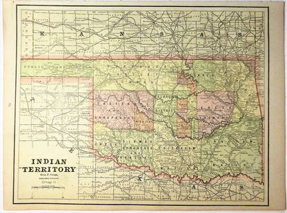
Sold2021Map of Indian Territory & KansasMap of Indian Territory Combined with Map of Kansas on Verso Color Map Dated: 19th century Dimensions: 10 x 6 1/2" Condition Report Good. TextSee Sold Price
Sold2016Map of Indian Territory and Oklahoma, J. Bein 1890Title: Map of Indian Territory and Oklahoma Subject: Oklahoma Maker: J. Bein Date: 1890, New York Size: 22.5 x 29.5 inches Map of the Indian Territory showing areas ceded to various tribes, each withSee Sold Price
Sold20181883 General Land Office Map of Indian TerritoryTitle/Content of Map: 1883 General Land Office Map of Indian Territory -- Indian Territory Date Printed: 1883, Washington Cartographer: General Land Office Size: 12 x 16 in. This is a highly detailedSee Sold Price
Sold2018Asher & Adams: Antique Map of Indian Territory, 1874Title/Content of Map: 1874 Asher & Adams Indian Territory Map -- Asher & Adams Indian Territory and Texas North West Portion Date Printed: 1874, New York Cartographer: Asher & Adams Size: 16.3 x 23.2See Sold Price
Sold2017Asher & Adams: Map of Indian Territory, 1874Map: Hand Colored Map of Indian Terratory Maker: Asher & Adams Date: 1874 Size: Approx. 16x22 inches First edition of this large format railroad map of IndianTerritory, from Asher & Adams' Atlas of thSee Sold Price
Sold2017G.P Strum: Antique Map of Indian Territory, 1883Title: Map of Indian Territory by G.P Strum Date: 1883 Medium: Lithograph Dimensions (in): 33.5 x 25.5 Condition: Great Condition No Reserve: This lot starts at $1 and has no reserve as a courtesy soSee Sold Price
Sold20181887 Mitchell Map od Indian Territory -- IndianTitle/Content of Map: 1887 Mitchell Map od Indian Territory -- Indian Territory Date: 1887, Philadelphia Cartographer: S Mitchell Size: 11.6 x 14.5 in. A very nice map of the Indian Territories, but oSee Sold Price
Sold2017Rand McNally: Map of Indian Territory, 1882Indian Territory, Rand McNally, 1882. 13 x 19.25 inches. Signature map of Indian Territory from the exceedingly hard to find 1882 version of McNally’s Indexed Atlas of the World. Highly detailed witSee Sold Price
Sold2018Handcolor map of Indian Territory - 1886Reserve Reduced! Finely engraved map that does not include the Public Lands of the panhandle. Filled with details of watershed, towns and villages, railroads, forts, military reservations, etc. DelineSee Sold Price
Sold2016Gray's Atlas Map of Indian Territory, 1875Map: Gray's Atlas Map of Indian Territory Cartographer: F Gray Publishing: Philadelphia, 1875 Size: 11.8 x 14.8 inches This very nice map shows the resettlement location for the Indian tribes, includiSee Sold Price
Sold2017Cram: Antique Map of Indian Territory, 1891Map: Indian Territory Date: 1891 From Cram's "Unrivaled Family Atlas of the World Indexed" Size: 14.5 x 11 inches George F. Cram (1842-1928) served in the U.S. Army during the American Civil War. AfteSee Sold Price
Sold2016Antique Map : Oklahoma Indian Territory - 1903Antique Map : Oklahoma Indian Territory - 1903. Size : 21.5" x 13.5"See Sold Price
Sold2017Cram: Map of Indian Territory, 1889An original map published in 1889 depicting the Indian Reservations in what is now the state of Oklahoma. 9.5 x 12" Please note that this lot has a reserve. When you leave a bid in advance of the auctSee Sold Price
Sold2023Two Antique Maps of Indian Territories British America Far WestTwo Antique Maps of Indian Territories British America Far West MEDIUM: Published Printing DIMENSIONS: Framed 18 x 27 inches DESCRIPTION: These early antique maps of British America show Districts, InSee Sold Price
Sold2021Very scarce Indian Territory/Texas, Cram 1882Scarce two-page, hand-colored map of Indian Territory and Northern Texas from the very early and scarce 1882 Cram’s Unrivaled Family Atlas of the World. All Cram atlases prior to 1883 are extremSee Sold Price
Sold20171882 Historical Hand Atlas, H. H. Hardesty Map1882 Historical Hand Atlas Illustrated, H. H. Hardesty 11.5 X 15. This Hard-to-find Atlas Has Been Rebound—it Will Look Great on Your Shelf. Several State Maps (texas/indian Territory, California/laSee Sold Price
Jun 12Dan Morphy AuctionsPLATE CXIII. MAP OF INDIAN TERRITORY SHOWING DISTRIBUTION OF WOODLAND” FROM THE TWENTY-FIRST$100
4 days LeftHolabird Western Americana CollectionsIndian Territory Map by Donaldson, 1883 [181628]$100
Jun 12Dan Morphy AuctionsMAP OF THE CHOCTAW NATION, INDIAN TERRITORY - COAL AND ASPHALT SEGREGATION 1903$150
Jun 12Dan Morphy AuctionsMAP OF THE CHOCTAW NATION, INDIAN TERRITORY - COAL AND ASPHALT SEGREGATION 1903$100
Jun 12Dan Morphy AuctionsINDIAN TERRITORY - DEPARTMENT OF THE INTERIOR GENERAL LAND OFFICE, C.1883$100(1 bid)
4 days LeftHolabird Western Americana CollectionsSouthern Kansas RWY Co. of Texas Pass, 1890 [176575]$50
4 days LeftHolabird Western Americana CollectionsEarly French Map of East Coast & Canada [179301]$200
5 days LeftTrillium Antique Prints & Rare BooksSanson - Map of California as an Island, Mexico (Audience de Guadalajara)$160(4 bids)
5 days LeftTrillium Antique Prints & Rare BooksSanson - Map of North America with California as an Island$120(3 bids)
5 days LeftTrillium Antique Prints & Rare BooksSanson - Map of Moluccas, Celebes, & Gilolo (Halmahera)$75
4 days LeftFreeman's | HindmanYOUNGBLOOD, Charles L. Adventures of... During Ten Years on the Plains. 1882. FIRST EDITION.$200(1 bid)


![Wah To Yah & The Taos Trail [181869] (1 of 5)](https://p1.liveauctioneers.com/2699/331494/178785312_1_x.jpg?height=282&quality=70&version=1717094654)
![Indian Territory Map by Donaldson, 1883 [181628] (1 of 1)](https://p1.liveauctioneers.com/2699/331495/178785757_1_x.jpg?height=282&quality=70&version=1717094933)


![Southern Kansas RWY Co. of Texas Pass, 1890 [176575] (1 of 2)](https://p1.liveauctioneers.com/2699/331495/178786165_1_x.jpg?height=282&quality=70&version=1717094933)
![British Plantation Map of the Americas [179303] (1 of 1)](https://p1.liveauctioneers.com/2699/331495/178785748_1_x.jpg?height=282&quality=70&version=1717094933)
![North America Map circa 1800s [179302] (1 of 1)](https://p1.liveauctioneers.com/2699/331495/178785793_1_x.jpg?height=282&quality=70&version=1717094933)
![Maps of Asia & India, c1800's (2) [180164] (1 of 2)](https://p1.liveauctioneers.com/2699/331495/178785787_1_x.jpg?height=282&quality=70&version=1717094933)
![Early French Map of East Coast & Canada [179301] (1 of 1)](https://p1.liveauctioneers.com/2699/331495/178785745_1_x.jpg?height=282&quality=70&version=1717094933)


![Jacob Monk 1853 Map of North America [173506] (1 of 11)](https://p1.liveauctioneers.com/2699/331495/178785775_1_x.jpg?height=282&quality=70&version=1717094933)


![Apache Geronimo Photograph c1900 [182357] (1 of 1)](https://p1.liveauctioneers.com/2699/331494/178785235_1_x.jpg?height=282&quality=70&version=1717094654)
