Sold2021Map of Indian Territory & KansasMap of Indian Territory Combined with Map of Kansas on Verso Color Map Dated: 19th century Dimensions: 10 x 6 1/2" Condition Report Good. TextSee Sold Price
Sold2017Lloyd: Map of Kansas and Other Territories, 1872Map: Kansas, and the Territories of Arizona, Colorado, New Mexico, Utah and Indian Territory (antique map) Cartographer: H.H. Lloyd Publisher: Stedman, Brown & Lyon Date: 1872 Size: 15.375 x 24.5 inchSee Sold Price
Sold20201892 Cowles Post Civil War Map of Kansas, Colorado,Title: 1892 Cowles Post Civil War Map of Kansas, Colorado, Parts of Indian Territory, Texas and New Mexico -- Map of the States of Kansas, Texas, and Indian Territory with parts of Territories of ColoSee Sold Price
Sold20201869 Mitchell Map of Plains States and Colorado --Title/Content of Map: 1869 Mitchell Map of Plains States and Colorado -- XVIII Kansas, Colorado, New Mexico and Indian Territory [verso] XVI Minnesota and Dakota [also] XVII Nebraska Cartographer: S MSee Sold Price
Sold2022Scarce map of Indian Terr., Kansas, Missouri, IllinoisScarce map of a cross section of American states and hand-colored by county at the time of publishing. Shows Oklahoma Territory when it was inhabited mostly by Native American tribes. Shows forts, raiSee Sold Price
Sold2015TAINTOR BROS. & MERRILL, (American, 19th century),TAINTOR BROS. & MERRILL (American, 19th century) Texas, Indian Territory, Kansas, New Mexico and Arizona Hand colored engraving Depicting cities and counties of Texas, Oklahoma, Kansas, New Mexico andSee Sold Price
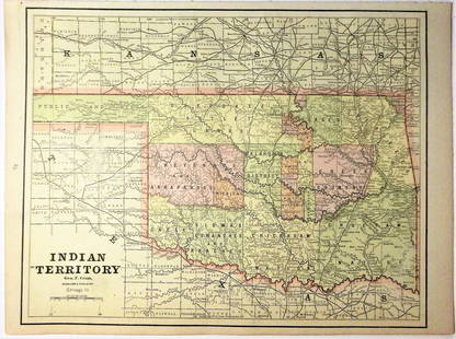
Sold2020Indian Territory 1891Title/Content of Map: Indian Territory 1891 Date Printed: 1891 Material/Medium: Paper Size: approx 10.5x14.5 inches Additional Info: Cram's Atlas of the World. Geo. F. Cram, Chicago Reserve: $20.00 SSee Sold Price
Sold2020Indian Territory 1897Title/Content of Map: Indian Territory 1897 Date Printed: 1897 Material/Medium: paper Size: approx. 11x 13.5 inches Additional Info: Cram's Universal Atlas Reserve: $30.00 Shipping: Domestic: Flat-ratSee Sold Price
Sold2021Government map of Indian TerritoriesHeading: (Indian Territory) Author: Dinsmore, A. F., Lowe, R.P., Naylor, William, Cartographers Title: Indian Territory. Department of The Interior General Land Office. Hon. Thomas H. Carter, CommissiSee Sold Price
Sold20181890 Census Office Map of Indian Territory and OklahomaTitle/Content of Map: 1890 Census Office Map of Indian Territory and Oklahoma -- Map of Indian Territory and Oklahoma Date: 1890, Washington Cartographer: General Land Office / Census Office Size: 22.See Sold Price
Sold202119th C. Map of Indian Territory & 20th C. Kachina**Originally Listed At $300** Map: "Map of Indian Territory Drawn and Engraved on Copper Plate Expressly for Johnson's Cyclopedia" - Volume IV New York - A.J. Johnson Company, ca. 1880 to 1894. FigureSee Sold Price
Sold2022Indian Territory, Missouri, Kansas & Oklahoma Railroad Ephemera [151542]Lot of 80. Too many companies and locations to mention all. Many tickets: Broken Arrow IT, Welch IT, Muskogee IT, Dacoma OK, Winona MO, Miami OK, Kansas City, Waconer IT, etc. One 1891 employee time pSee Sold Price
Sold2021Scarce map of Indian Territory, 1886Most likely the final map of Indian Territory produced by the Colton firm. Map is colored by Indian Nations, and shows a massive Cheyennes and Arapahoes Nation at the top. Over two dozen Native AmericSee Sold Price
Sold2020Map of Indian TerritoryTitle/Content of Map: Map of Indian Territory Date: 1899 Cartographer: U.S. GEOLOGICAL SURVEY Publisher: U.S.G.S. Size: 32.5Height - 29.5Width showing distribution of woodland. Compiled under the direSee Sold Price
Sold2016Map of Indian Territory and Oklahoma, J. Bein 1890Title: Map of Indian Territory and Oklahoma Subject: Oklahoma Maker: J. Bein Date: 1890, New York Size: 22.5 x 29.5 inches Map of the Indian Territory showing areas ceded to various tribes, each withSee Sold Price
Sold20181883 General Land Office Map of Indian TerritoryTitle/Content of Map: 1883 General Land Office Map of Indian Territory -- Indian Territory Date Printed: 1883, Washington Cartographer: General Land Office Size: 12 x 16 in. This is a highly detailedSee Sold Price
Sold2018Asher & Adams: Antique Map of Indian Territory, 1874Title/Content of Map: 1874 Asher & Adams Indian Territory Map -- Asher & Adams Indian Territory and Texas North West Portion Date Printed: 1874, New York Cartographer: Asher & Adams Size: 16.3 x 23.2See Sold Price
Sold2017Asher & Adams: Map of Indian Territory, 1874Map: Hand Colored Map of Indian Terratory Maker: Asher & Adams Date: 1874 Size: Approx. 16x22 inches First edition of this large format railroad map of IndianTerritory, from Asher & Adams' Atlas of thSee Sold Price
Sold2017G.P Strum: Antique Map of Indian Territory, 1883Title: Map of Indian Territory by G.P Strum Date: 1883 Medium: Lithograph Dimensions (in): 33.5 x 25.5 Condition: Great Condition No Reserve: This lot starts at $1 and has no reserve as a courtesy soSee Sold Price
Sold20181887 Mitchell Map od Indian Territory -- IndianTitle/Content of Map: 1887 Mitchell Map od Indian Territory -- Indian Territory Date: 1887, Philadelphia Cartographer: S Mitchell Size: 11.6 x 14.5 in. A very nice map of the Indian Territories, but oSee Sold Price
Sold2017Rand McNally: Map of Indian Territory, 1882Indian Territory, Rand McNally, 1882. 13 x 19.25 inches. Signature map of Indian Territory from the exceedingly hard to find 1882 version of McNally’s Indexed Atlas of the World. Highly detailed witSee Sold Price
Sold2018Handcolor map of Indian Territory - 1886Reserve Reduced! Finely engraved map that does not include the Public Lands of the panhandle. Filled with details of watershed, towns and villages, railroads, forts, military reservations, etc. DelineSee Sold Price
Sold2016Gray's Atlas Map of Indian Territory, 1875Map: Gray's Atlas Map of Indian Territory Cartographer: F Gray Publishing: Philadelphia, 1875 Size: 11.8 x 14.8 inches This very nice map shows the resettlement location for the Indian tribes, includiSee Sold Price
Jun 12Dan Morphy AuctionsPLATE CXIII. MAP OF INDIAN TERRITORY SHOWING DISTRIBUTION OF WOODLAND” FROM THE TWENTY-FIRST$100
6 days LeftJasper521898 Rand McNally Map of Texas [verso] Indian Territory and Oklahoma -- Texas [verso] Oklahoma and$70
Jun 12Dan Morphy AuctionsMAP OF THE CHOCTAW NATION, INDIAN TERRITORY - COAL AND ASPHALT SEGREGATION 1903$150
Jun 12Dan Morphy AuctionsMAP OF THE CHOCTAW NATION, INDIAN TERRITORY - COAL AND ASPHALT SEGREGATION 1903$100
Jun 07Freeman's | HindmanYOUNGBLOOD, Charles L. Adventures of... During Ten Years on the Plains. 1882. FIRST EDITION.$200
Featured6 days LeftJasper52Johnson's New Military Map of the United States Showing the Forts, Military Posts &C. With Enlarged$65
Jun 12Dan Morphy AuctionsINDIAN TERRITORY - DEPARTMENT OF THE INTERIOR GENERAL LAND OFFICE, C.1883$100
May 23Forum AuctionsIndia.- Laurie & Whittle (publishers) A New Map of the Jaghir Lands, on the Coast of Coromandel, The£75
12 hrs LeftPotter & Potter AuctionsSTORM, Mark. Official Texas Brags Map of North America. 194...$200(1 bid)
May 31Freeman's | HindmanSOULE, William S. (1836-1908). A group of 3 CDVs of Comanche subjects. Fort Sill, Indian Territory.$600
May 31Freeman's | HindmanSOULE, William S. (1836-1908). A group of 5 CDVs of Kiowa subjects. Fort Sill, Indian Territory. Ca$1,000
May 31Freeman's | Hindman[NATIVE AMERICANS]. Album containing 25 photographs of Native American subjects from Indian$1,500
Jun 02Tremont AuctionsEarly 20th century Native American Indian ledger drawing. Depiction of a brave on horseback. Ledger$300
May 31Freeman's | HindmanSOULE, William S. (1836-1908). A group of 4 CDVs of Wichita and Cheyenne subjects. Fort Sill, Indian$800


![1869 Mitchell Map of Plains States and Colorado --: Title/Content of Map: 1869 Mitchell Map of Plains States and Colorado -- XVIII Kansas, Colorado, New Mexico and Indian Territory [verso] XVI Minnesota and Dakota [also] XVII Nebraska Cartographer: S M](https://p1.liveauctioneers.com/5584/179983/90569362_1_x.jpg?height=310&quality=70&version=1601417445)


![Indian Territory, Missouri, Kansas & Oklahoma Railroad Ephemera [151542]: Lot of 80. Too many companies and locations to mention all. Many tickets: Broken Arrow IT, Welch IT, Muskogee IT, Dacoma OK, Winona MO, Miami OK, Kansas City, Waconer IT, etc. One 1891 employee time p](https://p1.liveauctioneers.com/2699/254720/132471799_1_x.jpg?height=310&quality=70&version=1657566291)


![1898 Rand McNally Map of Texas [verso] Indian Territory and Oklahoma -- Texas [verso] Oklahoma and (1 of 2)](https://p1.liveauctioneers.com/5584/329422/177662173_1_x.jpg?height=282&quality=70&version=1715717898)


![[NATIVE AMERICANS]. Album containing 25 photographs of Native American subjects from Indian (1 of 11)](https://p1.liveauctioneers.com/197/329785/177758598_1_x.jpg?height=282&quality=70&version=1715625218)


