Sold2021Scarce map of Indian Territory, 1886Most likely the final map of Indian Territory produced by the Colton firm. Map is colored by Indian Nations, and shows a massive Cheyennes and Arapahoes Nation at the top. Over two dozen Native AmericSee Sold Price
Sold2018Handcolor map of Indian Territory - 1886Reserve Reduced! Finely engraved map that does not include the Public Lands of the panhandle. Filled with details of watershed, towns and villages, railroads, forts, military reservations, etc. DelineSee Sold Price
Sold2021Very scarce Indian Territory/Texas, Cram 1882Scarce two-page, hand-colored map of Indian Territory and Northern Texas from the very early and scarce 1882 Cram’s Unrivaled Family Atlas of the World. All Cram atlases prior to 1883 are extremSee Sold Price
Sold20201886 Map of Oklahoma and the Indian TerritoryAuthor: Watson Title: 1886 Map of Oklahoma and the Indian Territory Medium: Ink on paper Dimensions: 14.5"X11" Map of Oklahoma and the Indian territory dated 1886. Part of Watson Universal Atlas publiSee Sold Price
Sold2022Scarce 1st ed. Northern Texas/Indian Territory, Tunison 1885Beautiful and scarce double-page chromolithographic map of Northern Texas and Indian Territory. From the 1885 edition of Tunison’s Peerless Universal Atlas of the World. WorldCat lists this atlaSee Sold Price
Sold2022Scarce railroad map of Oklahoma/Indian Territory, 1897Wonderfully preserved, large double-page map of Oklahoma during the frontier period when half of the present-day state was still called “Indian Territory.” This authentic vintage map comes from thSee Sold Price
Sold2022Scarce map of Indian Terr., Kansas, Missouri, IllinoisScarce map of a cross section of American states and hand-colored by county at the time of publishing. Shows Oklahoma Territory when it was inhabited mostly by Native American tribes. Shows forts, raiSee Sold Price
Sold2018Scarce 1875 hand-colored map of Texas by HardestyReserve Reduced! Attractive map of Texas and Indian Territory, colored by counties, from the very scarce Jones & Hamilton Historical Illustrated Atlas of the World published 1875 by H. H. Hardest. NicSee Sold Price
Sold20191886 Cram Map of Texas [verso] Indian Territory [verso]Title/Content of Map: 1886 Cram Map of Texas [verso] Indian Territory [verso] Arkansas -- Texas [verso] Indian Ty. [verso] Arkansas Date: 1882, Chicago Cartographer: G CramSize: 12 X 17 in. This is aSee Sold Price
Sold20201886 Cram Map of Texas [verso] Indian Territory [verso]Title/Content of Map: 1886 Cram Map of Texas [verso] Indian Territory [verso] Arkansas -- Texas [verso] Indian Ty. [verso] Arkansas Cartographer: G Cram /People's Publishing Co. Year/Place: 1886, ChicSee Sold Price
Sold20201886 Cram Map of Texas [verso] Indian Territory [verso]Title/Content of Map: 1886 Cram Map of Texas [verso] Indian Territory [verso] Arkansas -- Texas [verso] Indian Ty. [verso] Arkansas Date: 1886, Chicago Cartographer: G Cram Size: 12 X 17 in. This is aSee Sold Price
Sold20221886 Cram Map of Texas [verso] Indian Territory [verso] Arkansas -- Texas [verso] Indian Ty. [verso]Title: 1886 Cram Map of Texas [verso] Indian Territory [verso] Arkansas -- Texas [verso] Indian Ty. [verso] Arkansas Cartographer: G Cram Year / Place: 1886, Chicago Map Dimension (in.): 11.8 X 17 in.See Sold Price
Sold20181886 Cram Map of Texas [verso] Indian Territory [and]Reserve Reduced! Title/Content of Map: 1886 Cram Map of Texas [verso] Indian Territory [and] Arkansas -- Texas [verso] Indian Ty. [and] Arkansas Date: 1886, Chicago Cartographer: G Cram Size: 11.8 x 1See Sold Price
Sold20191886 Cram Map of Texas [verso] Indian Territory [verso]Title/Content of Map: 1886 Cram Map of Texas [verso] Indian Territory [verso] Arkansas -- Texas [verso] Indian Ty. [verso] Arkansas Date: 1882, Chicago Cartographer: G Cram Size: 12 X 17 in. This is aSee Sold Price
Sold20221st ed. near pristine McNally map of Texas & Ind. Terr., 1881Highly detailed and scarce large format railroad map, one of the best of the period. Rand, McNally & Co.’s Texas and Indian Territory, dated 1881 (first edition). This great map depicts railroadSee Sold Price
Sold2018Cram: Antique Map of Texas, 1886Title/Content of Map: 1886 Cram Map of Texas / Arkansas and Indian Territory on Verso -- Texas; Arkansas; Indian Ty. Date Printed: 1886, Chicago Cartographer: G Cram Size: 11.8 x 17 in. Handsomely detSee Sold Price
Sold2018Mississippi TerritoryTitle/Content of Map: Mississippi Territory Date: 1812 Cartographer: Arrowsmith & Lewis Size: 7.8X9.75 Scarce map of Mississippi Territory when it included Alabama. Depicts Indian tribes, paths and toSee Sold Price
Sold2020County Map of the State of Texas, 1886Excellent and detailed map of Texas colored by county and showing most of Indian Territory and New Mexico. In this map the Texas counties are still incomplete in the West. Features a large inset planSee Sold Price
Sold20191886 County & Township map of Arizona & N. Mexico byA fine example of William M. Bradley's 1886 map of Arizona and New Mexico. Shows just ten counties in Arizona Territory and thirteen in New Mexico Territory (plus Indian Reservation in upper left of sSee Sold Price
Sold2022Scarce Indian Territory Bottle Collection (8) [151697]1.) CALVIN BOTTLING/WORKS/CALVIN, I.T. Aqua, 6 1/2 inches tall and a mark on base of a H with a 3 above and 3 below the bar of the letter H. Lip chips. Case wear at base and around bottle. Black letteSee Sold Price
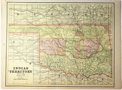
Sold2020Indian Territory 1891Title/Content of Map: Indian Territory 1891 Date Printed: 1891 Material/Medium: Paper Size: approx 10.5x14.5 inches Additional Info: Cram's Atlas of the World. Geo. F. Cram, Chicago Reserve: $20.00 SSee Sold Price
Sold2020Indian Territory 1897Title/Content of Map: Indian Territory 1897 Date Printed: 1897 Material/Medium: paper Size: approx. 11x 13.5 inches Additional Info: Cram's Universal Atlas Reserve: $30.00 Shipping: Domestic: Flat-ratSee Sold Price
Sold2021Government map of Indian TerritoriesHeading: (Indian Territory) Author: Dinsmore, A. F., Lowe, R.P., Naylor, William, Cartographers Title: Indian Territory. Department of The Interior General Land Office. Hon. Thomas H. Carter, CommissiSee Sold Price
Sold20181890 Census Office Map of Indian Territory and OklahomaTitle/Content of Map: 1890 Census Office Map of Indian Territory and Oklahoma -- Map of Indian Territory and Oklahoma Date: 1890, Washington Cartographer: General Land Office / Census Office Size: 22.See Sold Price
Jun 12Dan Morphy AuctionsPLATE CXIII. MAP OF INDIAN TERRITORY SHOWING DISTRIBUTION OF WOODLAND” FROM THE TWENTY-FIRST$100
6 days LeftJasper521898 Rand McNally Map of Texas [verso] Indian Territory and Oklahoma -- Texas [verso] Oklahoma and$70
Jun 12Dan Morphy AuctionsMAP OF THE CHOCTAW NATION, INDIAN TERRITORY - COAL AND ASPHALT SEGREGATION 1903$150
Jun 12Dan Morphy AuctionsMAP OF THE CHOCTAW NATION, INDIAN TERRITORY - COAL AND ASPHALT SEGREGATION 1903$100
Jun 02Schilb Antiquarian Rare Books1886 INDIANS 1ed Sa-Go-Ye-Wat-Ha Red Jacket Seneca Revolutionary War Hubbard$1
Featured6 days LeftJasper52Johnson's New Military Map of the United States Showing the Forts, Military Posts &C. With Enlarged$65
Jun 12Dan Morphy AuctionsINDIAN TERRITORY - DEPARTMENT OF THE INTERIOR GENERAL LAND OFFICE, C.1883$100
May 23Forum AuctionsIndia.- Laurie & Whittle (publishers) A New Map of the Jaghir Lands, on the Coast of Coromandel, The£75
3 days LeftTrillium Antique Prints & Rare BooksLinnaeus - Pair of Bird Engravings: Purple Indian Creeper & Green and Cinereous Tody$25(1 bid)
May 30Forum AuctionsIndia.- Phillimore (Colonel R. H.) Historical Records of the Survey of India, 4 vol. only (of 5),£1,000
May 31Freeman's | HindmanSOULE, William S. (1836-1908). A group of 3 CDVs of Comanche subjects. Fort Sill, Indian Territory.$600
May 31Freeman's | HindmanSOULE, William S. (1836-1908). A group of 5 CDVs of Kiowa subjects. Fort Sill, Indian Territory. Ca$1,000
May 31Freeman's | Hindman[NATIVE AMERICANS]. Album containing 25 photographs of Native American subjects from Indian$1,500


![1886 Cram Map of Texas [verso] Indian Territory [verso]: Title/Content of Map: 1886 Cram Map of Texas [verso] Indian Territory [verso] Arkansas -- Texas [verso] Indian Ty. [verso] Arkansas Date: 1882, Chicago Cartographer: G CramSize: 12 X 17 in. This is a](https://p1.liveauctioneers.com/5584/137769/69881200_1_x.jpg?height=310&quality=70&version=1552435690)
![1886 Cram Map of Texas [verso] Indian Territory [verso]: Title/Content of Map: 1886 Cram Map of Texas [verso] Indian Territory [verso] Arkansas -- Texas [verso] Indian Ty. [verso] Arkansas Cartographer: G Cram /People's Publishing Co. Year/Place: 1886, Chic](https://p1.liveauctioneers.com/5584/175972/88577718_1_x.jpg?height=310&quality=70&version=1597183226)
![1886 Cram Map of Texas [verso] Indian Territory [verso]: Title/Content of Map: 1886 Cram Map of Texas [verso] Indian Territory [verso] Arkansas -- Texas [verso] Indian Ty. [verso] Arkansas Date: 1886, Chicago Cartographer: G Cram Size: 12 X 17 in. This is a](https://p1.liveauctioneers.com/5584/161241/81395745_1_x.jpg?height=310&quality=70&version=1581460166)
![1886 Cram Map of Texas [verso] Indian Territory [verso] Arkansas -- Texas [verso] Indian Ty. [verso]: Title: 1886 Cram Map of Texas [verso] Indian Territory [verso] Arkansas -- Texas [verso] Indian Ty. [verso] Arkansas Cartographer: G Cram Year / Place: 1886, Chicago Map Dimension (in.): 11.8 X 17 in.](https://p1.liveauctioneers.com/5584/270923/141842451_1_x.jpg?height=310&quality=70&version=1670433092)
![1886 Cram Map of Texas [verso] Indian Territory [and]: Reserve Reduced! Title/Content of Map: 1886 Cram Map of Texas [verso] Indian Territory [and] Arkansas -- Texas [verso] Indian Ty. [and] Arkansas Date: 1886, Chicago Cartographer: G Cram Size: 11.8 x 1](https://p1.liveauctioneers.com/5584/128997/65616692_1_x.jpg?height=310&quality=70&version=1539125359)
![1886 Cram Map of Texas [verso] Indian Territory [verso]: Title/Content of Map: 1886 Cram Map of Texas [verso] Indian Territory [verso] Arkansas -- Texas [verso] Indian Ty. [verso] Arkansas Date: 1882, Chicago Cartographer: G Cram Size: 12 X 17 in. This is a](https://p1.liveauctioneers.com/5584/144578/73088219_1_x.jpg?height=310&quality=70&version=1561513819)


![Scarce Indian Territory Bottle Collection (8) [151697]: 1.) CALVIN BOTTLING/WORKS/CALVIN, I.T. Aqua, 6 1/2 inches tall and a mark on base of a H with a 3 above and 3 below the bar of the letter H. Lip chips. Case wear at base and around bottle. Black lette](https://p1.liveauctioneers.com/2699/254728/132473853_1_x.jpg?height=310&quality=70&version=1657577698)


![1898 Rand McNally Map of Texas [verso] Indian Territory and Oklahoma -- Texas [verso] Oklahoma and (1 of 2)](https://p1.liveauctioneers.com/5584/329422/177662173_1_x.jpg?height=282&quality=70&version=1715717898)


![[NATIVE AMERICANS]. Album containing 25 photographs of Native American subjects from Indian (1 of 11)](https://p1.liveauctioneers.com/197/329785/177758598_1_x.jpg?height=282&quality=70&version=1715625218)