Sold2016Gray's Atlas Map of Indian Territory, 1875Map: Gray's Atlas Map of Indian Territory Cartographer: F Gray Publishing: Philadelphia, 1875 Size: 11.8 x 14.8 inches This very nice map shows the resettlement location for the Indian tribes, includiSee Sold Price
Sold20221875 Gray's New Map of Texas - 1st ed.Large and impressive hand-colored map of Texas from Gray’s National Atlas. Full title: “Gray’s New Map of Texas and the Indian Territory.” Created by Frank Gray, the map hasSee Sold Price
Sold2018Scarce 1875 hand-colored map of Texas by HardestyReserve Reduced! Attractive map of Texas and Indian Territory, colored by counties, from the very scarce Jones & Hamilton Historical Illustrated Atlas of the World published 1875 by H. H. Hardest. NicSee Sold Price
Sold20211880 Gray Map of Texas and Indian Territory -- Gray'sTitle: 1880 Gray Map of Texas and Indian Territory -- Gray's New Map of Texas and the Indian Territory Cartographer: F Gray Year/Place: 1880, Philadelphia Map Dimensions (in.): 17 X 26.4 in. DescriptiSee Sold Price
Sold20191892 Watson/Cram Map of Texas [verso] Indian TerritoryTitle/Content of Map: 1892 Watson/Cram Map of Texas [verso] Indian Territory [verso] Arkansas -- Watson's Atlas Map of Texas [verso] Watson's Atlas Map of Indiand Ty. [verso] Watson's Atlas Map of ArkSee Sold Price
Sold2022Map of Texas, Indian Terr., Mississippi, etc.- OlneyNice hand-colored school atlas map of the near Southwest. “No. 8 Mississippi, Arkansas, Louisiana, Texas, Indian Territory.” From Olney’s 1849 school atlas. Clean with a tiny spot iSee Sold Price
Sold2020Indian Territory 1891Title/Content of Map: Indian Territory 1891 Date Printed: 1891 Material/Medium: Paper Size: approx 10.5x14.5 inches Additional Info: Cram's Atlas of the World. Geo. F. Cram, Chicago Reserve: $20.00 SSee Sold Price
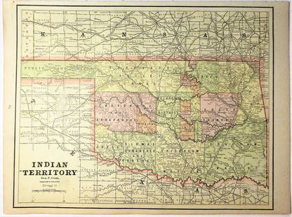
Sold2020Indian Territory 1897Title/Content of Map: Indian Territory 1897 Date Printed: 1897 Material/Medium: paper Size: approx. 11x 13.5 inches Additional Info: Cram's Universal Atlas Reserve: $30.00 Shipping: Domestic: Flat-ratSee Sold Price
Sold20171882 Historical Hand Atlas, H. H. Hardesty Map1882 Historical Hand Atlas Illustrated, H. H. Hardesty 11.5 X 15. This Hard-to-find Atlas Has Been Rebound—it Will Look Great on Your Shelf. Several State Maps (texas/indian Territory, California/laSee Sold Price
Sold2017Asher & Adams: Map of Indian Territory, 1874Map: Hand Colored Map of Indian Terratory Maker: Asher & Adams Date: 1874 Size: Approx. 16x22 inches First edition of this large format railroad map of IndianTerritory, from Asher & Adams' Atlas of thSee Sold Price
Sold20191875 Gray's Map of California and Nevada - Gray's AtlasTitle/Content of Map: 1875 Gray's Map of California and Nevada - Gray's Atlas California and Nevada Date: 1875, Philadelphia Cartographer: F Gray Size: 26.4 X 15.4 in. Very nice large size map of CaliSee Sold Price
Sold2017Rand McNally: Map of Indian Territory, 1882Indian Territory, Rand McNally, 1882. 13 x 19.25 inches. Signature map of Indian Territory from the exceedingly hard to find 1882 version of McNally’s Indexed Atlas of the World. Highly detailed witSee Sold Price
Sold2017Cram: Antique Map of Indian Territory, 1891Map: Indian Territory Date: 1891 From Cram's "Unrivaled Family Atlas of the World Indexed" Size: 14.5 x 11 inches George F. Cram (1842-1928) served in the U.S. Army during the American Civil War. AfteSee Sold Price
Sold2021Early atlas map of Louisville, Ky. By O.W. GrayClean and fine map of Louisville, Kentucky from the first edition of Gray’s National Atlas. Maps of Louisville in early atlases were usually joined with another city on the page. This 1875 example dSee Sold Price
Sold2021Very scarce Indian Territory/Texas, Cram 1882Scarce two-page, hand-colored map of Indian Territory and Northern Texas from the very early and scarce 1882 Cram’s Unrivaled Family Atlas of the World. All Cram atlases prior to 1883 are extremSee Sold Price
Sold20211873 Texas and Indian Territory MapAuthor: Bartholomew Title: 1873 Texas and Indian Territory Map Medium: Ink on Paper Dimensions: 17.5"X13" Map of Texas and the Indian Territory dated 1873. Part of Zell's Descriptive Hand Atlas of theSee Sold Price
Sold2017McNally: Map of Texas, New Mexico, Indian TerritoryMap of Texas, New Mexico and Indian Territory. McNally's System of Geography. 1875. 12 x 10 inches. Inset showing Vicinity of Galveston Please note that this lot has a confidential reserve. When you lSee Sold Price
Sold20241875 Walling and Gray Pennsylvania County Maps -- Atlas of Pennsylvania Counties of Chester,Title: 1875 Walling and Gray Pennsylvania County Maps -- Atlas of Pennsylvania Counties of Chester, Dauphin, Berks, Lebanon, York and Lancaster [with] Cumberland Fraklin and Adams Cartographer: WallinSee Sold Price
Sold2021Huge RR map of New Jersey, 1875Large county and railroad map of the Garden State from Gray’s 1875 atlas. Railroad lines are illustrated very prominently. Great detail; shows topography, towns, rivers, lakes, inlets bays, etc.See Sold Price
Sold20231875 RR map of Kentucky and Tennessee, O. W. GrayLovely hand-colored map of Kentucky and Tennessee from Gray’s 1875 National Atlas, an exceedingly difficult atlas to find. The map shows the extensive network of railroads that existed in the reSee Sold Price
Sold2022Texas, Indian Terr. and SW states, Steinwehr 1870Striking map from 1870 school atlas. Shows military posts, tribes, railroads, cities and towns in Texas, Arkansas, Mississippi, "Indian Territory," and Louisiana, and public lands. Printed color. MapSee Sold Price
Sold20201886 Map of Oklahoma and the Indian TerritoryAuthor: Watson Title: 1886 Map of Oklahoma and the Indian Territory Medium: Ink on paper Dimensions: 14.5"X11" Map of Oklahoma and the Indian territory dated 1886. Part of Watson Universal Atlas publiSee Sold Price
Sold2022Scarce 1st ed. Northern Texas/Indian Territory, Tunison 1885Beautiful and scarce double-page chromolithographic map of Northern Texas and Indian Territory. From the 1885 edition of Tunison’s Peerless Universal Atlas of the World. WorldCat lists this atlaSee Sold Price
Sold20171888 New Mexio, McNally’s Indexed Atlas of the World1888 New Mexio from McNally’s Indexed Atlas of the World. Large one-sheet map covers the Oklahoma Territory and Indian Territory prior to being admitted as a single state of Oklahoma in 1907. InsetSee Sold Price
Jun 12Dan Morphy AuctionsPLATE CXIII. MAP OF INDIAN TERRITORY SHOWING DISTRIBUTION OF WOODLAND” FROM THE TWENTY-FIRST$100
6 days LeftJasper521898 Rand McNally Map of Texas [verso] Indian Territory and Oklahoma -- Texas [verso] Oklahoma and$70
Jun 12Dan Morphy AuctionsMAP OF THE CHOCTAW NATION, INDIAN TERRITORY - COAL AND ASPHALT SEGREGATION 1903$150
Jun 12Dan Morphy AuctionsMAP OF THE CHOCTAW NATION, INDIAN TERRITORY - COAL AND ASPHALT SEGREGATION 1903$100
Featured6 days LeftJasper52Johnson's New Military Map of the United States Showing the Forts, Military Posts &C. With Enlarged$65
Jun 12Dan Morphy AuctionsINDIAN TERRITORY - DEPARTMENT OF THE INTERIOR GENERAL LAND OFFICE, C.1883$100


![1892 Watson/Cram Map of Texas [verso] Indian Territory: Title/Content of Map: 1892 Watson/Cram Map of Texas [verso] Indian Territory [verso] Arkansas -- Watson's Atlas Map of Texas [verso] Watson's Atlas Map of Indiand Ty. [verso] Watson's Atlas Map of Ark](https://p1.liveauctioneers.com/5584/133765/67935052_1_x.jpg?height=310&quality=70&version=1546475054)


![1875 Walling and Gray Pennsylvania County Maps -- Atlas of Pennsylvania Counties of Chester,: Title: 1875 Walling and Gray Pennsylvania County Maps -- Atlas of Pennsylvania Counties of Chester, Dauphin, Berks, Lebanon, York and Lancaster [with] Cumberland Fraklin and Adams Cartographer: Wallin](https://p1.liveauctioneers.com/5584/319185/171438575_1_x.jpg?height=310&quality=70&version=1707858212)


![1898 Rand McNally Map of Texas [verso] Indian Territory and Oklahoma -- Texas [verso] Oklahoma and (1 of 2)](https://p1.liveauctioneers.com/5584/329422/177662173_1_x.jpg?height=282&quality=70&version=1715717898)


