Sold2017Cram: Map of Indian Territory, 1889An original map published in 1889 depicting the Indian Reservations in what is now the state of Oklahoma. 9.5 x 12" Please note that this lot has a reserve. When you leave a bid in advance of the auctSee Sold Price
Sold2017Cram: Antique Map of Indian Territory, 1891Map: Indian Territory Date: 1891 From Cram's "Unrivaled Family Atlas of the World Indexed" Size: 14.5 x 11 inches George F. Cram (1842-1928) served in the U.S. Army during the American Civil War. AfteSee Sold Price
Sold20191886 Cram Map of Texas [verso] Indian Territory [verso]Title/Content of Map: 1886 Cram Map of Texas [verso] Indian Territory [verso] Arkansas -- Texas [verso] Indian Ty. [verso] Arkansas Date: 1882, Chicago Cartographer: G CramSize: 12 X 17 in. This is aSee Sold Price
Sold20201886 Cram Map of Texas [verso] Indian Territory [verso]Title/Content of Map: 1886 Cram Map of Texas [verso] Indian Territory [verso] Arkansas -- Texas [verso] Indian Ty. [verso] Arkansas Cartographer: G Cram /People's Publishing Co. Year/Place: 1886, ChicSee Sold Price
Sold20201887 Cram Map of Texas [verso] Indian Territory [verso]Title/Content of Map: 1887 Cram Map of Texas [verso] Indian Territory [verso] Arkansas -- Texas [verso] Indian Ty. [verso] Arkansas Date: 1887, Chicago Cartographer: G Cram Size: 12 X 17 in. This is aSee Sold Price
Sold20201886 Cram Map of Texas [verso] Indian Territory [verso]Title/Content of Map: 1886 Cram Map of Texas [verso] Indian Territory [verso] Arkansas -- Texas [verso] Indian Ty. [verso] Arkansas Date: 1886, Chicago Cartographer: G Cram Size: 12 X 17 in. This is aSee Sold Price
Sold20221886 Cram Map of Texas [verso] Indian Territory [verso] Arkansas -- Texas [verso] Indian Ty. [verso]Title: 1886 Cram Map of Texas [verso] Indian Territory [verso] Arkansas -- Texas [verso] Indian Ty. [verso] Arkansas Cartographer: G Cram Year / Place: 1886, Chicago Map Dimension (in.): 11.8 X 17 in.See Sold Price
Sold20231884 Cram Map of Texas [verso] Indian Territory [verso] Arkansas -- Texas [verso] Indian Ty. [verso]Title: 1884 Cram Map of Texas [verso] Indian Territory [verso] Arkansas -- Texas [verso] Indian Ty. [verso] Arkansas Cartographer: G Cram Year / Place: 1884, Chicago Map Dimension (in.): 11.8 X 17 in.See Sold Price
Sold2017Cram: Antique Map of Texas, Indian Territory, ArkansasTitle/Content of Map: 1885 Cram Map of Texas, [verso] Indian Territory and Arkansas -- Texas, [verso] Indian Ty; Arkansas Date Printed: 1885, Chicago Cartographer: G Cram Size: 12 x 17 in. This is a nSee Sold Price
Sold20181886 Cram Map of Texas [verso] Indian Territory [and]Reserve Reduced! Title/Content of Map: 1886 Cram Map of Texas [verso] Indian Territory [and] Arkansas -- Texas [verso] Indian Ty. [and] Arkansas Date: 1886, Chicago Cartographer: G Cram Size: 11.8 x 1See Sold Price
Sold20191886 Cram Map of Texas [verso] Indian Territory [verso]Title/Content of Map: 1886 Cram Map of Texas [verso] Indian Territory [verso] Arkansas -- Texas [verso] Indian Ty. [verso] Arkansas Date: 1882, Chicago Cartographer: G Cram Size: 12 X 17 in. This is aSee Sold Price
Sold20221902 Cram Map of Oklahoma and Indian TerritoriesTitle: 1902 Cram Map of Oklahoma and Indian Territories [verso] New Mexico -- Oklahoma and Indian Territories [verso] New Mexico Cartographer: G Cram Year/Place: 1902, Chicago Dimensions: 9.5 X 12.8 iSee Sold Price
Sold20191892 Watson/Cram Map of Texas [verso] Indian TerritoryTitle/Content of Map: 1892 Watson/Cram Map of Texas [verso] Indian Territory [verso] Arkansas -- Watson's Atlas Map of Texas [verso] Watson's Atlas Map of Indiand Ty. [verso] Watson's Atlas Map of ArkSee Sold Price
Sold2018Cram: Antique Map of Texas, 1886Title/Content of Map: 1886 Cram Map of Texas / Arkansas and Indian Territory on Verso -- Texas; Arkansas; Indian Ty. Date Printed: 1886, Chicago Cartographer: G Cram Size: 11.8 x 17 in. Handsomely detSee Sold Price
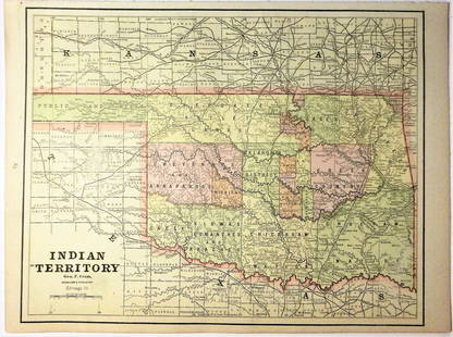
Sold20201889 Map of Oklahoma and the Indian TerritoryAuthor: Watson Title: 1889 Map of Oklahoma and the Indian Territory Medium: Ink on Paper Dimensions: 14.5"X11" Map of Oklahoma and the Indian Territory dated 1889. Published by Watson in Chicago. KeySee Sold Price
Sold20201889 Map of Oklahoma and the Indian TerritoryAuthor: Watson Title: 1889 Map of Oklahoma and the Indian Territory Medium: Ink on paper Dimensions: 14.5"X11" Description: Map of Oklahoma and the Indian Territory dated 1889. Printed and published bSee Sold Price
Sold2020Indian Territory 1891Title/Content of Map: Indian Territory 1891 Date Printed: 1891 Material/Medium: Paper Size: approx 10.5x14.5 inches Additional Info: Cram's Atlas of the World. Geo. F. Cram, Chicago Reserve: $20.00 SSee Sold Price
Sold2020Indian Territory 1897Title/Content of Map: Indian Territory 1897 Date Printed: 1897 Material/Medium: paper Size: approx. 11x 13.5 inches Additional Info: Cram's Universal Atlas Reserve: $30.00 Shipping: Domestic: Flat-ratSee Sold Price
Sold2021Very scarce Indian Territory/Texas, Cram 1882Scarce two-page, hand-colored map of Indian Territory and Northern Texas from the very early and scarce 1882 Cram’s Unrivaled Family Atlas of the World. All Cram atlases prior to 1883 are extremSee Sold Price
Sold2020ARBUCKLES INDIAN TERRITORY MAP, C.1889Framed colorful card map of the Indian Territory, illustrated with bison, Indians and accoutrements, a chromolithograph, patent date 1889, given as a premium with Arbuckle Brothers coffee and publisheSee Sold Price
Sold20201883 Map of the Indian TerritoryAuthor: Cram Title: 1883 Map of the Indian Territory Medium: Ink on Paper Dimensions: 13.5"X11" Map of the Indian Territory dated 1883. Engraved and published by George Cram in Chicago. Key lower leftSee Sold Price
Sold2021Large Map of Oklahoma & Indian TerritoriesMap of Oklahoma & Indian Territories With map of New Mexico on verso Cartographer: George Franklin Cram Dated: Circa 1900 Type: Color LithographSee Sold Price
Sold2019George Cram’s "Rail Road Map, Texas and IndianGeorge Cram’s "Rail Road Map, Texas and Indian Territory," 1900, H.- 18 3/8 in., W.- 26 3/4 in.See Sold Price
Sold20201892 Map of Oklahoma and the Indian TerritoryAuthor: Cram Title: 1892 Map of Oklahoma and the Indian Territory Medium: Ink on Paper Dimensions: 21.5"X14.5" Map of Oklahoma and the Indian territory dated 1892. Engraved and published by George CraSee Sold Price
21 hrs LeftJasper521887 Cram Map of Texas [verso] Indian Territory [verso] Arkansas -- Texas [verso] Indian Ty. [verso]$95
Jun 12Dan Morphy AuctionsPLATE CXIII. MAP OF INDIAN TERRITORY SHOWING DISTRIBUTION OF WOODLAND” FROM THE TWENTY-FIRST$100
21 hrs LeftJasper521898 Rand McNally Map of Texas [verso] Indian Territory and Oklahoma -- Texas [verso] Oklahoma and$70
Jun 12Dan Morphy AuctionsMAP OF THE CHOCTAW NATION, INDIAN TERRITORY - COAL AND ASPHALT SEGREGATION 1903$150
Jun 12Dan Morphy AuctionsMAP OF THE CHOCTAW NATION, INDIAN TERRITORY - COAL AND ASPHALT SEGREGATION 1903$100
Jun 12Dan Morphy AuctionsINDIAN TERRITORY - DEPARTMENT OF THE INTERIOR GENERAL LAND OFFICE, C.1883$100
21 hrs LeftJasper521896 Cram Comparison of Tall Buildings Globally -- Diagram of the Principal High Buildings of the$70
May 31Freeman's | HindmanSOULE, William S. (1836-1908). A group of 3 CDVs of Comanche subjects. Fort Sill, Indian Territory.$600
21 hrs LeftJasper521890s Cram Map of Vermont [verso] New Hampshire -- Vermont [verso] New Hampshire$30
May 31Freeman's | HindmanSOULE, William S. (1836-1908). A group of 5 CDVs of Kiowa subjects. Fort Sill, Indian Territory. Ca$1,000
May 31Freeman's | HindmanSOULE, William S. (1836-1908). A group of 4 CDVs of Wichita and Cheyenne subjects. Fort Sill, Indian$800
May 31Freeman's | Hindman[NATIVE AMERICANS]. Album containing 25 photographs of Native American subjects from Indian$1,500


![1886 Cram Map of Texas [verso] Indian Territory [verso]: Title/Content of Map: 1886 Cram Map of Texas [verso] Indian Territory [verso] Arkansas -- Texas [verso] Indian Ty. [verso] Arkansas Date: 1882, Chicago Cartographer: G CramSize: 12 X 17 in. This is a](https://p1.liveauctioneers.com/5584/137769/69881200_1_x.jpg?height=310&quality=70&version=1552435690)
![1886 Cram Map of Texas [verso] Indian Territory [verso]: Title/Content of Map: 1886 Cram Map of Texas [verso] Indian Territory [verso] Arkansas -- Texas [verso] Indian Ty. [verso] Arkansas Cartographer: G Cram /People's Publishing Co. Year/Place: 1886, Chic](https://p1.liveauctioneers.com/5584/175972/88577718_1_x.jpg?height=310&quality=70&version=1597183226)
![1887 Cram Map of Texas [verso] Indian Territory [verso]: Title/Content of Map: 1887 Cram Map of Texas [verso] Indian Territory [verso] Arkansas -- Texas [verso] Indian Ty. [verso] Arkansas Date: 1887, Chicago Cartographer: G Cram Size: 12 X 17 in. This is a](https://p1.liveauctioneers.com/5584/164510/83043299_1_x.jpg?height=310&quality=70&version=1585094571)
![1886 Cram Map of Texas [verso] Indian Territory [verso]: Title/Content of Map: 1886 Cram Map of Texas [verso] Indian Territory [verso] Arkansas -- Texas [verso] Indian Ty. [verso] Arkansas Date: 1886, Chicago Cartographer: G Cram Size: 12 X 17 in. This is a](https://p1.liveauctioneers.com/5584/161241/81395745_1_x.jpg?height=310&quality=70&version=1581460166)
![1886 Cram Map of Texas [verso] Indian Territory [verso] Arkansas -- Texas [verso] Indian Ty. [verso]: Title: 1886 Cram Map of Texas [verso] Indian Territory [verso] Arkansas -- Texas [verso] Indian Ty. [verso] Arkansas Cartographer: G Cram Year / Place: 1886, Chicago Map Dimension (in.): 11.8 X 17 in.](https://p1.liveauctioneers.com/5584/270923/141842451_1_x.jpg?height=310&quality=70&version=1670433092)
![1884 Cram Map of Texas [verso] Indian Territory [verso] Arkansas -- Texas [verso] Indian Ty. [verso]: Title: 1884 Cram Map of Texas [verso] Indian Territory [verso] Arkansas -- Texas [verso] Indian Ty. [verso] Arkansas Cartographer: G Cram Year / Place: 1884, Chicago Map Dimension (in.): 11.8 X 17 in.](https://p1.liveauctioneers.com/5584/304136/162284641_1_x.jpg?height=310&quality=70&version=1696356363)
![Cram: Antique Map of Texas, Indian Territory, Arkansas: Title/Content of Map: 1885 Cram Map of Texas, [verso] Indian Territory and Arkansas -- Texas, [verso] Indian Ty; Arkansas Date Printed: 1885, Chicago Cartographer: G Cram Size: 12 x 17 in. This is a n](https://p1.liveauctioneers.com/5584/113749/58452563_1_x.jpg?height=310&quality=70&version=1513734097)
![1886 Cram Map of Texas [verso] Indian Territory [and]: Reserve Reduced! Title/Content of Map: 1886 Cram Map of Texas [verso] Indian Territory [and] Arkansas -- Texas [verso] Indian Ty. [and] Arkansas Date: 1886, Chicago Cartographer: G Cram Size: 11.8 x 1](https://p1.liveauctioneers.com/5584/128997/65616692_1_x.jpg?height=310&quality=70&version=1539125359)
![1886 Cram Map of Texas [verso] Indian Territory [verso]: Title/Content of Map: 1886 Cram Map of Texas [verso] Indian Territory [verso] Arkansas -- Texas [verso] Indian Ty. [verso] Arkansas Date: 1882, Chicago Cartographer: G Cram Size: 12 X 17 in. This is a](https://p1.liveauctioneers.com/5584/144578/73088219_1_x.jpg?height=310&quality=70&version=1561513819)
![1902 Cram Map of Oklahoma and Indian Territories: Title: 1902 Cram Map of Oklahoma and Indian Territories [verso] New Mexico -- Oklahoma and Indian Territories [verso] New Mexico Cartographer: G Cram Year/Place: 1902, Chicago Dimensions: 9.5 X 12.8 i](https://p1.liveauctioneers.com/5584/235407/121906565_1_x.jpg?height=310&quality=70&version=1643755752)
![1892 Watson/Cram Map of Texas [verso] Indian Territory: Title/Content of Map: 1892 Watson/Cram Map of Texas [verso] Indian Territory [verso] Arkansas -- Watson's Atlas Map of Texas [verso] Watson's Atlas Map of Indiand Ty. [verso] Watson's Atlas Map of Ark](https://p1.liveauctioneers.com/5584/133765/67935052_1_x.jpg?height=310&quality=70&version=1546475054)


![1887 Cram Map of Texas [verso] Indian Territory [verso] Arkansas -- Texas [verso] Indian Ty. [verso] (1 of 3)](https://p1.liveauctioneers.com/5584/328338/176911685_1_x.jpg?height=282&quality=70&version=1715113718)

![1898 Rand McNally Map of Texas [verso] Indian Territory and Oklahoma -- Texas [verso] Oklahoma and (1 of 2)](https://p1.liveauctioneers.com/5584/328338/176911581_1_x.jpg?height=282&quality=70&version=1715113718)


![1891 Cram Map of Nashville [verso] Memphis -- Nashville [verso] Memphis (1 of 2)](https://p1.liveauctioneers.com/5584/328338/176911543_1_x.jpg?height=282&quality=70&version=1715113718)

![1890s Cram Map of Vermont [verso] New Hampshire -- Vermont [verso] New Hampshire (1 of 2)](https://p1.liveauctioneers.com/5584/328338/176911596_1_x.jpg?height=282&quality=70&version=1715113718)


![(2) Comanche Portraits by Lenny & Sawyers [Cabinet Card] (1 of 2)](https://p1.liveauctioneers.com/7226/322253/173251539_1_x.jpg?height=282&quality=70&version=1710004847)


![[NATIVE AMERICANS]. Album containing 25 photographs of Native American subjects from Indian (1 of 11)](https://p1.liveauctioneers.com/197/329785/177758598_1_x.jpg?height=282&quality=70&version=1715625218)
