
 Discovery- InteriorsBonhamsSponsored.Your ad here?


Discovery- Interiors
Bonhams
Sponsored.Your ad here?


 Discovery- InteriorsBonhamsSponsored.Your ad here?


Discovery- Interiors
Bonhams
Sponsored.Your ad here?

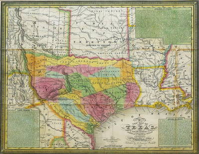
1846 Mitchell Map of Texas -- No. 13 Map of the State
Similar Sale History
View More Items in Maps & Atlases
Related Maps & Atlases
More Items in Maps & Atlases
View MoreRecommended Transportation & Travel Collectibles
View More


Item Details
Description
This is an excellent map of Texas featuring the "stovepipe" configuration, showing it at its largest extent when admitted to the Union. The map shows the western boundary at the Rio Grande del Norte, putting Santa Fe and Taos in Texas. Part of Texas continues to the northwest in an area labeled as Green Mountains. This edition is the first to name Dallas. The Santa Fe Trail is shown. Two locations and dates in 1846 of early Mexican-American War battles are shown: Battles of Palo Alto and Resaca de la Palma. There are no counties formed in the west but there is a large unorganized Bexar region above San Antonio de Bexar and below a region labeled as Wild Horses. In the western region a number of Indian tribes are named, as well as in the Indian Territory to the north. This is the most desirable map of Texas from the Mitchell school geographies series.
Reserve: $280.00
Shipping:
Your purchase is protected:
Photos, descriptions, and estimates were prepared with the utmost care by a fully certified expert and appraiser. All items in this sale are guaranteed authentic.
In the rare event that the item did not conform to the lot description in the sale, Jasper52 specialists are here to help. Buyers may return the item for a full refund provided you notify Jasper52 within 5 days of receiving the item.
Condition
Good. Slight soiling and toning, mostly in the margins. Colored.
Buyer's Premium
- 15%
1846 Mitchell Map of Texas -- No. 13 Map of the State
Estimate $350 - $400
6 bidders are watching this item.
Shipping & Pickup Options
Item located in Ohio, US$18 shipping in the US
Payment
See More Items From This Jasper52 Seller

Auction Curated By

Maps Expert
Related Searches
TOP


![[Maps] Martin Zeiler, Itinerarium Italiae, 1640: [Maps] Martin Zeiler, Itinerarium Italiae, 1640, Martini Zeilleri. Itinerarium Italiae Nov-Antiquae: oder, Raiss-Beschreibung durch Italien, Matthaus Merian, Frankfurt, 40 plates, most double-page, in](https://p1.liveauctioneers.com/188/326797/176317459_1_x.jpg?height=310&quality=70&version=1713847031)


![[Maps] Gio. Ant. Magnini, Italia, 1620: [Maps] Gio. Ant. Magnini, Italia, 1620, Giovanni Antonio Magnini. Italia, data in luce da Fabio suo figliuolo al Serenissimo Ferdinado Gonzaga Duca di Matoua edi Monserrato etc. Bologna, for Sebastian](https://p1.liveauctioneers.com/188/326797/176317457_1_x.jpg?height=310&quality=70&version=1713847031)


