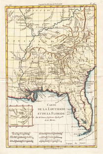
Bonne Map of Louisiana and Florida 1780
Similar Sale History
View More Items in Maps & AtlasesRelated Maps & Atlases
More Items in Maps & Atlases
View MoreRecommended Transportation & Travel Collectibles
View More


Item Details
Description
Rigobert Bonne (1727-1795), engraved by Peter Andre, "Carte de la Louisiane, et de la Floride," Paris, ca. 1780. This hand colored map depicts the southeastern United States, extending from West Virginia and Southern Illinois in the north to Florida and New Orleans in the South. With an inset showing the area around what is now Kansas City. Dimensions: Sheet; height: 13 3/4 in x width: 9 1/4 in.
SKU: 03425
Condition
Good condition, adhered with tape along the top edge, horizontal crease, and some soiling along the edges.
Buyer's Premium
- 28%
Bonne Map of Louisiana and Florida 1780
Estimate $200 - $300
5 bidders are watching this item.
Shipping & Pickup Options
Item located in St. Paul, MN, usSee Policy for Shipping
Payment

TOP


![Zatta: Antique Map of English Louisiana, Florida, 1778: Map: Luigiana Inglese, colla parte Occidentale, della Florida, della Georgia, e Carolina Merid[i]onale Cartographer: Zatta Place & Date: Venice / 1778 Size: 16 1/2" x 12 1/2" Condition: Original color](https://p1.liveauctioneers.com/5584/115725/59466799_1_x.jpg?height=310&quality=70&version=1517366277)


![Entrée de Norton & Détroit de Bhering. Bering Strait Norton Sound BONNE 1790 map: TITLE/CONTENT OF MAP: [Cook 3e Voyage] Carte de l'entrée de Norton et du Détroit de Bhering, où l'on voit le Cap le plus Oriental de l'Asie et la pointe la plus Occidentale de l'Amé](https://p1.liveauctioneers.com/5584/326888/175994368_1_x.jpg?height=310&quality=70&version=1713903186)
![Entrée de Norton & Détroit de Bhering. Bering Strait Norton Sound BONNE 1788 map: TITLE/CONTENT OF MAP: [Cook 3e Voyage] Carte de l'entrée de Norton et du Détroit de Bhering, où l'on voit le Cap le plus Oriental de l'Asie et la pointe la plus Occidentale de l'Amé](https://p1.liveauctioneers.com/5584/326888/175994363_1_x.jpg?height=310&quality=70&version=1713903186)
![Isles de la Reine Charlotte. Nendo, Santa Cruz, Solomon Islands. BONNE 1790 map: TITLE/CONTENT OF MAP: [Voyage du Capitaine Carteret] Isles de la Reine Charlotte // Isle du Lord Egmont ou Nouvelle Grenesey // Isle de Carteret // Baye de L'Hirondelle // Havre de Byron [Voyage of Ca](https://p1.liveauctioneers.com/5584/326888/175994487_1_x.jpg?height=310&quality=70&version=1713903186)
![Isles de la Reine Charlotte. Nendo, Santa Cruz, Solomon Islands. BONNE 1788 map: TITLE/CONTENT OF MAP: [Voyage du Capitaine Carteret] Isles de la Reine Charlotte // Isle du Lord Egmont ou Nouvelle Grenesey // Isle de Carteret // Baye de L'Hirondelle // Havre de Byron [Voyage of Ca](https://p1.liveauctioneers.com/5584/326888/175994471_1_x.jpg?height=310&quality=70&version=1713903186)
![Carte des Isles des Amis. Friendly or Tonga Islands. Tongatapu. BONNE 1790 map: TITLE/CONTENT OF MAP: [Cook 3e Voyage] Carte des Isles des Amis // Plan du Havre de Tongataboo // Tabouai Island // Mangeea Island // Wateeoo Island [Cook's 3rd Voyage - Map of Friendly Islands (Tonga](https://p1.liveauctioneers.com/5584/326888/175994571_1_x.jpg?height=310&quality=70&version=1713903186)
![Carte des Isles des Amis. Friendly or Tonga Islands. Tongatapu. BONNE 1788 map: TITLE/CONTENT OF MAP: [Cook 3e Voyage] Carte des Isles des Amis // Plan du Havre de Tongataboo // Tabouai Island // Mangeea Island // Wateeoo Island [Cook's 3rd Voyage - Map of Friendly Islands (Tonga](https://p1.liveauctioneers.com/5584/326888/175994486_1_x.jpg?height=310&quality=70&version=1713903186)
![Isles de la Société. Society Islands. Huaheine Raiatea Polynesia. BONNE 1788 map: TITLE/CONTENT OF MAP: [Cook 3e Voyage] Carte des Isles de la Société // Isle de Noël // Havre d'Owarre dans Huaheine // Havre d'Oopoa dans Ulietea // Havre d'Ohamaneno dans Ulietea [Coo](https://p1.liveauctioneers.com/5584/326888/175994425_1_x.jpg?height=310&quality=70&version=1713903186)


![A desirable early issue of Hondius map of Virginia and Florida: [MAP-NORTH AMERICA] MERCATOR, GERARD and HONDIUS, JOCODUS. Virginiae item et Floridae Americae Provinciarum, nova descriptio. [Amsterdam: Jodocus Hondius, 1607 or later]. Hand-colored engraved map. Wi](https://p1.liveauctioneers.com/292/326828/175962855_1_x.jpg?height=310&quality=70&version=1713473479)


