


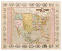
Map of the United States and Mexico, Including Oregon,
Similar Sale History
View More Items in Maps & Atlases
![Map of U.S., 1846: *** START PRICE IS THE RESERVE *** [America] HAVEN & EMMERSON. Map of the United States and Mexico Including Oregon, Texas and the Californias. Engraved map with original hand color. New York, 1846. 1](https://p1.liveauctioneers.com/1968/163248/82424576_1_x.jpg?height=310&quality=70&version=1583340284)
![United States of North America, Pacific States by Joseph Wilson Lowry 1859 map: DescriptionCAPTION PRINTED BELOW PICTURE: The United States of North America, Pacific States [including California, Oregon, Washington, Utah, and part of New Mexico, ]The map shows Washington, Oregon,](https://p1.liveauctioneers.com/5584/311630/167410815_1_x.jpg?height=310&quality=70&version=1701439692)


Related Maps & Atlases


![Rand, McNally & Co.'S New Commercial Railroad Map of the United States [Chicago to Denver]: Title: Rand, McNally & Co.'S New Commercial Railroad Map of the United States [Chicago to Denver] Cartographer: RAND, MCNALLY & CO. Publisher: RAND-MCNALLY & CO. Dimensions: Height: 26 Width: 18.5 Des](https://p1.liveauctioneers.com/5584/329422/177662153_1_x.jpg?height=310&quality=70&version=1715717898)


More Items in Maps & Atlases
View More

![[MAP]. TODESCHI, Pietro. [Nova et Acurata Totius Americae Tabula auct. G.I. Blaeu] America quarta: [MAP]. TODESCHI, Pietro. [Nova et Acurata Totius Americae Tabula auct. G.I. Blaeu] America quarta pars orbis quam plerunq, nuvum orbem appellitant primo detecta est anno 1492 a Christophoro Columbo...](https://p1.liveauctioneers.com/197/329395/177650542_1_x.jpg?height=310&quality=70&version=1715364962)


![[MAPS]. HOMANN, Johann Baptist, HOMANN HEIRS, and Georg Matthäus SEUTTER. [Composite Atlas].: [MAPS]. HOMANN, Johann Baptist (1663-1724), HOMANN HEIRS, and Georg Matthäus SEUTTER (1678-1757). [Composite Atlas]. [Nuremberg, Augsburg, and others: Homann Heirs and others, maps dated between](https://p1.liveauctioneers.com/197/329395/177650530_1_x.jpg?height=310&quality=70&version=1715364962)


Recommended Transportation & Travel Collectibles
View More


Item Details
Description
Haven, John. Map of the United States and Mexico, Including Oregon, Texas and the Californias. [New York: Haven & Emerson, 1846]. Hand colored promotional map of North America showing the “Route of Oregon Emigrants” surrounded by an ornamental border including 30 official state seal with two columns of statistical information regarding each state. Outlined in red along the Platte, Snake and Columbia Rivers is the “Route of Oregon Emigrants.” The map also shows a small New Mexico Territory situated between the new state of Texas and the disputed area of New California. 18 ½ x 23 ½”. Folds as issued; small repair to fold line center, light foxing.
Buyer's Premium
- 25%
Map of the United States and Mexico, Including Oregon,
Estimate $800 - $1,200
14 bidders are watching this item.
Shipping & Pickup Options
Item located in Chicago, IL, usSee Policy for Shipping
Payment

Auction Curated By

President
Related Searches
TOP