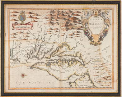
Antique Map of Part of Virginia, c. 1939
Similar Sale History
View More Items in Maps & AtlasesRelated Maps & Atlases
More Items in Maps & Atlases
View MoreRecommended Transportation & Travel Collectibles
View More


Item Details
Description
Description: Antique map on heavy stock paper depicting the Virginia towns of Jamestown, Williamsburg and Yorktown by Robert Ball. Map details feature subtle hand tinting highlighted with red. Circa 1939 from Williamsburg Restoration Inc. The map's purpose was to rise funds for the Williamsburg Restoration Project started by Rockefeller. Only a limited number of prints were issued. Material: paper. Measurement: approximate 17.5"h x 29"w (INCHES). Shipping cost: $15; different rate applies for Alaska, California & Hawaii. International rate applies.
Condition
Good
Buyer's Premium
- 0%
Antique Map of Part of Virginia, c. 1939
Estimate $100 - $300
1 bidder is watching this item.
Shipping & Pickup Options
Item located in Bay Shore, NY, usSee Policy for Shipping
Payment

Related Searches
TOP


![1894 Cowles Civil War Map of Virginia and Parts of West: Title/Content of Map: 1894 Cowles Civil War Map of Virginia and Parts of West Virginia and Maryland -- General Topographical Map, Sheet II [Plate CXXXVII] Cartographer: C Cowles (compiled by) Year/Pla](https://p1.liveauctioneers.com/5584/171770/86526634_1_x.jpg?height=310&quality=70&version=1592950942)


![1894 Cowles Civil War Map of Northern Virginia, Maryland, Delaware and Parts of West Virginia and: Title: 1894 Cowles Civil War Map of Northern Virginia, Maryland, Delaware and Parts of West Virginia and Pennsylvania -- General Topographical Map, Sheet I [Plate CXXXVI] Cartographer: C Cowles (compi](https://p1.liveauctioneers.com/5584/300803/160207035_1_x.jpg?height=310&quality=70&version=1693946338)


![South-west Europe. Swiss Savoy. British Hanover. THOMSON 1817 old antique map: TITLE/CONTENT OF MAP: [South-west sheet of] A map of Europe, with the political divisions after the Peace of Paris and Congress of Vienna The map shows south west Europe after the Congress of Vienna.](https://p1.liveauctioneers.com/5584/328641/177014448_1_x.jpg?height=310&quality=70&version=1715113718)


![[Maps] Gio. Ant. Magnini, Italia, 1620: [Maps] Gio. Ant. Magnini, Italia, 1620, Giovanni Antonio Magnini. Italia, data in luce da Fabio suo figliuolo al Serenissimo Ferdinado Gonzaga Duca di Matoua edi Monserrato etc. Bologna, for Sebastian](https://p1.liveauctioneers.com/188/326797/176317457_1_x.jpg?height=310&quality=70&version=1713847031)
![[Maps] Martin Zeiler, Itinerarium Italiae, 1640: [Maps] Martin Zeiler, Itinerarium Italiae, 1640, Martini Zeilleri. Itinerarium Italiae Nov-Antiquae: oder, Raiss-Beschreibung durch Italien, Matthaus Merian, Frankfurt, 40 plates, most double-page, in](https://p1.liveauctioneers.com/188/326797/176317459_1_x.jpg?height=310&quality=70&version=1713847031)


![[MAP]. TODESCHI, Pietro. [Nova et Acurata Totius Americae Tabula auct. G.I. Blaeu] America quarta: [MAP]. TODESCHI, Pietro. [Nova et Acurata Totius Americae Tabula auct. G.I. Blaeu] America quarta pars orbis quam plerunq, nuvum orbem appellitant primo detecta est anno 1492 a Christophoro Columbo...](https://p1.liveauctioneers.com/197/329395/177650542_1_x.jpg?height=310&quality=70&version=1715364962)


