


 Discovery- InteriorsBonhamsSponsored.Your ad here?
Discovery- Interiors
Bonhams
Sponsored.Your ad here?


Discovery- InteriorsBonhamsSponsored.Your ad here?
Discovery- Interiors
Bonhams
Sponsored.Your ad here?

1855 Colton Map of Minnesota and the Dakotas --
Similar Sale History
View More Items in Maps & Atlases


Related Maps & Atlases


More Items in Maps & Atlases
View More


![[Maps] Martin Zeiler, Itinerarium Italiae, 1640: [Maps] Martin Zeiler, Itinerarium Italiae, 1640, Martini Zeilleri. Itinerarium Italiae Nov-Antiquae: oder, Raiss-Beschreibung durch Italien, Matthaus Merian, Frankfurt, 40 plates, most double-page, in](https://p1.liveauctioneers.com/188/326797/176317459_1_x.jpg?height=310&quality=70&version=1713847031)


![[Maps] Gio. Ant. Magnini, Italia, 1620: [Maps] Gio. Ant. Magnini, Italia, 1620, Giovanni Antonio Magnini. Italia, data in luce da Fabio suo figliuolo al Serenissimo Ferdinado Gonzaga Duca di Matoua edi Monserrato etc. Bologna, for Sebastian](https://p1.liveauctioneers.com/188/326797/176317457_1_x.jpg?height=310&quality=70&version=1713847031)


Recommended Transportation & Travel Collectibles
View More


Item Details
Description
Reserve Reduced!
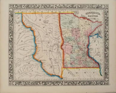
Title/Content of Map: 1855 Colton Map of Minnesota and the Dakotas -- Minnesota Date: 1855, New York Cartographer: J Colton Size: 11.8 X 15.7 in.
This is an excellent map of Minnesota and the emerging Dakotah (Dakota) Territory, well before separating into North and South. The northern Minnesota counties are yet to form and there is no Duluth. Shown is the proposed Pacific Railroad route proposed by Gov. Stevens. Plenty of details are offered as to topography, rivers, lakes, cities and towns, roads, railroads, canals, etc. Color-coded counties. The Colton decorative border is yet to appear. From the first edition, second issue of Colton's General Atlas.
Reserve: $130.00 Jasper52 negotiates the lowest reserves so bidders always get the best prices.
Shipping: Domestic: Flat-rate of $12.00 to anywhere within the contiguous U.S. International: Foreign shipping rates are determined by destination. Combined shipping: Please ask about combined shipping for multiple lots before bidding. Location: This item ships from Ohio
Your purchase is protected:
Photos, descriptions, and estimates were prepared with the utmost care by a fully certified expert and appraiser. All items in this sale are guaranteed authentic.
In the rare event that the item did not conform to the lot description in the sale, Jasper52 specialists are here to help. Buyers may return the item for a full refund provided you notify Jasper52 within 5 days of receiving the item.
This is an excellent map of Minnesota and the emerging Dakotah (Dakota) Territory, well before separating into North and South. The northern Minnesota counties are yet to form and there is no Duluth. Shown is the proposed Pacific Railroad route proposed by Gov. Stevens. Plenty of details are offered as to topography, rivers, lakes, cities and towns, roads, railroads, canals, etc. Color-coded counties. The Colton decorative border is yet to appear. From the first edition, second issue of Colton's General Atlas.
Reserve: $130.00
Shipping:
Your purchase is protected:
Photos, descriptions, and estimates were prepared with the utmost care by a fully certified expert and appraiser. All items in this sale are guaranteed authentic.
In the rare event that the item did not conform to the lot description in the sale, Jasper52 specialists are here to help. Buyers may return the item for a full refund provided you notify Jasper52 within 5 days of receiving the item.
Condition
Very Good - excellent. Slight toning, and marginal soiling. Hand colored.
Buyer's Premium
- 15%
1855 Colton Map of Minnesota and the Dakotas --
Estimate $150 - $200
3 bidders are watching this item.
Shipping & Pickup Options
Item located in Ohio, US$12 shipping in the US
Payment
See More Items From This Jasper52 Seller

Auction Curated By

Maps Expert
Related Searches
TOP