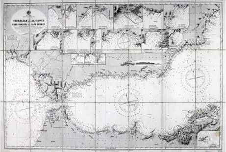
Thomson: Antique Chart Map of Mediterranean Sea, 1817
Similar Sale History
View More Items in Maps & AtlasesRelated Maps & Atlases
More Items in European Maps & Atlases
View MoreRecommended Transportation & Travel Collectibles
View More


Item Details
Description
Chart of the Mediterranean Sea. Bay & roads of Marseilles. The harbour of Genoa. Plan of the Rock and Bay of Gibraltar, shewing the position of the combined fleet and attack of the battering ships in 1782. Gulf of Smyrna. Attack on Algiers by the fleet under the command of Lord Exmouth, August 27th 1816. Sketch of the watering place of Algeziras. Leghorn Road' This large map has seven inset charts of the Mediterranean ports of Marseilles, Genoa, Gibraltar, Leghorn (Livorno), Algeciras, Algiers and the Gulf of Smyrna (Izmir). Each inset chart has depth soundings marked.
Date Printed: 1817 Image Size: Approx 53.0 x 64.0cm, 20.75 x 25.25 inches (Large); Please note that this is a folding map. Type: Antique early 19th century atlas map with original hand colouring Condition: Good; suitable for framing. However, please note: Minor offsetting -text and/or images from the facing page have left an impression on the print. Verso: There is nothing printed on the reverse side, which is plain Folding: This is a folding map. Artist/Cartographer/Engraver: Drawn & engraved by Samuel John Neele for John Thomson's "New General Atlas" Provenance: "A new general atlas, consisting of a series of geographical designs, on various projections, exhibiting the form and component parts of the globe; and a collection of maps and charts, delineating the natural and political divisions of the Empires, Kingdoms, and States in the World", Edinburgh: Printed by George Ramsay and Company, for John Thomson and Company, Edinburgh; Baldwin, Cradock, and Joy, London; and John Cumming, Dublin
John Thomson (1777-1840) was a Scottish cartographer from Edinburgh, best known for his 1817 New General Atlas.
Shipping: Domestic: Flat-rate of $24.00 to anywhere within the contiguous U.S. International: Foreign shipping rates are determined by destination. Location: This item ships from United Kingdom
Your purchase is protected:
Photos, descriptions, and estimates were prepared with the utmost care by a fully certified expert and appraiser. All items in this sale are guaranteed authentic.
In the rare event that your purchase from this auction does not meet your expectations, Jasper52 specialists are here to help. If the item did not conform to the lot description in the sale, U.S. buyers may return the item for a full refund provided you notify Jasper52 within 5 days of receiving the item.
John Thomson (1777-1840) was a Scottish cartographer from Edinburgh, best known for his 1817 New General Atlas.
Shipping:
Your purchase is protected:
Photos, descriptions, and estimates were prepared with the utmost care by a fully certified expert and appraiser. All items in this sale are guaranteed authentic.
In the rare event that your purchase from this auction does not meet your expectations, Jasper52 specialists are here to help. If the item did not conform to the lot description in the sale, U.S. buyers may return the item for a full refund provided you notify Jasper52 within 5 days of receiving the item.
Condition
Good; suitable for framing. However, please note: Minor offsetting -text and/or images from the facing page have left an impression on the print.
Buyer's Premium
- 10%
Thomson: Antique Chart Map of Mediterranean Sea, 1817
Estimate $275 - $325
5 bidders are watching this item.
Shipping & Pickup Options
Item located in United KingdomSee Policy for Shipping
Payment
Accepts seamless payments through LiveAuctioneers
See More Items From This Jasper52 Seller

Auction Curated By

Maps Expert
TOP


![Mount & Page: Antique Coast Profile of Ireland, 1749: Title/Content of Map: '[A description of the sea coast of Ireland]' The following places are shown or referred to on the coastal profile chart: Galloway (Galway) Aran Islands Limerick Date Printed: 17](https://p1.liveauctioneers.com/5584/110608/56777156_1_x.jpg?height=310&quality=70&version=1507840413)


