Revolutionary War Map
Similar Sale History
View More Items in Militaria & War Memorabilia
Related Militaria & War Memorabilia
More Items in American Revolutionary Period Militaria & War Memorabilia
View MoreRecommended Collectibles
View More


Item Details
Description
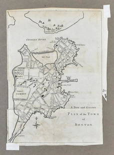
Map, 18” x 11,” “Plan of the Siege of Charleston in S. Carolina" 1807, publishedC.P. Wayne, Philadelphia, withdrawn from book. Showing the location of downtown Charleston, Fort Sullivan (later named Fort Moultrie),Sullivans Island, James Island, Fort Johnson, Ashley River, Cooper River and Stono River in 1780. The Siege of Charleston was a major engagement fought between March 29 to May 12, 1780 during the American Revolutionary War. The British, following the collapse of their northern strategy and their withdrawal from Philadelphia, shifted their focus to the American Southern Colonies.
Buyer's Premium
- 23%
Revolutionary War Map
Estimate $300 - $500
9 bidders are watching this item.
Shipping & Pickup Options
Item located in Burlington, NC, usSee Policy for Shipping
Payment

TOP


![1777 1st American Rev War Battle Map: SEAT of WAR: American Revolution First American Printing Of A Revolutionary War Battle Map "A View of the Present Seat of War, at and near New-York." [1776] Revolutionary War Printed, First American printed Revolu](https://p1.liveauctioneers.com/218/230033/119008047_1_x.jpg?height=310&quality=70&version=1639440290)


![[Daguerreotype] Revolutionary War & War of 1812 Hero: Quarter plate daguerreotype. Thermoplastic case affixed with a silver plaque engraved "Genl. Mooers, Plattsburgh, NY." c. 1855 daguerreotype of an early painted portrait of General Benjamin Mooers (17](https://p1.liveauctioneers.com/7226/322253/173251484_1_x.jpg?height=310&quality=70&version=1710004847)


![[REVOLUTIONARY WAR] 1783 Treasury Receipt re: Robert Morris: Autograph document signed by John Lawrence. Hartford, Connecticut, 31 March 1783. 1 page, 8 1/4 x 7 5/8 in. Docketed and signed by Captain Jabez Perkins to verso. A scarce treasury receipt document fr](https://p1.liveauctioneers.com/7226/322253/173251483_1_x.jpg?height=310&quality=70&version=1710004847)


![George Washington Signed Discharge: Partly printed discharge document signed by George Washington, as Commander in Chief of the Armies of the United States. Newburgh, [New York], 4 January 1783. 1 page, ## x ## in. Undersigned by Washin](https://p1.liveauctioneers.com/7226/322253/173251475_1_x.jpg?height=310&quality=70&version=1710004847)


![[Ambrotype] Texas Confederate Soldier: Sixth plate ambrotype. Full leatherette case. Portrait of a possible Texas Confederate soldier. A silver star device was used to pin up the brim of his light-toned headgear, a look often seen in image](https://p1.liveauctioneers.com/7226/322253/173251509_1_x.jpg?height=310&quality=70&version=1710004847)


