1760 French + Indian War Map Louisiana + Florida
Similar Sale History

Recommended Items


Item Details
Description
Historic Maps
French & Indian War Era Map of Louisiana & Florida
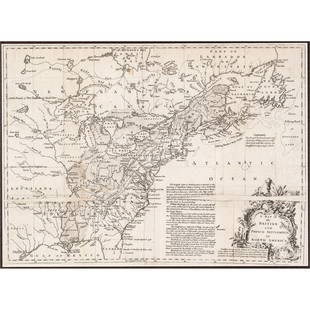
c. 1760 French & Indian War Era, Historic Map Titled, “Carte de la Louisiane, et de la Floride. Par M. Bonne, Ingenieur-Hydrographe de la Marine,” France, Choice Very Fine.
This historical Map by Bonne beautifully details the land areas of Louisiana and Florida in the early Colonial days of the United States, well before these areas became part of the Union. It measures 10.5 x 15.5” on sharply printed on clean, fine quality period laid paper. . It retains wide original deckled margins, slightly within some light edge tone where this piece was previously framed. Light pencil notation is in the lower left with a 1760 date. Rigobert Bonne (1727–1795) was one of the most important cartographers of the late 18th century. Bonne compiled some of the most detailed and accurate maps of the period. This well detailed Map highlights New Orleans and depicts the Louisiana area extending as far north as Illinois. Overall, in lovely condition, being ready for framing and display.
Rigobert Bonne (1727–1795) was one of the most important cartographers of the late 18th century.
In 1773 Bonne succeeded Jacques Nicolas Bellin as Royal Cartographer to France in the office of the Hydrographer at the Depôt de la Marine. Working in his official capacity, Bonne compiled some of the most detailed and accurate maps of the period. Bonne’s work represents an important step in the evolution of the cartographic ideology away from the decorative work of the 17th and early 18th century towards a more detail oriented and practical aesthetic.
With regard to the rendering of terrain Bonne maps bear many stylistic similarities to those of his predecessor, Bellin. However, Bonne maps generally abandon such common 18th century decorative features such as hand coloring, elaborate decorative cartouches, and compass roses.
While mostly focusing on coastal regions, the work of Bonne is highly regarded for its detail, historical importance, and overall aesthetic appeal.
Buyer's Premium
- 23%
1760 French + Indian War Map Louisiana + Florida
Estimate $800 - $1,000
5 bidders are watching this item.
Shipping & Pickup Options
Item located in Rancho Santa Fe, CA, usSee Policy for Shipping
Payment

Related Searches
TOP


![[MAP]. SARTINE, Antoine Plan de la Barre et du Havre de Charles-Town...1778. RARE REVOLUTIONARY WAR: [MAP]. SARTINE, Antoine (1729-1801). Plan de la Barre et du Havre de Charles-Town d'apres un plan Anglois leve en 1776... Paris: Depot de la Marine for M. de Sartine, 1778. Copperplate engraving, matt](https://p1.liveauctioneers.com/197/329395/177650540_1_x.jpg?height=310&quality=70&version=1715364962)


