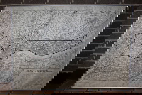
Samuel Parker. MAP OF OREGON TERRITORY. 1838.
Similar Sale History
View More Items in Maps & Atlases

Related Maps & Atlases
More Items in Maps & Atlases
View MoreRecommended Transportation & Travel Collectibles
View More


Item Details
Description
[West] MAP OF OREGON TERRITORY. By Samuel Parker. 1838. Margin at lower right: “Engd. By M. M. Peabody, Utica, N. Y.” From “Journal of an Exploring Tour Beyond the Rocky Mountains, under the Direction of A. B. C. F. M. Containing a Descritpion of the Geography, Geology, Climate, Productions of the Country…,” [Ithaca: Andrus, Woodruff, and Guantlett.] Wheat, TM, 438. Howes P89. “…map is the first of the Oregon interior done with any accuracy.” -Streeter Sale 2093. Substantial attention to rivers and other physcial features, including the Columbia watershed, with most of the Missouri and Platte basins and Salt Lake. Labels Native American tribes. The area covered extends from the Pacific well into the Great Plains (to Lesser Slave Lake, Lake Winnipeg, the Omahas, and the Grand Pawnees in modern-day Missouri). 13 ¾ x 23 ¼ in. Slight foxing, sight condition very good. Matted, under glass. Not examined out of frame.
Buyer's Premium
- 22%
Samuel Parker. MAP OF OREGON TERRITORY. 1838.
Estimate $200 - $300
5 bidders are watching this item.
Shipping & Pickup Options
Item located in Falls Church, VA, usSee Policy for Shipping
Payment

Related Searches
TOP


![Pictorial map of Oregon Territory: Heading: (Oregon) Author: Ries, E. Karolyn Title: A map of the Oregon Country showing the Original Territory Place Published: No place Publisher: Date Published: No date [c.1930s] Descr](https://p1.liveauctioneers.com/642/310901/166355373_1_x.jpg?height=310&quality=70&version=1701367957)


![A Map Of The County Of Kent. Samuel Parker, 1719.: [British Counties] A Map Of The County Of Kent. Samuel Parker, 1719. Folding map on 2 adjoined folding sheets, giving an impressively detailed depiction of rivers and towns in the county at the southe](https://p1.liveauctioneers.com/179/117971/60557711_1_x.jpg?height=310&quality=70&version=1520636872)


![Large Map of Alaska: Large Map of Alaska With map of Washington and Oregon [separately] on versos Cartographer: George Franklin Cram Dated: Circa 1900 Type: Color Lithograph Dimensions: 14](https://p1.liveauctioneers.com/5614/330257/178045317_1_x.jpg?height=310&quality=70&version=1716032806)


![[MAP]. TODESCHI, Pietro. [Nova et Acurata Totius Americae Tabula auct. G.I. Blaeu] America quarta: [MAP]. TODESCHI, Pietro. [Nova et Acurata Totius Americae Tabula auct. G.I. Blaeu] America quarta pars orbis quam plerunq, nuvum orbem appellitant primo detecta est anno 1492 a Christophoro Columbo...](https://p1.liveauctioneers.com/197/329395/177650542_1_x.jpg?height=310&quality=70&version=1715364962)


![[MAPS]. HOMANN, Johann Baptist, HOMANN HEIRS, and Georg Matthäus SEUTTER. [Composite Atlas].: [MAPS]. HOMANN, Johann Baptist (1663-1724), HOMANN HEIRS, and Georg Matthäus SEUTTER (1678-1757). [Composite Atlas]. [Nuremberg, Augsburg, and others: Homann Heirs and others, maps dated between](https://p1.liveauctioneers.com/197/329395/177650530_1_x.jpg?height=310&quality=70&version=1715364962)


![[MAP]. ORTELIUS, Abraham. Turcici Imperii Descriptio.1592.: [MAP]. ORTELIUS, Abraham (1527-1598). Turcici Imperii Descriptio. Antwerp, 1592. Engraved map with hand-coloring. Matted, framed, and double glazed, sight 406 x 521 mm (unexamined out of frame). Decor](https://p1.liveauctioneers.com/197/329395/177650538_1_x.jpg?height=310&quality=70&version=1715364962)
![[MAP]. ORTELIUS, Abraham. Americae Sive Novi Orbis, Nova Descriptio. 1573.: [MAP]. ORTELIUS, Abraham (1527-1598). Americae Sive Novi Orbis, Nova Descriptio. Antwerp, 1573. Engraved map with hand-coloring. Framed and double glazed, visible area 375 x 521 mm (unexamined out of](https://p1.liveauctioneers.com/197/329395/177650534_1_x.jpg?height=310&quality=70&version=1715364962)


![[FLAGS]. 31-star American parade flag. Ca 1850-1859.: [FLAGS]. 31-star American parade flag. Ca 1850-1859. 22 x 36 1/2 in. cotton flag with 31 printed stars, configured in a double medallion surrounding a much larger central star, that is haloed in both](https://p1.liveauctioneers.com/197/329785/177758218_1_x.jpg?height=310&quality=70&version=1715625218)


