


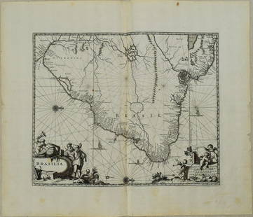
1650 Blaeu Map of Brazil -- Brasilia
Similar Sale History
View More Items in Maps & Atlases

![Churchill & Nieuhof 1744 Folio Map. Brasilia Brazil: Folio Copper Engraved Map Published 1704-47 [1744] London for "A Collection of Voyages and Travels..." By Awnsham & John Churchill. The work based mostly on the Voyages and Travels into Brasil and the](https://p1.liveauctioneers.com/3952/320085/171971821_1_x.jpg?height=310&quality=70&version=1708266709)


Related Maps & Atlases


![[MAP]. TODESCHI, Pietro. [Nova et Acurata Totius Americae Tabula auct. G.I. Blaeu] America quarta: [MAP]. TODESCHI, Pietro. [Nova et Acurata Totius Americae Tabula auct. G.I. Blaeu] America quarta pars orbis quam plerunq, nuvum orbem appellitant primo detecta est anno 1492 a Christophoro Columbo...](https://p1.liveauctioneers.com/197/329395/177650542_1_x.jpg?height=310&quality=70&version=1715364962)


![[NEW YORK CITY – PICTORIAL MAPS]. Group of 3 pictorial maps...: [NEW YORK CITY – PICTORIAL MAPS]. Group of 3 pictorial maps. Including: ANNAND, George (1890—1980). Sinclair Pictorial Map of New York/New York World’s Fair. 26 ¾ x 27 5/8”](https://p1.liveauctioneers.com/928/325952/175495562_1_x.jpg?height=310&quality=70&version=1712935174)
More Items in Maps & Atlases
View More![[Maps] Gio. Ant. Magnini, Italia, 1620: [Maps] Gio. Ant. Magnini, Italia, 1620, Giovanni Antonio Magnini. Italia, data in luce da Fabio suo figliuolo al Serenissimo Ferdinado Gonzaga Duca di Matoua edi Monserrato etc. Bologna, for Sebastian](https://p1.liveauctioneers.com/188/326797/176317457_1_x.jpg?height=310&quality=70&version=1713847031)
![[Maps] Martin Zeiler, Itinerarium Italiae, 1640: [Maps] Martin Zeiler, Itinerarium Italiae, 1640, Martini Zeilleri. Itinerarium Italiae Nov-Antiquae: oder, Raiss-Beschreibung durch Italien, Matthaus Merian, Frankfurt, 40 plates, most double-page, in](https://p1.liveauctioneers.com/188/326797/176317459_1_x.jpg?height=310&quality=70&version=1713847031)


Recommended Transportation & Travel Collectibles
View More


Item Details
Description
This is a magnificent large map of most of Brazil, Guiana and Uruguay. The map extends north of the Amazon to Rio de la Plata in the south. It is Blaeu's second map of this area with detail confined to the coastlines and the map oriented with north to the right of the map. The coastline is very detailed, while inland the cartography is highly conjectural and mostly empty, and contains mythical features such as Parime Lago in Guiana. The map reflects the short-lived Dutch influence in Brazil through the Dutch West-India Company. It is richly embellished with a title cartouche featuring the Dutch coat of arms, a distance scale cartouche with three putti, compass roses, galleons, and rhumb lines. The map is dedicated to Christoph Arciszewski, who was a Polish nobleman and officer in the service of the West India Company. Latin text on verso.
Reserve: 350
Shipping:
Your purchase is protected:
Photos, descriptions, and estimates were prepared with the utmost care by a fully certified expert and appraiser. All items in this sale are guaranteed authentic.
In the rare event that the item did not conform to the lot description in the sale, Jasper52 specialists are here to help. Buyers may return the item for a full refund provided you notify Jasper52 within 5 days of receiving the item.
Condition
Good. On laid paper. Slight soiling and small marginal chips and splits. Issued centerfold. Uncolored.
Buyer's Premium
- 15%
1650 Blaeu Map of Brazil -- Brasilia
Estimate $400 - $500
1 bidder is watching this item.
Shipping & Pickup Options
Item located in Ohio, US$19 shipping in the US
Payment
Accepts seamless payments through LiveAuctioneers
See More Items From This Jasper52 Seller

TOP