Calif. Terr. of N. Mex. & Utah, 1862 - Johnson
Similar Sale History
View More Items in Maps & AtlasesRelated Maps & Atlases
More Items in Maps & Atlases
View MoreRecommended Transportation & Travel Collectibles
View More


Item Details
Description
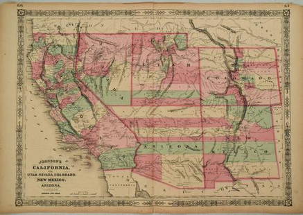
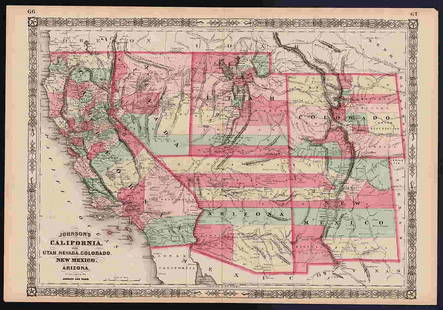
One of the scarcest and most historically significant of A. J. Johnson’s southwest series, and one of the few maps issued during the very short and politically volatile period to specifically depict the Confederate Territory of “Arrizona.” Published by Johnson & Ward in 1862 at the height of the American Civil War, this stunning map depicts the state of California and the territories of Nevada, Utah, Colorado, New Mexico and Arizona. Representing the third state of the Johnson southwest map, this map varies most significantly from its 1861 predecessor in the addition of a clearly defined Arizona. Varies from the previous state of the map in that the California – Nevada border has been corrected to a straight line between Pyramid Peak (where several Mormon settlements are noted) and Fort Moliare. Elsewhere, Utah and Arizona are split vertically along the 116th meridian, far west of where it sits today. Fillmore City is shown as the capital of Utah. In Colorado the Gold Region near Colorado City is prominently depicted. Throughout, this map is full of interesting and sometimes erroneous notations regarding natural features, Native American tribes, proposed railroads, mail routes, explorer’s tracks, and treaty lines. In the desert region near modern day Quartzite, Arizona, a note reads “in the vicinity of this place a tract of country is found which is said by Trappers to be exceedingly and fertile and abundantly timbered and well watered.” Silver deposits are noted near this same region. “Vegas” appears roughly in its modern location, though at the time it was little more than a natural water source and an abandoned Mormon fort. The famed Pony Express Route is delineated as it passes through Nebraska, Utah, and Nevada on its way to California. An extraordinarily example of one of the scarcest and most desirable maps of the American Southwest. Beautifully centered and a clear and solid plate impression. Excellent original hand coloring. Few very light and insignificant marks in image and margin. Extremely light and minor toning to narrow area of centerfold. Very tiny bit of offsetting at lower right. Two very tiny repaired edge tears. Paper in excellent condition (Johnson maps are often found to be somewhat brittle). 16.75 x 24.
Reserve: $375.00
Shipping:Domestic: Flat-rate of $8.00 to anywhere within the contiguous U.S. International: Foreign shipping rates are determined by destination. Combined Shipping: Please ask about combined shipping for multiple lots before bidding. Location: This item ships from Ohio.
Your purchase is protected:
Photos, descriptions, and estimates were prepared with the utmost care by a fully certified expert and appraiser. All items in this sale are guaranteed authentic.
In the rare event that the item did not conform to the lot description in the sale, Jasper52 specialists are here to help. Buyers may return the item for a full refund provided when you notify Jasper52 within 5 days of receiving the item.
Reserve: $375.00
Shipping:
Your purchase is protected:
Photos, descriptions, and estimates were prepared with the utmost care by a fully certified expert and appraiser. All items in this sale are guaranteed authentic.
In the rare event that the item did not conform to the lot description in the sale, Jasper52 specialists are here to help. Buyers may return the item for a full refund provided when you notify Jasper52 within 5 days of receiving the item.
Condition
Very good plus
Buyer's Premium
- 15%
Calif. Terr. of N. Mex. & Utah, 1862 - Johnson
Estimate $425 - $525
3 bidders are watching this item.
Get approved to bid.
Shipping & Pickup Options
Item located in Ohio, US$8 shipping in the US
Payment
Accepts seamless payments through LiveAuctioneers
See More Items From This Jasper52 Seller

TOP


![1898 Cram Map of Victoria [verso] South Australia and Northern Terr. [verso] Queensland -- Map of: Title: 1898 Cram Map of Victoria [verso] South Australia and Northern Terr. [verso] Queensland -- Map of Victoria [verso] South Australia [verso] Queensland Cartographer: G Cram Year / Place: 1898 c.](https://p1.liveauctioneers.com/5584/331064/178466379_1_x.jpg?height=310&quality=70&version=1716924723)


![Trinity County Mines (Wall) Map, 1894, Cowden, Johnson [177508]: Large wall map, 3 x 5 feet, varnish, cloth backed, excellent condition. Incredible, and rare map, shaded relief, shows 160 of the most important mines and mine owners, plus owners of all private parce](https://p1.liveauctioneers.com/2699/331495/178785752_1_x.jpg?height=310&quality=70&version=1717094933)

![[MAPS]. HOMANN, Johann Baptist, HOMANN HEIRS, and Georg Matthäus SEUTTER. [Composite Atlas].: [MAPS]. HOMANN, Johann Baptist (1663-1724), HOMANN HEIRS, and Georg Matthäus SEUTTER (1678-1757). [Composite Atlas]. [Nuremberg, Augsburg, and others: Homann Heirs and others, maps dated between](https://p1.liveauctioneers.com/197/329395/177650530_1_x.jpg?height=310&quality=70&version=1715364962)
![[MAP]. TODESCHI, Pietro. [Nova et Acurata Totius Americae Tabula auct. G.I. Blaeu] America quarta: [MAP]. TODESCHI, Pietro. [Nova et Acurata Totius Americae Tabula auct. G.I. Blaeu] America quarta pars orbis quam plerunq, nuvum orbem appellitant primo detecta est anno 1492 a Christophoro Columbo...](https://p1.liveauctioneers.com/197/329395/177650542_1_x.jpg?height=310&quality=70&version=1715364962)

![[MAP]. ORTELIUS, Abraham. Americae Sive Novi Orbis, Nova Descriptio. 1573.: [MAP]. ORTELIUS, Abraham (1527-1598). Americae Sive Novi Orbis, Nova Descriptio. Antwerp, 1573. Engraved map with hand-coloring. Framed and double glazed, visible area 375 x 521 mm (unexamined out of](https://p1.liveauctioneers.com/197/329395/177650534_1_x.jpg?height=310&quality=70&version=1715364962)


![Set of Twelve Satirical Anthropomorphic Maps of Europe: [SATIRICAL MAPS] A set of twelve satirical anthropomorphic maps of Europe. London: circa 1868. A set of 12 (believed complete) lithographed maps by Vincent Brooks, Day & Son, London, each offering](https://p1.liveauctioneers.com/292/330597/178279264_1_x.jpg?height=310&quality=70&version=1716409282)


![[MAP]. ORTELIUS, Abraham. Turcici Imperii Descriptio.1592.: [MAP]. ORTELIUS, Abraham (1527-1598). Turcici Imperii Descriptio. Antwerp, 1592. Engraved map with hand-coloring. Matted, framed, and double glazed, sight 406 x 521 mm (unexamined out of frame). Decor](https://p1.liveauctioneers.com/197/329395/177650538_1_x.jpg?height=310&quality=70&version=1715364962)
![[MAP]. ORTELIUS, Abraham. Romani Imperii Imago. 1592.: [MAP]. ORTELIUS, Abraham (1527-1598). Romani Imperii Imago. Antwerp, 1592. Engraved map with hand-coloring. Matted, framed, and double glazed, visible area 381 x 521 mm (unexamined out of frame). 6 de](https://p1.liveauctioneers.com/197/329395/177650537_1_x.jpg?height=310&quality=70&version=1715364962)
![[MAP]. SPEED, John. A New Mappe of the Romane Empire. 1676.: [MAP]. SPEED, John (ca 1551-1629). A New Mappe of the Romane Empire. London: Basset & Chiswell, 1676. Engraved map with hand-coloring. Framed and double glazed, sight 419 x 559 mm. Decorative cartouch](https://p1.liveauctioneers.com/197/329395/177650541_1_x.jpg?height=310&quality=70&version=1715364962)
![[MAP]. ORTELIUS, Abraham. Aevi Veteris, Typus Geographicus. 1601.: [MAP]. ORTELIUS, Abraham (1527-1598). Aevi Veteris, Typus Geographicus. Antwerp, 1601. Engraved map with hand-coloring. Matted, framed, and double glazed, visible area 343 x 470 mm (unexamined out of](https://p1.liveauctioneers.com/197/329395/177650532_1_x.jpg?height=310&quality=70&version=1715364962)


