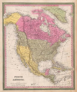
N. America, Johnson & Browning 1861
Similar Sale History
View More Items in Maps & AtlasesRelated Maps & Atlases
More Items in Maps & Atlases
View MoreRecommended Transportation & Travel Collectibles
View More


Item Details
Description
Impressive early Johnson map of North America with huge top and bottom margins. This map’s most significant change over earlier Johnson & Browning versions is the inclusion of Colorado territory, which was incorporated in February of 1861, just as the map was about to be published. Nevada also became a territory in 1861. The outbreak of the Civil War and the wealth of silver under Virginia City (here identified as ‘Mormon Settlement’) speeded up Nevada attaining territorial status. The new borders of Nevada as set in the territorial charter forced Johnson to revise his 1860 map, moving the Utah-Nevada border three degrees west to longitude 116 and the California border westward to the Sierra Nevada range. This unusual choice infringed upon California’s border charter inciting a border dispute between the two regions. The dispute was formally resolved in 1863 roughly according to the original California charter. Besides Johnson's California Territories of New Mexico and Utah, this is the only other example of Johnson’s southwest map to show Nevada’s original territorial border configuration. The odd Nevada borderline is clearly shown running down the top edge of “Sierra Mountains” but the colorist apparently wasn’t advised of the change in border. In New Mexico and Arizona Johnson has removed the latitudinal border between New Mexico and Arizona that he included in the 1860 edition of his atlas. This was most likely in response to Arizona’s petition for territorial status independent of New Mexico being denied by the U.S. Congress. With only a small population and minimal political influence this region was largely ignored by the New Mexico territorial government in distant Santa Fe. Though Arizona applied several times to be granted independent territorial status, its low population caused the request to be repeatedly rejected. Curiously, in the same year this map as issued, the Confederate Col. John Robert Baylor would invade southern New Mexico and declare himself governor of the Confederate State of Arizona, which briefly reappears in the 1862 and 1863 Civil War editions of this map. 16.5 x 22.
Reserve: $140.00
Shipping:Domestic: Flat-rate of $8.00 to anywhere within the contiguous U.S. International: Foreign shipping rates are determined by destination. International shipping may be subject to VAT. Combined shipping: Please ask about combined shipping for multiple lots before bidding. Location: This item ships from Ohio
Your purchase is protected:
Photos, descriptions, and estimates were prepared with the utmost care by a fully certified expert and appraiser. All items in this sale are guaranteed authentic.
In the rare event that the item did not conform to the lot description in the sale, Jasper52 specialists are here to help. Buyers may return the item for a full refund provided you notify Jasper52 within 5 days of receiving the item.
Reserve: $140.00
Shipping:
Your purchase is protected:
Photos, descriptions, and estimates were prepared with the utmost care by a fully certified expert and appraiser. All items in this sale are guaranteed authentic.
In the rare event that the item did not conform to the lot description in the sale, Jasper52 specialists are here to help. Buyers may return the item for a full refund provided you notify Jasper52 within 5 days of receiving the item.
Condition
Very good
Buyer's Premium
- 15%
N. America, Johnson & Browning 1861
Estimate $175 - $250
2 bidders are watching this item.
Shipping & Pickup Options
Item located in Ohio, US$8 shipping in the US
Payment
Accepts seamless payments through LiveAuctioneers
See More Items From This Jasper52 Seller

TOP


![[MAPS]. Map of the Pacific Rail Road and its Connections with the Seaports of the United States of: [MAPS]. Map of the Pacific Rail Road and its Connections with the Seaports of the United States of America. New York: Johnson & Browning, 1860. Lithographed map of the United States, hand-colore](https://p1.liveauctioneers.com/197/265300/138516599_1_x.jpg?height=310&quality=70&version=1666052782)


![Travels In N. America In1827-28, hand colored map, 1830: Title: Travels In North America, In The Years 1827 And 1828 Provenance: IN THREE VOLUMES, 1830, with large hand colored folding map of United States and Canada showing Capt. Hall's route. [HOWES H 47]](https://p1.liveauctioneers.com/5584/144949/73283335_1_x.jpg?height=310&quality=70&version=1561753751)


![[Maps] Martin Zeiler, Itinerarium Italiae, 1640: [Maps] Martin Zeiler, Itinerarium Italiae, 1640, Martini Zeilleri. Itinerarium Italiae Nov-Antiquae: oder, Raiss-Beschreibung durch Italien, Matthaus Merian, Frankfurt, 40 plates, most double-page, in](https://p1.liveauctioneers.com/188/326797/176317459_1_x.jpg?height=310&quality=70&version=1713847031)
![[Maps] Gio. Ant. Magnini, Italia, 1620: [Maps] Gio. Ant. Magnini, Italia, 1620, Giovanni Antonio Magnini. Italia, data in luce da Fabio suo figliuolo al Serenissimo Ferdinado Gonzaga Duca di Matoua edi Monserrato etc. Bologna, for Sebastian](https://p1.liveauctioneers.com/188/326797/176317457_1_x.jpg?height=310&quality=70&version=1713847031)


![[MAP]. TODESCHI, Pietro. [Nova et Acurata Totius Americae Tabula auct. G.I. Blaeu] America quarta: [MAP]. TODESCHI, Pietro. [Nova et Acurata Totius Americae Tabula auct. G.I. Blaeu] America quarta pars orbis quam plerunq, nuvum orbem appellitant primo detecta est anno 1492 a Christophoro Columbo...](https://p1.liveauctioneers.com/197/329395/177650542_1_x.jpg?height=310&quality=70&version=1715364962)


