


Government map of Indian Territories
Similar Sale History
View More Items in Maps & Atlases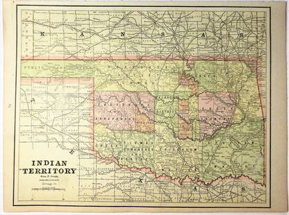


Related Maps & Atlases


![Parker's map of Oregon 1838: Heading: Author: Title: Parker, Samuel Place Published: Map of Oregon Territory Publisher:[Ithaca, NY] Date Published: Description: 1838Copper-engraved folding map. 34.7x58.8 cm](https://p1.liveauctioneers.com/642/326037/175553831_1_x.jpg?height=310&quality=70&version=1713477451)
![Memoir to accompany Missip.-Pacific Map: Heading: Author: Warren, Gouverneur K. Title: Memoir to Accompany the Map of the Territory of the United States from the Mississippi River to the Pacific Ocean Place Published: [Washington, D.C.] Pub](https://p1.liveauctioneers.com/642/326037/175553704_1_x.jpg?height=310&quality=70&version=1713477451)


More Items in Maps & Atlases
View More


Recommended Transportation & Travel Collectibles
View More


Item Details
Description
Heading: (Indian Territory)
Author: Dinsmore, A. F., Lowe, R.P., Naylor, William, Cartographers
Title: Indian Territory. Department of The Interior General Land Office. Hon. Thomas H. Carter, Commissioner. 1891. Compiled from the official Records of the General Land Office and other sources
Place Published: New York
Publisher:Julius Bien & Co.
Date Published: 1891
Description:
28¼x26" separately printed map (not issued in a government report).
Shows the boundaries of the Cherokee, Creek, Seminoles, Chickasaw and Choctaw Nations in Oklahoma with the Arkansas River and the Canadian River shown in blue and the routes of the Missouri Kansas & Texas Railroad, Kansas & Arkansas Valley Railroad and Choctaw Coal & Railway Co.
Condition
Folded; tears at folds and edges, toned; very good.
Buyer's Premium
- 25%
Government map of Indian Territories
Estimate $300 - $500
6 bidders are watching this item.
Shipping & Pickup Options
Item located in Berkeley, CA, usOffers In-House Shipping
Local Pickup Available
Payment

Related Searches
TOP