


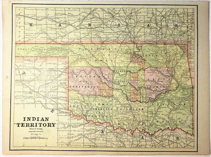
1887 Mitchell Map od Indian Territory -- Indian
Similar Sale History
View More Items in Maps & Atlases![1869 Mitchell Map of Plains States and Colorado --: Title/Content of Map: 1869 Mitchell Map of Plains States and Colorado -- XVIII Kansas, Colorado, New Mexico and Indian Territory [verso] XVI Minnesota and Dakota [also] XVII Nebraska Cartographer: S M](https://p1.liveauctioneers.com/5584/179983/90569362_1_x.jpg?height=310&quality=70&version=1601417445)


Related Maps & Atlases


![1898 Rand McNally Map of Texas [verso] Indian Territory and Oklahoma -- Texas [verso] Oklahoma and: Title: 1898 Rand McNally Map of Texas [verso] Indian Territory and Oklahoma -- Texas [verso] Oklahoma and Indian Territory Cartographer: Rand McNally Year / Place: 1898, Chicago Map Dimension (in.): 9](https://p1.liveauctioneers.com/5584/329422/177662173_1_x.jpg?height=310&quality=70&version=1715717898)


![1878 Mitchell Map of Washington, Oregon, Idaho, much of Montana [verso] Territory of Idaho: Title: 1878 Mitchell Map of Washington, Oregon, Idaho, much of Montana [verso] Territory of Idaho Cartographer: S Mitchell Year / Place: 1878, Philadelphia Map Dimension (in.): 10.8 X 13.4 in. This is](https://p1.liveauctioneers.com/5584/329422/177662232_1_x.jpg?height=310&quality=70&version=1715717898)


More Items in Maps & Atlases
View More![[Maps] Martin Zeiler, Itinerarium Italiae, 1640: [Maps] Martin Zeiler, Itinerarium Italiae, 1640, Martini Zeilleri. Itinerarium Italiae Nov-Antiquae: oder, Raiss-Beschreibung durch Italien, Matthaus Merian, Frankfurt, 40 plates, most double-page, in](https://p1.liveauctioneers.com/188/326797/176317459_1_x.jpg?height=310&quality=70&version=1713847031)

![[Maps] Gio. Ant. Magnini, Italia, 1620: [Maps] Gio. Ant. Magnini, Italia, 1620, Giovanni Antonio Magnini. Italia, data in luce da Fabio suo figliuolo al Serenissimo Ferdinado Gonzaga Duca di Matoua edi Monserrato etc. Bologna, for Sebastian](https://p1.liveauctioneers.com/188/326797/176317457_1_x.jpg?height=310&quality=70&version=1713847031)


![[MAP]. TODESCHI, Pietro. [Nova et Acurata Totius Americae Tabula auct. G.I. Blaeu] America quarta: [MAP]. TODESCHI, Pietro. [Nova et Acurata Totius Americae Tabula auct. G.I. Blaeu] America quarta pars orbis quam plerunq, nuvum orbem appellitant primo detecta est anno 1492 a Christophoro Columbo...](https://p1.liveauctioneers.com/197/329395/177650542_1_x.jpg?height=310&quality=70&version=1715364962)


Recommended Transportation & Travel Collectibles
View More


Item Details
Description
A very nice map of the Indian Territories, but one that does not include the Public Lands of the panhandle. Filled with details of watershed, towns and villages, railroads, forts, military reservations, etc. Delineates the land holdings of the Indian Tribes along with treaty instrument and date. A map of Colorado is on verso. This map is without the often seen Mitchell decorative border. Published by W. Bradley & Bros.
Please note that this lot has a confidential reserve. When you leave a bid in advance of the auction, submit your maximum. The bidder who has submitted the highest bid wins the lot, provided the bid exceeds the reserve price.
Shipping:
Your purchase is protected:
Photos, descriptions, and estimates were prepared with the utmost care by a fully certified expert and appraiser. All items in this sale are guaranteed authentic.
In the rare event that the item did not conform to the lot description in the sale, Jasper52 specialists are here to help. Buyers may return the item for a full refund provided you notify Jasper52 within 5 days of receiving the item.
Condition
Very Good. Slight toning. Crisp coloring.
Buyer's Premium
- 15%
1887 Mitchell Map od Indian Territory -- Indian
Estimate $110 - $150
3 bidders are watching this item.
Shipping & Pickup Options
Item located in Ohio, US$12 shipping in the US
Payment
Accepts seamless payments through LiveAuctioneers
See More Items From This Jasper52 Seller

Auction Curated By

Maps Expert
Related Searches
TOP