


BONNE - American Revolutionary War Map, Paris 1779
Similar Sale History
View More Items in Maps & Atlases


![Manuscript Map of Givet, France on the Belgian Border: [Givet, France]. "Charlemont les deux Givets et la Couronne d'Haurs Pour servir au Projet de mil Sept cent trente sept" Fine manuscript plan in ink and colours on paper (no visible watermark), scale a](https://p1.liveauctioneers.com/1968/273926/143704769_1_x.jpg?height=310&quality=70&version=1672435208)

![Sanson World Atlas, 1659: SANSON D'ABBEVILLE, Nicholas (1600-1667). Cartes Generales de Toutes les Parties du Monde. Paris: The Author and Pierre Mariette, 1658 [but 1659]. Comparables: Arader Galleries, 2015 - $97,600; Christ](https://p1.liveauctioneers.com/1968/250616/130196469_1_x.jpg?height=310&quality=70&version=1654190895)

Related Maps & Atlases
![[MAP]. SARTINE, Antoine Plan de la Barre et du Havre de Charles-Town...1778. RARE REVOLUTIONARY WAR: [MAP]. SARTINE, Antoine (1729-1801). Plan de la Barre et du Havre de Charles-Town d'apres un plan Anglois leve en 1776... Paris: Depot de la Marine for M. de Sartine, 1778. Copperplate engraving, matt](https://p1.liveauctioneers.com/197/329395/177650540_1_x.jpg?height=310&quality=70&version=1715364962)

![Large Map of Alaska: Large Map of Alaska With map of Washington and Oregon [separately] on versos Cartographer: George Franklin Cram Dated: Circa 1900 Type: Color Lithograph Dimensions: 14](https://p1.liveauctioneers.com/5614/330257/178045317_1_x.jpg?height=310&quality=70&version=1716032806)

![Large Map of Texas (Western Part): Large Map of Texas (Western Part) With map of Louisiana and Arkansas [separately] on versos Cartographer: George Franklin Cram Dated: Circa 1900 Type: Color Lithograph Dime](https://p1.liveauctioneers.com/5614/330257/178045313_1_x.jpg?height=310&quality=70&version=1716032806)
![Large Map of Hawaiian Islands & Porto Rico: Large Map of Porto Rico With map of Hawaii - Hawaiian Islands and Samoa [separately] on versos] Cartographer: George Franklin Cram Dated: Circa 1900 Type: Color Lithograph](https://p1.liveauctioneers.com/5614/330257/178045318_1_x.jpg?height=310&quality=70&version=1716032806)
![Large Map of Montana: Large Map of Montana With map of Utah and Wyoming [separately] on versos Cartographer: George Franklin Cram Dated: Circa 1900 Type: Color Lithograph Dimensions: 14 1/2](https://p1.liveauctioneers.com/5614/330257/178045315_1_x.jpg?height=310&quality=70&version=1716032806)
![Large Map of California: Large Map of California With map of Arizona and Nevada [separately] on versos Cartographer: George Franklin Cram Dated: Circa 1900 Type: Color Lithograph Dimensions: 14](https://p1.liveauctioneers.com/5614/330257/178045314_1_x.jpg?height=310&quality=70&version=1716032806)
![Large Map of Texas (Eastern Part): Large Map of Texas (Eastern Part) With map of Alabama and Mississippi [separately] on versos Cartographer: George Franklin Cram Dated: Circa 1900 Type: Color Lithograph Dim](https://p1.liveauctioneers.com/5614/330257/178045312_1_x.jpg?height=310&quality=70&version=1716032806)
![Large Map of Kentucky and Tennessee: Large Map of Kentucky and Tennessee With map of North Dakota and South Dakota [separately] on versos Cartographer: George Franklin Cram Dated: Circa 1900 Type: Color Lithograph](https://p1.liveauctioneers.com/5614/330257/178045311_1_x.jpg?height=310&quality=70&version=1716032806)

![Large Map of Michigan and Wisconsin: Large Map of Michigan and Wisconsin With map of Kansas and Nebraska [separately] on versos Cartographer: George Franklin Cram Dated: Circa 1900 Type: Color Lithograph Dimen](https://p1.liveauctioneers.com/5614/330257/178045309_1_x.jpg?height=310&quality=70&version=1716032806)

![1892 Cowles Civil War Map of Battles in Gettysburg, Virginia, W Virginia and Maryland -- Sketch of: Title: 1892 Cowles Civil War Map of Battles in Gettysburg, Virginia, W Virginia and Maryland -- Sketch of the battle of McDowell, VA. [and] Route Map of Gettysburg Campaign Lt-Gen T.J. Jackson [and] S](https://p1.liveauctioneers.com/5584/329422/177662185_1_x.jpg?height=310&quality=70&version=1715717898)

![Tartarie Chinoise, Royaume de Corée &… Japon. China Korea Japan. BONNE 1788 map: TITLE/CONTENT OF MAP: Tartarie Chinoise, Royaume de Corée et Isles du Japon [Chinese Tartary, The Kingdom of Korea and the islands of Japan] DATE PRINTED: 1788 IMAGE SIZE: Approx 24.5 x 36.5cm, 9](https://p1.liveauctioneers.com/5584/329387/177649250_1_x.jpg?height=310&quality=70&version=1715717898)
More Items in American Revolutionary Period Maps & Atlases
View MoreRecommended Transportation & Travel Collectibles
View More


Item Details
Description
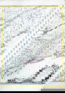
BONNE, Rigobert (1727-1791). Theatre de la Guerre en Amerique avec les Iles Antilles. Paris: Chez Lattre, 1779. Copper-engraved map, printed on two sheets joined, period hand-colouring in outline. Sheet size: 29 x 19 1/4 inches.
Scarce American Revolutionary War map, with early manuscript boundary lines added.
Shows provinces, select towns and cities, forts, Indian villages and tribal territory, and relief. Includes some shoals and banks along the coast, navigational hazards and routes of navigation in the Gulf of Mexico (Sellers and Van Ee).
Bonne first issued this map on two separate sheets in 1771, under the title Partie de l'Amerique Septentrionale. The French involvement in the war prompted much interest in maps of the region and Bonne reissued the map in 1779, as two joined sheets and with a new title as above, to meet that demand. Interestingly, this issue of the map would be published by Jean Lattre, who himself would issue the important first French map of the United States following the Treaty of Peace.
This copy with the interesting manuscript addition of boundary lines dividing the United States from Canada in the north and a boundary line along the Red River in the west and dividing Carolina from Florida.
Sellers and Van Ee, Maps and Charts of North America and the West Indies 165; McCorkle, New England in Early Printed Maps 779.2.
Buyer's Premium
- 25%
BONNE - American Revolutionary War Map, Paris 1779
Estimate $1,500 - $1,800
4 bidders are watching this item.
Get approved to bid.
Shipping & Pickup Options
Item located in New York, NY, usOffers In-House Shipping
Payment

Auction Curated By

the founder of Donald Heald Rare Books, has been in the business for 49 years and worked with some of the most renowned auction houses in the world. He is a member of the American Antiquarian Society, the Grolier Club, and the ABAA
TOP