1755 Map British & French Settlements in America
Similar Sale History
View More Items in Maps & Atlases

Related Maps & Atlases
More Items in Maps & Atlases
View MoreRecommended Transportation & Travel Collectibles
View More


Item Details
Description
Historic Maps
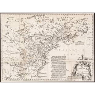
1755 French & Indian War Period Map with British & French Settlements in North America Displaying 30 Forts !
1755 French and Indian War Period, Map of North America titled, "A Map of the British and French Settlements in North America", Very Fine.
This original Map was original included as a foldout in the Universal Magazine published in 1755, displaying the United States and Canada of the period. It measures 16" x 11.75" overall with the Map's printed image size 11" x 15.25". Well printed in black on laid period paper, finely engraved with descriptive details and a large Title Cartouche at lower right. The boundaries of Virginia, North Carolina, South Carolina, and Georgia extend all the way out to the Mississippi River, although there is a very curious identification of the region south of Georgia, which is noted as "The South Part of South Carolina". Earl Granville's Property is noted, showing it extending from Albermarle Sound to the Mississippi River.
At least 30 different French and English Forts are shown and identified, including Fort Frederick at Crown Point, built by the French in 1731. One fort that this cataloger is not familiar is called "Moose Fort" at the south point of Hudson's Bay. This historic Map includes a number of additional historical notes, including the Virginia - New England border of 1606, The Carolina Charter boundary of 1665, The Limits Stipulated in 1738 for Georgia, the Bounds of Hudson's Bay by the Treaty of Utrecht, the North Bounds of New England by Chart of 1620 (extending toward the Pacific Ocean to the west of Lake Superior), etc. The course of the Ohio or "Fair" River is derived directly from an earlier map by Mitchell. The Province of Maine and Massachusetts Bay appear. East and West New Jersey are delineated, but named only New Jersey. Delaware County appears as part of Pennsylvania.
This Map has original folds as issued and a small 1" paper restoration at lower left outer margin selvege where removed from the magazine. Overall, nice in eye appeal, ready for framing and display.
Our Auction Contents:
Black History & Slavery: (Lots 1 - 63)
Abraham Lincoln Related: (Lots 64 - 74)
Historic Autographs: (Lots 75 - 235)
Colonial America: (Lots 236 - 261)
Revolutionary War: (Lots 262 - 304)
George Washington Related: (Lots 305 - 306)
Early American Guns & Weapons: (Lots 307 - 318)
Buyer's Premium
- 25%
1755 Map British & French Settlements in America
Estimate $900 - $1,200
5 bidders are watching this item.
Shipping & Pickup Options
Item located in Rancho Santa Fe, CA, usOffers In-House Shipping
Payment

Related Searches
TOP


![[MAP] BRITISH / FRENCH SETTLEMENTS NORTH AMERICA: Lodge, John. A MAP OF THE BRITISH AND FRENCH SETTLEMENTS IN NORTH AMERICA. London: circa 1750s. Handcoloured. Floral cartouche. The present example includes text detail on the English settlement claim](https://p1.liveauctioneers.com/8124/310027/165853621_1_x.jpg?height=310&quality=70&version=1700184289)


![MAPS - Maine. U.S. Gov.: Maine. U.S. Gov., [Lot of 2] Map of the Northern Part of the State of Maine and of the Adjacent British Provinces... [and] Extract from a Map of the British and French Dominions in North America, 1838](https://p1.liveauctioneers.com/6576/142214/71976779_1_x.jpg?height=310&quality=70&version=1557929467)


![South-west Europe. Swiss Savoy. British Hanover. THOMSON 1817 old antique map: TITLE/CONTENT OF MAP: [South-west sheet of] A map of Europe, with the political divisions after the Peace of Paris and Congress of Vienna The map shows south west Europe after the Congress of Vienna.](https://p1.liveauctioneers.com/5584/328641/177014448_1_x.jpg?height=310&quality=70&version=1715113718)
![Europe after the Congress of Vienna. 4 sheets. 128x106cm. THOMSON 1817 old map: TITLE/CONTENT OF MAP: A map of Europe, with the political divisions after the Peace of Paris and Congress of Vienna [4 sheets] This very large map, printed on 4 sheets, shows a re-aligned Europe after](https://p1.liveauctioneers.com/5584/328641/177014440_1_x.jpg?height=310&quality=70&version=1715113718)
![South-west & Central Europe. Switzerland includes Haute-Savoie. THOMSON 1817 map: CAPTION PRINTED BELOW PICTURE: [Europe after the Congress of Vienna - South-west sheet] An oddly-misshapen Switzerland erroneously includes what is now the French departement of Haute Savoie and part](https://p1.liveauctioneers.com/5584/328641/177014438_1_x.jpg?height=310&quality=70&version=1715113718)
![South-west & Central Europe. Switzerland includes Haute-Savoie. THOMSON 1830 map: TITLE/CONTENT OF MAP: [Europe after the Congress of Vienna - South-west sheet] An oddly-misshapen Switzerland erroneously includes what is now the French departement of Haute Savoie and part of Savoie](https://p1.liveauctioneers.com/5584/328641/177014316_1_x.jpg?height=310&quality=70&version=1715113718)
![[MAP]. SARTINE, Antoine Plan de la Barre et du Havre de Charles-Town...1778. RARE REVOLUTIONARY WAR: [MAP]. SARTINE, Antoine (1729-1801). Plan de la Barre et du Havre de Charles-Town d'apres un plan Anglois leve en 1776... Paris: Depot de la Marine for M. de Sartine, 1778. Copperplate engraving, matt](https://p1.liveauctioneers.com/197/329395/177650540_1_x.jpg?height=310&quality=70&version=1715364962)

![[Maps] Gio. Ant. Magnini, Italia, 1620: [Maps] Gio. Ant. Magnini, Italia, 1620, Giovanni Antonio Magnini. Italia, data in luce da Fabio suo figliuolo al Serenissimo Ferdinado Gonzaga Duca di Matoua edi Monserrato etc. Bologna, for Sebastian](https://p1.liveauctioneers.com/188/326797/176317457_1_x.jpg?height=310&quality=70&version=1713847031)
![[Maps] Martin Zeiler, Itinerarium Italiae, 1640: [Maps] Martin Zeiler, Itinerarium Italiae, 1640, Martini Zeilleri. Itinerarium Italiae Nov-Antiquae: oder, Raiss-Beschreibung durch Italien, Matthaus Merian, Frankfurt, 40 plates, most double-page, in](https://p1.liveauctioneers.com/188/326797/176317459_1_x.jpg?height=310&quality=70&version=1713847031)


![[MAP]. TODESCHI, Pietro. [Nova et Acurata Totius Americae Tabula auct. G.I. Blaeu] America quarta: [MAP]. TODESCHI, Pietro. [Nova et Acurata Totius Americae Tabula auct. G.I. Blaeu] America quarta pars orbis quam plerunq, nuvum orbem appellitant primo detecta est anno 1492 a Christophoro Columbo...](https://p1.liveauctioneers.com/197/329395/177650542_1_x.jpg?height=310&quality=70&version=1715364962)


