Sold2024Maps of All Texas Counties, 1885-1927Heading: (Texas) Author: Title: Maps of All Texas Counties (Latest Edition) Place Published: Tulsa, OK Publisher:Wolf & Bennet Date Published: c. 1927 Description: Approximately 25See Sold Price
Sold20221885 Two-page Railroad map of TexasCram’s 1885 double-page railroad map of Texas has exceptional printed color. Every railroad line in the state is highlighted in a heavier black line than such things as county borders, rivers anSee Sold Price
Sold2022Vintage Maps of Texas CountiesBound vintage book containing maps of Texas counties, featuring maps based off early twentieth century cartography 1.5"h x 17"w x 14"d We happily provide seamless shipping services on everything weSee Sold Price
Sold20181876 Mitchell Map of Texas -- County Map of the StateReserve Reduced! Title/Content of Map: 1876 Mitchell Map of Texas -- County Map of the State of Texas Showing also portions of the Adjoining States and Territories Date: 1876 Philadelphia CartographerSee Sold Price
Sold2020County Map of the State of Texas, 1886Excellent and detailed map of Texas colored by county and showing most of Indian Territory and New Mexico. In this map the Texas counties are still incomplete in the West. Features a large inset planSee Sold Price
Sold2017Mitchell: Antique County Map of Texas, 1873Excellent 1873 County Map of Texas by S. Augustus Mitchell. Impressive two-page County Map of the State of Texas. Map image much larger than earlier Mitchell maps. Designed and engraved by W. H. GamblSee Sold Price
Sold2020TEXAS MAP ENGRAVING PANHANDLE COUNTIES INSETFramed Texas map, hand-colored engraving on paper, a page from an atlas, plate 68, published by William Bradley, c.1880, an inset with Panhandle counties, within a geometric border, sight: approx 17.5See Sold Price
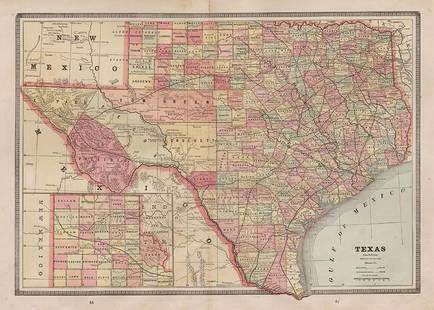
Sold2017Cram: Map of Texas, Indian Terretory, Arkansas, 1885Map: 1885 Cram Map of Texas [verso] Indian Terretory [and] Arkansas -- Texas [verso] Indian Ty. [and] Arkansas Cartographer: G Cram Year / Place: 1885, Chicago Map Dimensions: 11.8 x 17 in. A very detSee Sold Price
Sold2022Vintage County Maps of Texas Topography Maps TexasThese are vintage maps that were first made in 1915 and 1921. These maps are a great glance into the early official mapping of the Americas. The two maps in this lot are of Texas. (1) Topography map oSee Sold Price
Sold2018County Map of Texas.Reserve Reduced! Title: County Map of Texas. Publication Date: 1861 Cartographer: MITCHELL, SAMUEL AUGUSTUS (JR.) Publisher: S. Augustus Mitchell, Jr. Size: 10.75 X 13.25 Map 29 from Mitchell's New GeSee Sold Price
Sold2018County Map of Texas.Title/Content of Map: County Map of Texas. Date Printed: 1870 Cartographer: MITCHELL, SAMUEL AUGUSTUS (JR.) Material/Medium: S. Augustus Mitchell, Jr. Size: 9.25X12 Inset of Galveston Bay and VicinitySee Sold Price
Sold2017Mitchell: County Map of Texas, 1862County Map of Texas, S. Augustus Mitchell, 1862. 10.75 x 13.375 inches. Steel engraved map, with hand colored wash and outlines. Inset map of Galveston Bay, and Vicinity. Colored by county and territoSee Sold Price
Sold2018County Map of Texas, S. A. Mitchell, 1860Reserve Reduced! Authentic handcolored map of Texas with 1860 date but from Mitchell’s New General Atlas published 1864 by S. Augustus Mitchell. Detailed early map of Texas, immediately prior to theSee Sold Price
Sold2017Mitchell: Antique County Map of Texas, 1870Map: County Map of Texas Cartographer: S. A. Mitchell Place & Date: Philadelphia / 1870 Size: 13 1/4" x 10 3/4" Condition: full color; light overall age toning The beautifully detailed and colored couSee Sold Price
Sold2021Pair of Texas Maps and CompassPair of bound Texas Bureau of Economic Geology maps, to include "Atlas of Major Texas Oil Reserves" by Galloway and Ewing, "County Maps of Texas" by the State of Texas, compass 17"h x 22"w/ largest PrSee Sold Price
Sold2018Cram Map of TexasCRAM, George F (1842-1928). Railroad and county map of Texas. Lithograph with handcolor, with original black slipcase on the verso. Chicago, 1876. 17 3/4 x 24 inches sheet, 28 x 33 inches framedSee Sold Price
Sold2022SAMUEL AUGUSTUS MITCHELL JR., AN AMERICAN CIVIL WAR ERASAMUEL AUGUSTUS MITCHELL JR., AN AMERICAN CIVIL WAR ERA MAP, "County Map of Texas," CIRCA 1863, hand-colored lithograph on paper with profusely floral and fruit border, plate 34. from Mitchell's New GSee Sold Price
Sold2017Cram: Antique Map of Texas, Indian Territory, ArkansasTitle/Content of Map: 1885 Cram Map of Texas, [verso] Indian Territory and Arkansas -- Texas, [verso] Indian Ty; Arkansas Date Printed: 1885, Chicago Cartographer: G Cram Size: 12 x 17 in. This is a nSee Sold Price
Sold2023Scarce 1st ed. County map of U.S. by Tunison, 1885Interesting map of the United States showing county, state and territory boundaries as they existed in 1812. Florida referred to as "Spanish Possessions," and Mississippi Territory extends from GeorgiSee Sold Price
Sold2018Scarce 1875 hand-colored map of Texas by HardestyReserve Reduced! Attractive map of Texas and Indian Territory, colored by counties, from the very scarce Jones & Hamilton Historical Illustrated Atlas of the World published 1875 by H. H. Hardest. NicSee Sold Price
Sold2022Scarce Texas map (eastern part) from Asher & Adams,County map of Eastern Texas extends from Louisiana west to beyond San Antonio and features the railroad system of that time. Features numerous railroads still in their infancy, along with proposed futSee Sold Price
Sold2022Asher & Adams' unique RR map of Texas, 1871County map of East Texas depicted in the unique Asher & Adams’ style, without roads to highlight the presence of railroads. Extends from Louisiana west to beyond San Antonio and features the raSee Sold Price
Sold2019AN VINTAGE MAP, "Texas and Indian Territory," SECONDAN VINTAGE MAP, "Texas and Indian Territory," SECOND QUARTER 20TH CENTURY, color engraving on paper, showing counties, cities, rail lines, and rivers. 13.25" x 10.125"See Sold Price
Jun 12Dan Morphy AuctionsLOT OF 2 MAPS: LANDS IN THE COUNTIES OF RUNNELS & TOM GREEN RUNNELS COUNTY TEXAS MAPS.$200
Jun 08Simpson Galleries, LLC.TWO AMERICAN MAPS, "Texas," AND "Mexico," J.H. COLTON, NEW YORK, CIRCA 1854-1856$150
Jun 08Simpson Galleries, LLC.PAULINE (C.P. MONTAGUE) THWEATT (American/Texas 1927-2010) A PAINTING, "Texas Bluebonnets," 20TH$1,000(1 bid)
Jun 08Simpson Galleries, LLC.HSIAO-HSIA TSAI HOBBS (Chinese/American/Texas 1927-2007) A PAINTING, "Figures," 1980$100
Jun 08Simpson Galleries, LLC.A RINGLING BROS., BRANUM & BAILEY CIRCUS "TEXAS COWBOY GIANT" ADVERTISEMENT BANNER, POSSIBLY TEXAN$200(1 bid)
BonhamsMITCHELL (SAMUEL AUGUSTUS) A New Universal Atlas Containing Maps of the Various Empires, Kingdom...£1,300
5 days LeftMynt AuctionsVersailles by Gorham Sterling Silver Steak Knife Set 4pc Texas Sized Custom$10
6 days LeftJasper521854-5 Parke Profile Maps of California, Arizona and New Mexico -- Profiles from San Francisco Bay$55


![Cram: Map of Texas, Indian Terretory, Arkansas, 1885: Map: 1885 Cram Map of Texas [verso] Indian Terretory [and] Arkansas -- Texas [verso] Indian Ty. [and] Arkansas Cartographer: G Cram Year / Place: 1885, Chicago Map Dimensions: 11.8 x 17 in. A very det](https://p1.liveauctioneers.com/5584/104739/53636876_1_x.jpg?height=310&quality=70&version=1496416470)


![Cram: Antique Map of Texas, Indian Territory, Arkansas: Title/Content of Map: 1885 Cram Map of Texas, [verso] Indian Territory and Arkansas -- Texas, [verso] Indian Ty; Arkansas Date Printed: 1885, Chicago Cartographer: G Cram Size: 12 x 17 in. This is a n](https://p1.liveauctioneers.com/5584/113749/58452563_1_x.jpg?height=310&quality=70&version=1513734097)


