Sold20221885 Two-page Railroad map of TexasCram’s 1885 double-page railroad map of Texas has exceptional printed color. Every railroad line in the state is highlighted in a heavier black line than such things as county borders, rivers anSee Sold Price
Sold2017Mitchell: Antique County Map of Texas, 1873Excellent 1873 County Map of Texas by S. Augustus Mitchell. Impressive two-page County Map of the State of Texas. Map image much larger than earlier Mitchell maps. Designed and engraved by W. H. GamblSee Sold Price
Sold2021Very scarce Indian Territory/Texas, Cram 1882Scarce two-page, hand-colored map of Indian Territory and Northern Texas from the very early and scarce 1882 Cram’s Unrivaled Family Atlas of the World. All Cram atlases prior to 1883 are extremSee Sold Price
Sold20201888 Texas Railroad map by Geo. CramClean map with wide margins. Nicely centered double-page format. Full light pastel color lets railroad lines show up clearly. Very light toning to edges. 12 x 17. Reserve: $65.00 Shipping: Domestic: FSee Sold Price
Sold2022Scarce 1st ed. Northern Texas/Indian Territory, Tunison 1885Beautiful and scarce double-page chromolithographic map of Northern Texas and Indian Territory. From the 1885 edition of Tunison’s Peerless Universal Atlas of the World. WorldCat lists this atlaSee Sold Price
Sold2024Chicago Danville and Vincennes RR Gold Bond Prospectus Book-1872This is a Chicago Danville and Vincennes gold bond prospectus book dated 1872. This book has a complete route map with connecting lines on two pages inside the front cover. Has 16 total pages, with teSee Sold Price
Sold2024Cleveland and Mahoning RR 2nd Annual Report-December 20, 1854This is a Cleveland and Mahoning Railroad 2nd annual report, dated December 20, 1854. Has 24 total pages, and a complete route map dated 1853. The map is in two sections. Pages are also loose from theSee Sold Price
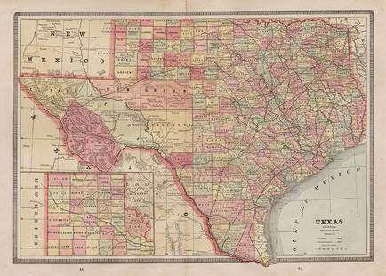
Sold2022Scarce Texas map (western part) from Asher & AdamsLarge double-page map of Western Portion of Texas with inset of extreme western tip of the state. Shows towns, proposed railroad lines and river, including the Colorado River and the Rio Grande. The fSee Sold Price
Sold20221872 map of Philadelphia - Camden by S. Augustus MitchellInteresting and informative original antique map of the two cities. Large double-page map that is nicely centered. Great detail—shows individual buildings and wharves, ferries, railroads, streetSee Sold Price
Sold2024Pennsylvania Railroad July 8, 1885 Public TimetableThis is a Pennsylvania Railroad July 8, 1885 public timetable. Has 36 paneled pages (18 to a side) and is printed on one large piece of paper. An amazing route map is on the inside, featuring the PRRSee Sold Price
Sold2023Union Pacific RR February 1892 Public TimetableThis is an amazing Union Pacific Railroad public timetable from February of 1892. It has 42 pages (48 total panels) on two long sheets. Includes a route map, maps of Chicago and St. Louis, color coverSee Sold Price
Sold2024Northern Pacific RR 17th Annual Report-Version 1-September 15, 1881This is one of two different versions of the Northern Pacific Railroad 17th annual report, dated September 15, 1881. Has 48 total pages, with an amazing full color map in the back. The map is on onionSee Sold Price
Sold2016POOR'S MANUAL OF RAILROADS, 1885'Published by J.J. Little & Co. New York, leather bound, color maps, over 1200 pages, measures 9 x 6.5 x 3 inches. We happily provide seamless in-house packing and shipping services on nearly everythinSee Sold Price
Sold2021Impressive & scarce map of N. Calif/Nevada, 1882Two-page map of Northern California, Nevada Territory and western portion of Utah from the extremely scarce 1882 Cram’s Unrivaled Family Atlas of the World. The only Cram atlas maps that were haSee Sold Price
Sold2021Scarce map of Montana/Idaho, Cram 1882Beautiful and scarce two-page map of Montana and Northern Idaho from the very scarce 1882 Cram Unrivaled Family Atlas of the World. A map rarely available, it shows the location of bygone Ft. Custer,See Sold Price
Sold2022Scarce & large map of United States, Colton 1876"Large format two-page map of the U. S. from what is likely the last atlas produced by the Colton company. Although the map is dated 1876, it was found in an 1890 Colton’s General Atlas. This aSee Sold Price
Sold2019Le Antichita di Ercolano, (11) engravingsLe Antichita di Ercolano, (11) engravings, Italian, 1757-1792, 10 single-page engravings plus a two-page map of the Bay of Naples "Cratere Maritimo, o parte del Golfo di Napoli" by P. Gaultier, 1754,See Sold Price
Sold2022Wonderful 1872 map of Alaska with orig. hand coloringVery nice and uncommon two-page map titled “Northwestern America showing the Territory ceded by Russia to the United States.” Map was published by H. H. Lloyd in 1872, just five years afteSee Sold Price
Sold2021Nice double-page map of New York, Mitchell 1860/66Title: Nice double-page map of New York, Mitchell 1860/66 Description: Impressive and colorful two-page map of the state of New York with inset maps of Buffalo, Rochester, Albany, and Troy. Hand colorSee Sold Price
Sold2023Exquisite vertical format vintage map of Germany – 1865Beautiful and large two-page map of Germany in an unusual vertical format. Covers the region from the Baltic Sea to the Adriatic Sea. This historical document shows the two great regions of Germany, PSee Sold Price
Sold20211899 vertical map of New York City & VicinityTitle: 1899 vertical map of New York City & Vicinity Description: Delightful two-page map of New York City & Vicinity, nicely centered and with wide margins. Attractive map of NYC just before the turnSee Sold Price
Sold2020AlabamaTitle: Alabama Publication Date: 1906 Cartographer: CRAM, GEORGE F. Publisher: GEO. F. CRAM Brief Descriptions: Double page railroad map with seven pages of index. A definitive railroad map of AlabamaSee Sold Price
Sold2020SDUK: South Asia, Australia and Oceania (2 sheets)The highly detailed gnomonic projection two-page map of South Asia (from the Arabian Peninsula to Indonesia), Australia, and Oceania engraved by J. & C. Walker and published by Charles Knight for theSee Sold Price
Sold2022Two railroad framed maps:Nickel Plate - the New York, Chicago, St. Louis RR, 18"x34", AND Detroit United Railways Interurban Lines, 11"x34"See Sold Price
Jun 29JM Hobby Supply and Railroad Artifact AuctionsMissouri-Kansas-Texas RR Handlan Switch Lamp$100(1 bid)
Jun 27Rail & Road AuctionsFour Lehigh & Lackawanna Railroad Annual Passes - 1884, 1885, 1886, and 1887$50
5 days LeftSimpson Galleries, LLC.A TEXAS LAND GRANT FOR I&GN RAILROAD IN POLK COUNTY, SIGNED BY ORAN ROBERTS, 17TH GOVERNOR OF TEXAS,$100(1 bid)
3 days LeftHolabird Western Americana CollectionsBooks Related to Texas History - (2) 1887, 1964 [182046]$110
BonhamsMITCHELL (SAMUEL AUGUSTUS) A New Universal Atlas Containing Maps of the Various Empires, Kingdom...£1,300
5 days LeftLeon GalleryVincenzo Maria Coronelli (1650-1718) - Uniform set of two large globe gores of the Far East₱400,000
Jun 28Rail & Road AuctionsGroup of Fourteen Railroad Stock Certificates - Illinois Central, Denver & Rio Grande Western,$30
Jun 28Rail & Road AuctionsDiverse Group of Railroad Paper and Photos - Early 1900s N&W Telegrams, W&LE Photos and Yard Maps,$30
6 days LeftAustin Auction GalleryFINE GORHAM STERLING TWO-HANDLED LOVING CUP WITH FOX HUNTING SCENES$400(1 bid)
3 days LeftHolabird Western Americana CollectionsWyoming History (3) 1899 & 1955 Reprints [182275]$200
5 days LeftSimpson Galleries, LLC.TWO AMERICAN MAPS, "Texas," AND "Mexico," J.H. COLTON, NEW YORK, CIRCA 1854-1856$150
Jun 27Rail & Road AuctionsGroup of Norfolk and Western Railroad Paper - Ink Blotters, 1926 Travel Book, and More$30
Jun 27Rail & Road AuctionsFour Baltimore and Ohio Railroad Washington DC Travel Books - 1924 to 1929$20
5 days LeftSimpson Galleries, LLC.JULIUS BIEN (1826-1909) AN AMERICAN CIVIL WAR RECONNAISSANCE MAP, "Map of Texas and Part of New$100
Jun 12Dan Morphy AuctionsLOT OF 2 MAPS: LANDS IN THE COUNTIES OF RUNNELS & TOM GREEN RUNNELS COUNTY TEXAS MAPS.$200


![Books Related to Texas History - (2) 1887, 1964 [182046] (1 of 7)](https://p1.liveauctioneers.com/2699/331494/178785549_1_x.jpg?height=282&quality=70&version=1717094654)


![Wyoming History (3) 1899 & 1955 Reprints [182275] (1 of 3)](https://p1.liveauctioneers.com/2699/331494/178785555_1_x.jpg?height=282&quality=70&version=1717094654)


