Sold2017Cram: Map of Texas, Indian Terretory, Arkansas, 1885Map: 1885 Cram Map of Texas [verso] Indian Terretory [and] Arkansas -- Texas [verso] Indian Ty. [and] Arkansas Cartographer: G Cram Year / Place: 1885, Chicago Map Dimensions: 11.8 x 17 in. A very detSee Sold Price
Sold2017Cram: Antique Map of Texas, Indian Territory, ArkansasTitle/Content of Map: 1885 Cram Map of Texas, [verso] Indian Territory and Arkansas -- Texas, [verso] Indian Ty; Arkansas Date Printed: 1885, Chicago Cartographer: G Cram Size: 12 x 17 in. This is a nSee Sold Price
Sold20221886 Cram Map of Texas [verso] Indian Territory [verso] Arkansas -- Texas [verso] Indian Ty. [verso]Title: 1886 Cram Map of Texas [verso] Indian Territory [verso] Arkansas -- Texas [verso] Indian Ty. [verso] Arkansas Cartographer: G Cram Year / Place: 1886, Chicago Map Dimension (in.): 11.8 X 17 in.See Sold Price
Sold20231884 Cram Map of Texas [verso] Indian Territory [verso] Arkansas -- Texas [verso] Indian Ty. [verso]Title: 1884 Cram Map of Texas [verso] Indian Territory [verso] Arkansas -- Texas [verso] Indian Ty. [verso] Arkansas Cartographer: G Cram Year / Place: 1884, Chicago Map Dimension (in.): 11.8 X 17 in.See Sold Price
Sold20191892 Watson/Cram Map of Texas [verso] Indian TerritoryTitle/Content of Map: 1892 Watson/Cram Map of Texas [verso] Indian Territory [verso] Arkansas -- Watson's Atlas Map of Texas [verso] Watson's Atlas Map of Indiand Ty. [verso] Watson's Atlas Map of ArkSee Sold Price
Sold20191886 Cram Map of Texas [verso] Indian Territory [verso]Title/Content of Map: 1886 Cram Map of Texas [verso] Indian Territory [verso] Arkansas -- Texas [verso] Indian Ty. [verso] Arkansas Date: 1882, Chicago Cartographer: G CramSize: 12 X 17 in. This is aSee Sold Price
Sold20201886 Cram Map of Texas [verso] Indian Territory [verso]Title/Content of Map: 1886 Cram Map of Texas [verso] Indian Territory [verso] Arkansas -- Texas [verso] Indian Ty. [verso] Arkansas Cartographer: G Cram /People's Publishing Co. Year/Place: 1886, ChicSee Sold Price
Sold20201887 Cram Map of Texas [verso] Indian Territory [verso]Title/Content of Map: 1887 Cram Map of Texas [verso] Indian Territory [verso] Arkansas -- Texas [verso] Indian Ty. [verso] Arkansas Date: 1887, Chicago Cartographer: G Cram Size: 12 X 17 in. This is aSee Sold Price
Sold20201886 Cram Map of Texas [verso] Indian Territory [verso]Title/Content of Map: 1886 Cram Map of Texas [verso] Indian Territory [verso] Arkansas -- Texas [verso] Indian Ty. [verso] Arkansas Date: 1886, Chicago Cartographer: G Cram Size: 12 X 17 in. This is aSee Sold Price
Sold20181886 Cram Map of Texas [verso] Indian Territory [and]Reserve Reduced! Title/Content of Map: 1886 Cram Map of Texas [verso] Indian Territory [and] Arkansas -- Texas [verso] Indian Ty. [and] Arkansas Date: 1886, Chicago Cartographer: G Cram Size: 11.8 x 1See Sold Price
Sold20191886 Cram Map of Texas [verso] Indian Territory [verso]Title/Content of Map: 1886 Cram Map of Texas [verso] Indian Territory [verso] Arkansas -- Texas [verso] Indian Ty. [verso] Arkansas Date: 1882, Chicago Cartographer: G Cram Size: 12 X 17 in. This is aSee Sold Price
Sold2018Cram: Antique Map of Texas, 1886Title/Content of Map: 1886 Cram Map of Texas / Arkansas and Indian Territory on Verso -- Texas; Arkansas; Indian Ty. Date Printed: 1886, Chicago Cartographer: G Cram Size: 11.8 x 17 in. Handsomely detSee Sold Price
Sold2016Cram: Map of Texas, Indian TY, Colorado, 1884Map: Texas, Indian TY, Colorado Maker: George Cram Date: 1884 Origin: Chicago Size: 11.8 x 17 inches (9.5 x 12 verso) Handsomely detailed map of Texas, with the Panhandle as insert. Colorado and IndiaSee Sold Price
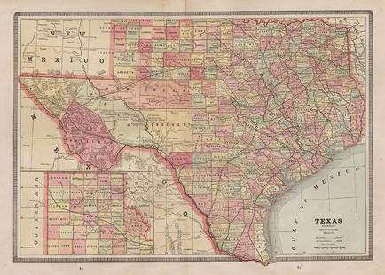
Sold20241910 Cram Map of Texas [verso] Arkansas -- Map of Texas [verso] ArkansasTitle: 1910 Cram Map of Texas [verso] Arkansas -- Map of Texas [verso] Arkansas Cartographer: G Cram Year / Place: 1910, Chicago Map Dimension (in.): 13.3 X 18.9 in. This is an excellent double-page mSee Sold Price
Sold2019George Cram’s "Rail Road Map, Texas and IndianGeorge Cram’s "Rail Road Map, Texas and Indian Territory," 1900, H.- 18 3/8 in., W.- 26 3/4 in.See Sold Price
Sold2022Scarce 1st ed. Northern Texas/Indian Territory, Tunison 1885Beautiful and scarce double-page chromolithographic map of Northern Texas and Indian Territory. From the 1885 edition of Tunison’s Peerless Universal Atlas of the World. WorldCat lists this atlaSee Sold Price
Sold2017Fullarton: Antique Map of Texas & Indian Territory 1860Map: 1860 Fullarton Map of Texas (East/Central), Indian Territory, Louisiana and Arkansas -- United States North America According to Calvin Smith& Tanner . . . South Central Section. Comprising TexasSee Sold Price
Sold20201853-4 Whipple Map of Parts of Arkansas, IndianTitle: 1853-4 Whipple Map of Parts of Arkansas, Indian Territory, Texas and New Mexico -- Map No. 1 From Fort Smith to the Rio Grande…under the direction of the Hon. Jefferson Davis, Secretary of WaSee Sold Price
Sold2022Map of Texas, Indian Terr., Mississippi, etc.- OlneyNice hand-colored school atlas map of the near Southwest. “No. 8 Mississippi, Arkansas, Louisiana, Texas, Indian Territory.” From Olney’s 1849 school atlas. Clean with a tiny spot iSee Sold Price
Sold2022Texas, Indian Terr. and SW states, Steinwehr 1870Striking map from 1870 school atlas. Shows military posts, tribes, railroads, cities and towns in Texas, Arkansas, Mississippi, "Indian Territory," and Louisiana, and public lands. Printed color. MapSee Sold Price
Sold20221885 Two-page Railroad map of TexasCram’s 1885 double-page railroad map of Texas has exceptional printed color. Every railroad line in the state is highlighted in a heavier black line than such things as county borders, rivers anSee Sold Price
Sold2021Very scarce Indian Territory/Texas, Cram 1882Scarce two-page, hand-colored map of Indian Territory and Northern Texas from the very early and scarce 1882 Cram’s Unrivaled Family Atlas of the World. All Cram atlases prior to 1883 are extremSee Sold Price
Sold20171882 Historical Hand Atlas, H. H. Hardesty Map1882 Historical Hand Atlas Illustrated, H. H. Hardesty 11.5 X 15. This Hard-to-find Atlas Has Been Rebound—it Will Look Great on Your Shelf. Several State Maps (texas/indian Territory, California/laSee Sold Price
Sold2020Texas, Indian Terratory 1888Title/Content of Map: Texas, Indian Terratory 1888 Date Printed: 1888 Material/Medium: paper Size: approx 11x14 inches Additional Info: John C. Lonngren & Son Standard Atlas of the World Reserve: $20See Sold Price
5 days LeftJasper521887 Cram Map of Texas [verso] Indian Territory [verso] Arkansas -- Texas [verso] Indian Ty. [verso]$95
5 days LeftJasper521898 Rand McNally Map of Texas [verso] Indian Territory and Oklahoma -- Texas [verso] Oklahoma and$70
Jun 12Dan Morphy AuctionsINDIAN TERRITORY - DEPARTMENT OF THE INTERIOR GENERAL LAND OFFICE, C.1883$100
Jun 12Dan Morphy AuctionsPLATE CXIII. MAP OF INDIAN TERRITORY SHOWING DISTRIBUTION OF WOODLAND” FROM THE TWENTY-FIRST$100
6 days LeftPotter & Potter AuctionsSTORM, Mark. Official Texas Brags Map of North America. 194...$200(1 bid)
May 21BonhamsThe War in India: Despatches of the Rt. Hon. Lt. General Viscount Hardinge, Governor-General of ...£1,200
Jun 12Dan Morphy AuctionsMAP OF THE CHOCTAW NATION, INDIAN TERRITORY - COAL AND ASPHALT SEGREGATION 1903$150
Jun 12Dan Morphy AuctionsMAP OF THE CHOCTAW NATION, INDIAN TERRITORY - COAL AND ASPHALT SEGREGATION 1903$100


![Cram: Map of Texas, Indian Terretory, Arkansas, 1885: Map: 1885 Cram Map of Texas [verso] Indian Terretory [and] Arkansas -- Texas [verso] Indian Ty. [and] Arkansas Cartographer: G Cram Year / Place: 1885, Chicago Map Dimensions: 11.8 x 17 in. A very det](https://p1.liveauctioneers.com/5584/104739/53636876_1_x.jpg?height=310&quality=70&version=1496416470)


![Cram: Antique Map of Texas, Indian Territory, Arkansas: Title/Content of Map: 1885 Cram Map of Texas, [verso] Indian Territory and Arkansas -- Texas, [verso] Indian Ty; Arkansas Date Printed: 1885, Chicago Cartographer: G Cram Size: 12 x 17 in. This is a n](https://p1.liveauctioneers.com/5584/113749/58452563_1_x.jpg?height=310&quality=70&version=1513734097)
![1886 Cram Map of Texas [verso] Indian Territory [verso] Arkansas -- Texas [verso] Indian Ty. [verso]: Title: 1886 Cram Map of Texas [verso] Indian Territory [verso] Arkansas -- Texas [verso] Indian Ty. [verso] Arkansas Cartographer: G Cram Year / Place: 1886, Chicago Map Dimension (in.): 11.8 X 17 in.](https://p1.liveauctioneers.com/5584/270923/141842451_1_x.jpg?height=310&quality=70&version=1670433092)
![1884 Cram Map of Texas [verso] Indian Territory [verso] Arkansas -- Texas [verso] Indian Ty. [verso]: Title: 1884 Cram Map of Texas [verso] Indian Territory [verso] Arkansas -- Texas [verso] Indian Ty. [verso] Arkansas Cartographer: G Cram Year / Place: 1884, Chicago Map Dimension (in.): 11.8 X 17 in.](https://p1.liveauctioneers.com/5584/304136/162284641_1_x.jpg?height=310&quality=70&version=1696356363)
![1892 Watson/Cram Map of Texas [verso] Indian Territory: Title/Content of Map: 1892 Watson/Cram Map of Texas [verso] Indian Territory [verso] Arkansas -- Watson's Atlas Map of Texas [verso] Watson's Atlas Map of Indiand Ty. [verso] Watson's Atlas Map of Ark](https://p1.liveauctioneers.com/5584/133765/67935052_1_x.jpg?height=310&quality=70&version=1546475054)
![1886 Cram Map of Texas [verso] Indian Territory [verso]: Title/Content of Map: 1886 Cram Map of Texas [verso] Indian Territory [verso] Arkansas -- Texas [verso] Indian Ty. [verso] Arkansas Date: 1882, Chicago Cartographer: G CramSize: 12 X 17 in. This is a](https://p1.liveauctioneers.com/5584/137769/69881200_1_x.jpg?height=310&quality=70&version=1552435690)
![1886 Cram Map of Texas [verso] Indian Territory [verso]: Title/Content of Map: 1886 Cram Map of Texas [verso] Indian Territory [verso] Arkansas -- Texas [verso] Indian Ty. [verso] Arkansas Cartographer: G Cram /People's Publishing Co. Year/Place: 1886, Chic](https://p1.liveauctioneers.com/5584/175972/88577718_1_x.jpg?height=310&quality=70&version=1597183226)
![1887 Cram Map of Texas [verso] Indian Territory [verso]: Title/Content of Map: 1887 Cram Map of Texas [verso] Indian Territory [verso] Arkansas -- Texas [verso] Indian Ty. [verso] Arkansas Date: 1887, Chicago Cartographer: G Cram Size: 12 X 17 in. This is a](https://p1.liveauctioneers.com/5584/164510/83043299_1_x.jpg?height=310&quality=70&version=1585094571)
![1886 Cram Map of Texas [verso] Indian Territory [verso]: Title/Content of Map: 1886 Cram Map of Texas [verso] Indian Territory [verso] Arkansas -- Texas [verso] Indian Ty. [verso] Arkansas Date: 1886, Chicago Cartographer: G Cram Size: 12 X 17 in. This is a](https://p1.liveauctioneers.com/5584/161241/81395745_1_x.jpg?height=310&quality=70&version=1581460166)
![1886 Cram Map of Texas [verso] Indian Territory [and]: Reserve Reduced! Title/Content of Map: 1886 Cram Map of Texas [verso] Indian Territory [and] Arkansas -- Texas [verso] Indian Ty. [and] Arkansas Date: 1886, Chicago Cartographer: G Cram Size: 11.8 x 1](https://p1.liveauctioneers.com/5584/128997/65616692_1_x.jpg?height=310&quality=70&version=1539125359)
![1886 Cram Map of Texas [verso] Indian Territory [verso]: Title/Content of Map: 1886 Cram Map of Texas [verso] Indian Territory [verso] Arkansas -- Texas [verso] Indian Ty. [verso] Arkansas Date: 1882, Chicago Cartographer: G Cram Size: 12 X 17 in. This is a](https://p1.liveauctioneers.com/5584/144578/73088219_1_x.jpg?height=310&quality=70&version=1561513819)


![1910 Cram Map of Texas [verso] Arkansas -- Map of Texas [verso] Arkansas: Title: 1910 Cram Map of Texas [verso] Arkansas -- Map of Texas [verso] Arkansas Cartographer: G Cram Year / Place: 1910, Chicago Map Dimension (in.): 13.3 X 18.9 in. This is an excellent double-page m](https://p1.liveauctioneers.com/5584/316358/169716567_1_x.jpg?height=310&quality=70&version=1706046384)


![1887 Cram Map of Texas [verso] Indian Territory [verso] Arkansas -- Texas [verso] Indian Ty. [verso] (1 of 3)](https://p1.liveauctioneers.com/5584/328338/176911685_1_x.jpg?height=282&quality=70&version=1715113718)

![1898 Rand McNally Map of Texas [verso] Indian Territory and Oklahoma -- Texas [verso] Oklahoma and (1 of 2)](https://p1.liveauctioneers.com/5584/328338/176911581_1_x.jpg?height=282&quality=70&version=1715113718)