Sold20201946 Greyhound US Route Map -- Map of Greyhound LinesTitle/Content of Map: 1946 Greyhound US Route Map -- Map of Greyhound Lines and Principal Connecting Lines Cartographer: Greyhound Year/Place: 1946 c. Size: 15 X 21.5 in. unfolded This is a nice foldiSee Sold Price
Sold20221946 Greyhound US Route Map -- Map of Greyhound Lines and Princial Connecting LinesTitle: 1946 Greyhound US Route Map -- Map of Greyhound Lines and Princial Connecting Lines Cartographer: Greyhound Year / Place: 1946 c. Map Dimension (in.): 15 X 21.5 in. unfolded This is a nice foldSee Sold Price
Sold20191946 Greyhound US Route Map -- Map of Greyhound LinesTitle/Content of Map: 1946 Greyhound US Route Map -- Map of Greyhound Lines and Princial Connecting Lines Date: 1946Cartographer: Greyhound Size: 15 X 21.5 in. unfolded This is a nice folding map showSee Sold Price
Sold20181946 Greyhound Bus Line Pictorial US Map -- MapaTitle/Content of Map: 1946 Greyhound Bus Line Pictorial US Map -- Mapa Ilustrado Greyhound de Los Estados Unidos Date: 1946 Cartographer: Greyhound Co. Size: 18 x 23. 8 in. This is a nice pictorial maSee Sold Price
Sold2016Greyhound Lines Bus Route Map Poster, 1937Approx. 30" x 20". Not linen backed. Rolled. Some light edge and corner wear, small edge tears.See Sold Price
Sold2022KV. Greyhound  / A Good-Natured Map of The United States. 1...KV. Greyhound  / A Good-Natured Map of The United States. 1934. Pictorial map of The United States with the routes of the Greyhound bus lines in black and numerous illustrations of regional attraSee Sold Price
Sold2015"Good-Natured" U.S. Map by Greyhound BusThis "Good Natured" map of the United States and a "Guide to the Wonderful West" was issued compliments of Greyhound and Union Pacific Stages. The litho was made in the USA by Sunset Press in San FranSee Sold Price
Sold2019Greyhound metal file cabinet with route mapsBox is full of route maps and all kinds of literature thousands of pieces. Thousands of route stop paper literature's throughout the United States and Canada. Boxes 12 in wide 23 1/2 in Long 8 1/2 incSee Sold Price
Sold2019Vintage Bus Travel Ephemera and PhotosIncluding "Greyhound Lines, several "Blue Ridge Lines". several New York City bus maps and various glossy bus photos from the early 20th century.See Sold Price
Sold2019U S Coast Survey 1896 Map. Missouri & Kansas"Sketch showing Route Line of Spirit Levels" Lithograph Map Published 1896, Washington for "U.S. Coast and Geodetic Survey" Folds as issued. Rare. Paper Size: 16 x 11.5 inch (40 x 29cm) Good ConditionSee Sold Price
Sold2020U S Coast Survey 1896 Map. Missouri & Kansas"Sketch showing Route Line of Spirit Levels from Jefferson City Mo. To Holliday, Kans" Lithograph Map Published 1896, Washington for "U.S. Coast and Geodetic Survey" Folds as issued. Rare. Paper Size:See Sold Price
Sold20221940s American Airlines US Route Map -- American Airlines System MapTitle: 1940s American Airlines US Route Map -- American Airlines System Map Cartographer: American Airlines (General Drafting Co.) Year / Place: 1940s c. Map Dimension (in.): 24 X 32 in. Ths is an attSee Sold Price
Sold2022US DEPARTMENT OF DEFENSE. WORLD WAR 2, SUMATRA, INDONESIA AND DUTCH EAST INDIES MAPS (1944-1946)US DEPARTMENT OF DEFENSE. WORLD WAR 2, SUMATRA, INDONESIA AND DUTCH EAST INDIES MAPS (1944-1946). US Army Map Service. Eight maps from Dutch Sumatra and Timor: Gle Jeueng (paper) and Lho'Nga (paper) eSee Sold Price
Sold2022US DEPARTMENT OF DEFENSE. WORLD WAR 2, SUMATRA, INDONESIA AND DUTCH EAST INDIES MAPS (1943-1946)US DEPARTMENT OF DEFENSE. WORLD WAR 2, SUMATRA, INDONESIA AND DUTCH EAST INDIES MAPS (1943-1946). US Army Map Service. Eight maps, from Dutch East Indies: Dutch Timor, Isle of Roti; Portuguese Timor;See Sold Price
Sold20181947 World Route Map of US Flag Airlines --Title/Content of Map: 1947 World Route Map of US Flag Airlines -- International Air Routes of U.S. Flag Carriers as of April, 1947 Date: 1947 Cartographer: Anonymous Size: 10.9 x 21 in. This fascinatiSee Sold Price
Sold2023Delaware and Hudson RR Framed Bridge Line Route Map 1823-1973This large framed poster/map is from the Delaware and Hudson Railroad and shows their routes for both canal and railroad from 1823 to 1973, between New England and Canada. An excellent, full color pieSee Sold Price
Sold2024Nine United Air Lines Paper Items - Travel Brochures, Guides, Maps, Information Packet, Flight Log,An assorted collection of paper for United Air Lines including a 1946 Maps of the Main Line Airway with 35 pages of information, maps, illustrations, and photographs. 1951 Air Maps of Main Line AirwaySee Sold Price
Sold2018American Airlines Route Map World's Fair Line 1939American Airlines Route Map World's Fair Line 1939See Sold Price
Sold2024Chicago Danville and Vincennes RR Gold Bond Prospectus Book-1872This is a Chicago Danville and Vincennes gold bond prospectus book dated 1872. This book has a complete route map with connecting lines on two pages inside the front cover. Has 16 total pages, with teSee Sold Price
Sold2022TRAIN EPHEMERA COLLECTIONIncludes The Pullman Company ticket stubs dated 1929, train route maps, a Porto Rico Line ships menu 1922, Boston to Maine Railroad magazine, & more.See Sold Price
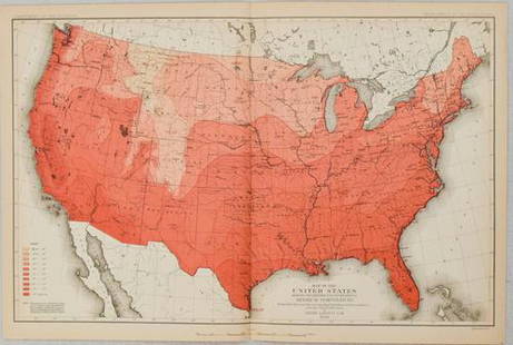
Sold20211880 Gannett Climate Map of the US with IsothermalTitle: 1880 Gannett Climate Map of the US with Isothermal Minimum Temperature Lines -- Map of the United states Showing the Distribution of Lines of Minimum Temperature… Cartographer: H Gannett / DeSee Sold Price
Sold2022VINTAGE UNITED AIR LINES AIR MAP & COPENHAGEN MAPVINTAGE UNITED AIR LINES AIR MAP & COPENHAGEN MAP Get all dressed up and fly the friendly skies back in time. See the travel routes for United Air Lines to Hawaii, Los Angeles, SeattSee Sold Price
Sold2018United Airlines Route Map A Gay Geography of Main LineUnited Air Lines. A Gay Geography of the Main Line Airway. The Main Line Mid-Continental Airway published in 1939 route map. See Sold Price
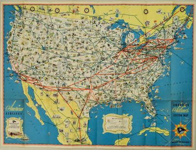
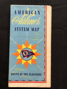
Sold2018American Airlines System Map Route Of The Flagships 194American Airlines System Map Route Of The Flagships 1946See Sold Price
6 days LeftJasper521857 Emory Maps of Magnetic Declanation Lines and Sections along the US Mexican Border -- United$45
Jun 20The Ross Art GroupOriginal Vintage United Air Lines Hawaii Woman with Lei Poster by Stan Galli$600
6 days LeftJasper521893 Civil War Map of Siege of Yorktown, Battle of Siloh and Army of Ohio Operations -- Plan of$55
6 days LeftJasper521861 Map of Western US -- Reduced Section of a General Map of North America, Drawn from the Best$40
6 days LeftJasper521861 View of Weber River near Salt Lake City -- Second or Sheeprock Canon of Weber River$35
2 days LeftFreeman's | Hindman[CIVIL WAR]. Archive of items related to Elisha Hunt RHODES (1842-1917), 2nd Rhode Island Volunteer$750
Jun 07Freeman's | Hindman[MORMONS]. MILLROY & HAYES (fl. 1899). Route of the Mormon Pioneers from Nauvoo to Great Salt Lake,$300
Jun 23Schilb Antiquarian Rare Books1877 Geology Geography Surveys 1ed Nevada Wyoming Utah George Wheeler US West 2v$1


![[CIVIL WAR]. Archive of items related to Elisha Hunt RHODES (1842-1917), 2nd Rhode Island Volunteer (1 of 6)](https://p1.liveauctioneers.com/197/329785/177758366_1_x.jpg?height=282&quality=70&version=1715625218)

![[MORMONS]. MILLROY & HAYES (fl. 1899). Route of the Mormon Pioneers from Nauvoo to Great Salt Lake, (1 of 2)](https://p1.liveauctioneers.com/197/329395/177650560_1_x.jpg?height=282&quality=70&version=1715364962)


