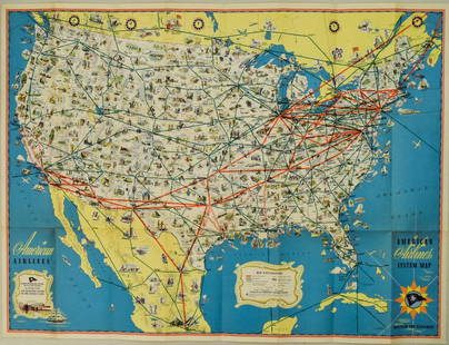
Sold20221940s American Airlines US Route Map -- American Airlines System MapTitle: 1940s American Airlines US Route Map -- American Airlines System Map Cartographer: American Airlines (General Drafting Co.) Year / Place: 1940s c. Map Dimension (in.): 24 X 32 in. Ths is an attSee Sold Price
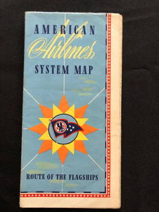
Sold2018American Airlines System Map Route Of The Flagships 194American Airlines System Map Route Of The Flagships 1946See Sold Price
Sold2022Pan American Airlines Clipper Club Pilot's 1940's Map.Showing routes flown, framed, 19 x 33 inches.See Sold Price
Sold2019Pan American Airways System. World Map 1956.Pan American Airways System. World Map 1956. Art by John Brown, cartography by John Philip. Offset poster showing the airline’s routes across the world. 34 x 60”. Inpainting to lower image, minorSee Sold Price
Sold2018Pan American Airways System. World Map 1968Pan American Airways System. World Map 1968. Art by John Brown, cartography by John Philip. Offset poster showing the airline's routes across the world. Linen backed. 18 x 32". A.See Sold Price
Sold20231950s American Airlines Route Map -- American Airlines Route MapTitle: 1950s American Airlines Route Map -- American Airlines Route Map Cartographer: American Airlines Year / Place: 1950s Map Dimension (in.): 12.5 X 19.2 in. joined This nice, large pictorial routeSee Sold Price
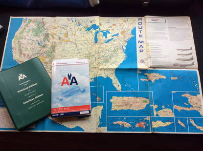
Sold2023Vintage American Airlines Route Map, American Airline Trip Book and BinderVintage American Airlines Route Map, American Airline Trip Book and BinderSee Sold Price
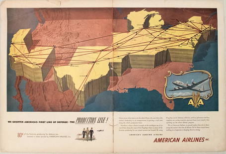
Sold20191949 American Airlines Route Map AdTitle/Content of Map: 1949 American Airlines Route Map Ad Date: 1949Cartographer: American Airlines Size: 13.6 X 21 in. when joined This is an attractive ad highlightingAmerican Airlines routes - servSee Sold Price
Sold2023PAN AMERICAN AIRLINES ROUTE MAP. "Fastest way between… USA & Latin America" 1935Title: PAN AMERICAN AIRLINES ROUTE MAP. "Fastest way between… USA & Latin America" 1935 Description: Consult this map for fastest way between all points in the United States and Latin America' bSee Sold Price
Sold2018American Airlines Route Map World's Fair Line 1939American Airlines Route Map World's Fair Line 1939See Sold Price
Sold2018American Airlines System Map 1952American Airlines System Map 1952, 33 1/2" x24"See Sold Price
Sold2018American Airlines System Maps Circa 1960's/70's?American Airlines System Maps Circa 1960's/70'sSee Sold Price
Sold20181957 Route Map of Pan American Airline to Mexico,Title/Content of Map: 1957 Route Map of Pan American Airline to Mexico, Central America and Part of Caribbean -- Pan American Flight Map [to] Mexico & Central America Date: 1957 Cartographer: PanAm SiSee Sold Price
Sold20171950 Map of PanAm Airline Caribbean Routes1950 Map of PanAm Airline Caribbean Routes -- Pan American Flight Map New York and Caribbean. PanAm, 1950 ca., A nice folding map of Pan American Airline routes to Caribbean from New York City & MiamiSee Sold Price
Sold20221947 New England Airport Map & Circa 60's American AirlinesSystem Map. New England Map has some tearing. Please see photos and come to the 2 day preview for condition.See Sold Price
Sold2018Two Large Maps of the WorldTwo Large Maps of the World, American Air Lines & Menier Chocolate. American Airlines Air World Map, showing the distances to various cities and locations from the geographical center of the United StSee Sold Price
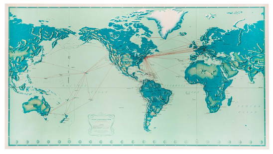
Sold20181947 World Route Map of US Flag Airlines --Title/Content of Map: 1947 World Route Map of US Flag Airlines -- International Air Routes of U.S. Flag Carriers as of April, 1947 Date: 1947 Cartographer: Anonymous Size: 10.9 x 21 in. This fascinatiSee Sold Price
Sold2018Pan American Airways Circa 1950's System Route MapPan American Airways Circa 1950's System Route MapSee Sold Price
Sold2022[MAPS]. -- [AIRLINES]. A dozen mid-20th century airline[MAPS]. -- [AIRLINES]. A dozen mid-20th century airline maps. Brochures for Air France, Air Rhodesia, American Airlines, British Airways, Hawaiian Airlines, Mexicana de Aviacion, Northwest Orient AirlSee Sold Price
Sold2017Group of 10 Vintage Travel Maps Featuring AirlinesDelta, Pan American, American Airlines, and MoreSee Sold Price
Sold2023(6) VINTAGE BARBIE OUTFITS(6) VINTAGE BARBIE OUTFITS (6) outfits including Open Road (sweater-needs snap fixed,pants,coat,hat,red cork shoes,road map,red glasses), Wedding Date (gown, jewelry,veil), American Airlines (bodysuitSee Sold Price
Jun 20The Ross Art GroupOriginal Vintage United Air Lines Hawaii Woman with Lei Poster by Stan Galli$600
Jun 20The Ross Art GroupOriginal Vintage United Air Lines Southern California Poster by Stan Galli$500
Jun 20The Ross Art GroupOriginal Vintage United Air Lines Poster by Stan Galli c1960 - Three Riders on Horses$600
Jun 20The Ross Art GroupOriginal Vintage Air France World Route Map Vickers Viscount Poster 1956 Constellation$600
Jun 20The Ross Art GroupOriginal Vintage Fly TWA Jets India Pink Elephant Poster by David Klein c1960$600(1 bid)
Jun 23Schilb Antiquarian Rare Books1877 Geology Geography Surveys 1ed Nevada Wyoming Utah George Wheeler US West 2v$1
1 day LeftFreeman's | Hindman[CIVIL WAR]. Archive of items related to Elisha Hunt RHODES (1842-1917), 2nd Rhode Island Volunteer$750
2 days LeftWatches of KnightsbridgeA GENTLEMAN'S SMALL SIZE WITTNAUER WEEMS PILOTS WRIST WATCH CIRCA 1940, U.S. PAT. 2008734 FOR THE£800
Jun 08Simpson Galleries, LLC.J.H. Young (1792-1870) AN AMERICAN FEDERAL PERIOD MAP, "Mitchell's Travellers Guide Through the$500
Jun 08Early American History Auctions1853 Map, Basin of the St. Lawrence, by T. Keefer showing Natural + Artificial North American Routes$220


![1957 Route Map of Pan American Airline to Mexico,: Title/Content of Map: 1957 Route Map of Pan American Airline to Mexico, Central America and Part of Caribbean -- Pan American Flight Map [to] Mexico & Central America Date: 1957 Cartographer: PanAm Si](https://p1.liveauctioneers.com/5584/124256/63192867_1_x.jpg?height=310&quality=70&version=1530636078)


![[MAPS]. -- [AIRLINES]. A dozen mid-20th century airline: [MAPS]. -- [AIRLINES]. A dozen mid-20th century airline maps. Brochures for Air France, Air Rhodesia, American Airlines, British Airways, Hawaiian Airlines, Mexicana de Aviacion, Northwest Orient Airl](https://p1.liveauctioneers.com/928/230548/119288810_1_x.jpg?height=310&quality=70&version=1639776029)


![[CIVIL WAR]. Archive of items related to Elisha Hunt RHODES (1842-1917), 2nd Rhode Island Volunteer (1 of 6)](https://p1.liveauctioneers.com/197/329785/177758366_1_x.jpg?height=282&quality=70&version=1715625218)


