Sold2023PAN AMERICAN AIRLINES ROUTE MAP. "Fastest way between… USA & Latin America" 1935Title: PAN AMERICAN AIRLINES ROUTE MAP. "Fastest way between… USA & Latin America" 1935 Description: Consult this map for fastest way between all points in the United States and Latin America' bSee Sold Price
Sold20181957 Route Map of Pan American Airline to Mexico,Title/Content of Map: 1957 Route Map of Pan American Airline to Mexico, Central America and Part of Caribbean -- Pan American Flight Map [to] Mexico & Central America Date: 1957 Cartographer: PanAm SiSee Sold Price
Sold20171950 Map of PanAm Airline Caribbean Routes1950 Map of PanAm Airline Caribbean Routes -- Pan American Flight Map New York and Caribbean. PanAm, 1950 ca., A nice folding map of Pan American Airline routes to Caribbean from New York City & MiamiSee Sold Price
Sold20231950s PanAm Route Map of South America's East Coast -- Pan American Flight Map, South America EastTitle: 1950s PanAm Route Map of South America's East Coast -- Pan American Flight Map, South America East Coast Cartographer: PanAm Year / Place: late 1950s c. Map Dimension (in.): 23.5 X 16.8 in. folSee Sold Price
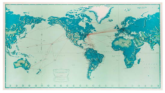
Sold2019Pan American Airways System. World Map 1956.Pan American Airways System. World Map 1956. Art by John Brown, cartography by John Philip. Offset poster showing the airline’s routes across the world. 34 x 60”. Inpainting to lower image, minorSee Sold Price
Sold2022Pan American Airlines Clipper Club Pilot's 1940's Map.Showing routes flown, framed, 19 x 33 inches.See Sold Price
Sold2018Pan American Airways System. World Map 1968Pan American Airways System. World Map 1968. Art by John Brown, cartography by John Philip. Offset poster showing the airline's routes across the world. Linen backed. 18 x 32". A.See Sold Price
Sold2018Jean Michel Basquiat Jean-Michel Basquiat AmericanJean-Michel Basquiat 14 1/2” x 12 3/4” Mixed media on hard paperboard.Private Collection Latin America.Provenance Included. Attributed to: Jean-Michel Basquiat (December 22, 1960 - August 12, 1988See Sold Price
Sold2021PRESENTATION MODEL OF AN AMERICAN PACKET SHIP ON THEPRESENTATION MODEL OF AN AMERICAN PACKET SHIP ON THE WAYSAmerica, Early 20th CenturyHull built up in plank-on-frame construction, with a copper-plated bottom, white waterline and black topsides. StemSee Sold Price
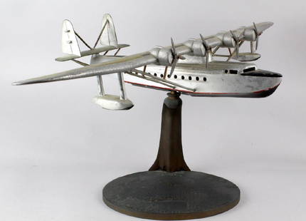
Sold20181930s Travel Agent Pan Am Airplane Flying Clipper Large1930s Travel Agent Pan American Airplane on the original bronze stand "Routes of the Flying Clipper Ships". Impressive heavy and well made all metal 4 prop airplane used to enitce exotic air travel toSee Sold Price
Sold20241777 Revolutionary War Map America Septentrionalis1777 hand-colored map published by Homann Heirs, Nuremberg, showing the British colonies in North American, published in the midst of the American Revolution, entitled "America Septentrionalis a DominSee Sold Price
Sold201819th C. Northwest Coast Haida / Tlingit Bear Totem**Originally Listed At $2500** North America, Pacific Northwest (USA and Canada), Native American, Haida or Tlingit peoples, ca. late 19th century CE. A finely carved and painted wood totem pole depicSee Sold Price
Sold20211721 Map of America With California as an IslandHistoric Maps 1721 Hand-Colored "A New Map of America from the Latest Observations" with "California" Shown as an Island 1721 Hand-Colored Engraved Western Hemisphere Map titled, "A New Map of AmericaSee Sold Price
Sold2021c 1730 Seutter Map: Novi Belgii, in America ...Historic Maps c. 1730 Historic Rare Earlier State of Seutter's Important American Northeast Map & New York City Restitutio View c. 1730 Hand-Colored Copper-Engraved Map titled, "Recens Edita totius NoSee Sold Price
Sold2021Early 20th C. American Wood Biplane PropellerNorth America, USA, from Clover Field Airport, Santa Monica, California (the first airport in that city), ca. 1917 to 1922 CE. An absolutely gorgeous piece of early aviation history, this is a massiveSee Sold Price
Sold2023Original Vintage Indochine Francaise Map by Lucien Boucher 1935 Vietnam Laos CambodiaAs one can only imagine, travel in the Far East in the 1920's must have been a challenging adventure. This well illustrated map poster by master artist, Lucien Boucher shows the various routes once coSee Sold Price
Sold2016Jim Dine, ‘The Foreign Plowman’, Woodcut with Etching,Woodcut, soft-ground etching, and spit-bite etching with hand coloring on 5 panels of Arches paper USA, 1988 Jim Dine (b. 1935) – American Pop artist Published by Pace Editions, New York, NY SignedSee Sold Price
Sold2016Jim Dine, ‘Red Dancer on the Western Shore', Woodcut,Woodcut and spit bite etching in colors over two sheets of Arches Cover paper joined with archival tape on verso, as published. USA, 1988 Jim Dine (b. 1935) – American Pop artist Published by GraphiSee Sold Price
Sold2016Jim Dine, ‘My Nights in Santa Monica’, Signed, Etching,Etching in color with engraving, aquatint, graveure, soft ground and drypoint on paper USA, 1986 Jim Dine (b. 1935) – American Pop artist Published by Pace Editions, New York Printed by GraphicstudiSee Sold Price
Sold2020Russel Wright, Reclining 'American Modern' Lounge ChairRussel Wright Reclining 'American Modern' lounge chair, ca. 1935 Maple, fabric. Manufactured by Conant Ball, USA. Underside stamped with Conant Ball American Modern roundel.See Sold Price
Sold2016Alexander Girard Sofa, model 66303, USA, ca. 1967Cast aluminum, vinyl, upholstery USA, ca. 1967 Alexander Girard (1907-1993) – American architect and designer Produced for Herman Miller for Braniff Airlines For reference, see “Alexander Girard DSee Sold Price
Sold2024Salvador Corratge (1928 - 2014) Latin AmericanSalvador Corratge (1928 - 2014) Acrylic on canvas, signed lower right "S. Coratge" and on verso signed and dedicated in 2010 in USA. Paitning measures 22 x 28 and 25 x 31 inches w/ frame. Salvador CorSee Sold Price
Sold2021Pattyn Products, Table lamp, model 310Pattyn Products Table lamp, model 310 USA, c. 1935aluminum, Bakelite, frosted glass, brass 20 h × 8 dia in (51 × 20 cm) Literature: The Machine Age in America 1See Sold Price
4 days LeftJasper52SOUTH AMERICA. La Plata & Chilé. Chile Argentina Uruguay Bolivia. SDUK 1851 map$40
4 days LeftJasper52SOUTH AMERICA.La Plata and Chilé.Chile Argentina Uruguay Bolivia.SDUK 1844 map$40
Featured4 days LeftJasper52Johnson's South America. Bolivia with Littoral. Navigators' routes 1861 map$130
4 days LeftJasper52SOUTH AMERICA COMMERCIAL.Steamer routes Telegraph cables Railways Canal 1901 map$8
Featured4 days LeftJasper52Americae Australis / Peruana by Bertius / Langenes. South America 1603 old map$280
4 days LeftJasper52NW SOUTH AMERICA. Colombia Venezuela Ecuador Peru Bolivia Brazil. Lima 1907 map$10
4 days LeftJasper52Central America. Mexico Chiapa, Tabasco & Yucatan. Belize &c. SWANSTON 1860 map$60


![1957 Route Map of Pan American Airline to Mexico,: Title/Content of Map: 1957 Route Map of Pan American Airline to Mexico, Central America and Part of Caribbean -- Pan American Flight Map [to] Mexico & Central America Date: 1957 Cartographer: PanAm Si](https://p1.liveauctioneers.com/5584/124256/63192867_1_x.jpg?height=310&quality=70&version=1530636078)