Sold20211880 Gannett Climate Map of the US with IsothermalTitle: 1880 Gannett Climate Map of the US with Isothermal Minimum Temperature Lines -- Map of the United states Showing the Distribution of Lines of Minimum Temperature… Cartographer: H Gannett / DeSee Sold Price
Sold20201890 c. World Climate Map -- Isothermal Curves andTitle/Content of Map: 1890 c. World Climate Map -- Isothermal Curves and Zones of Physical Climate Cartographer: Anonymous Year/Place: 1890 c. Size: 10.4 x 17.7 in. This is a very interesting world maSee Sold Price
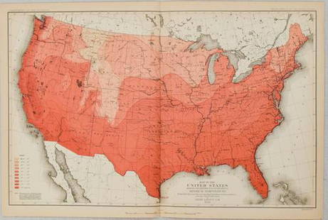
Sold20201880 US Government Map of US Population Distribution --Title/Content of Map: 1880 US Government Map of US Population Distribution -- Distribution of the Population (Excluding Indians Not Taxed) Cartographer: US Department of the Interior Year/Place: 1880See Sold Price
Sold20181880 Gray US Map -- Gray's New Map of the United StatesReserve Reduced! Title/Content of Map: 1880 Gray US Map -- Gray's New Map of the United States Date: 1880, Philadelphia Cartographer: F Gray Size: 15.5 x 26.7 in. A very nice large US map, showing greSee Sold Price
Sold20181880 Gray US Map -- Gray's New Map of the United StatesTitle/Content of Map: 1880 Gray US Map -- Gray's New Map of the United States Date: 1880, Philadelphia Cartographer: F Gray Size: 15.5 x 26.7 in. A very nice larger US map, showing great deal of topogSee Sold Price
Sold20191880 Gray US Map -- Gray's New Map of the United StatesTitle/Content of Map: 1880 Gray US Map -- Gray's New Map of the United States Date: 1880, Philadelphia Cartographer: F Gray Size: 15.5 x 26.7 in. A very nice large US map, showing great deal of topogrSee Sold Price
Sold20221880 US Census Map of Oats Production -- Map of the United States Showing the Average Yield of OatsTitle: 1880 US Census Map of Oats Production -- Map of the United States Showing the Average Yield of Oats per Acre… Cartographer: US Census Bureau Year / Place: 1880, Boston Map Dimension (in.)See Sold Price
Sold20231880 US Census Map of Corn Production per Capita -- Map of the United States Showing theTitle: 1880 US Census Map of Corn Production per Capita -- Map of the United States Showing the Distribution of Production of Indian Corn in Bushels per Capita… Cartographer: US Census Bureau YeSee Sold Price
Sold20231880 US Census Map of Wheat Production per Capita -- Map of the United States Showing theTitle: 1880 US Census Map of Wheat Production per Capita -- Map of the United States Showing the Distribution of Production of Wheat in Bushels per Capita… Cartographer: US Census Bureau Year /See Sold Price
Sold20231880 US Census Map of Oats Production per Capita -- Map of the United States Showing theTitle: 1880 US Census Map of Oats Production per Capita -- Map of the United States Showing the Distribution of Production of Oats in Bushels per Capita… Cartographer: US Census Bureau Year / PlSee Sold Price
Sold20231880 US Census Map of Barley Production -- Map of the United States Showing the Average Yield ofTitle: 1880 US Census Map of Barley Production -- Map of the United States Showing the Average Yield of Barley per Acre… Cartographer: US Census Bureau Year / Place: 1880, Boston Map Dimension (See Sold Price
Sold2018With State Seals /Presidents Surrounding U.S. MapAtwood, J. M. (1818-c. 1880) & Phelps, Humphrey (fl. c. 1830-1860). Phelps's National Map of the United States, a Travellers Guide... Engraved map. Ensign & Thayer, 1851. 20 ½" x 25 ¾" sheet. "ESee Sold Price
Sold20221823 Woodbridge Maps of Climate, Vegetation and AnimalsTitle: 1823 Woodbridge Maps of Climate, Vegetation and Animals of the World -- Isothermal Chart or View of Climates & Production… Cartographer: W. Woodbridge Year / Place: 1823, Hartford Map DimSee Sold Price
Sold20241831 Woodbridge Maps of Climate, Vegetation and Animals of the World -- Isothermal Chart or View ofTitle: 1831 Woodbridge Maps of Climate, Vegetation and Animals of the World -- Isothermal Chart or View of Climates & Productions… [verso] Chart of the Principal Animals of the World CartographeSee Sold Price
Sold20231831 Woodbridge Maps of Climate, Vegetation and Animals of the World -- Isothermal Chart or View ofTitle: 1831 Woodbridge Maps of Climate, Vegetation and Animals of the World -- Isothermal Chart or View of Climates & Productions… [verso] Chart of the Principal Animals of the World CartographeSee Sold Price
Sold20221879 Powell US Rain Chart Map -- Rain Chart of the United States Showing by Isothermal Lines theTitle: 1879 Powell US Rain Chart Map -- Rain Chart of the United States Showing by Isothermal Lines the Distribution of the Mean Annual Precipitation in Rain and Melted Snow Cartographer: J W Powell /See Sold Price
Sold2018Rand McNally: Antique US Population Trend Map, 1892Title/Content of Map: 1892 Rand McNally US Population Trend Map -- Rand McNally & Co.'s Map of the United States Showing the Increase and Decrease of Population 1880 to 1890 Date Printed: 1892, ChicagSee Sold Price
Sold2021Map of the United States Exhibiting the Progress MadeTitle: Map of the United States Exhibiting the Progress Made in The Geographic Survey Publication Date: 1884 Cartographer: GANNETT, HENRY Publisher: U.S. GEOLOGIC SURVEY/JULIUS BIEN & CO. Map showingSee Sold Price
Sold2022Map of the Cordilleran Region Showing the Distribution of Woods and ForestsPublication Date: 1898 Title: Map of the Cordilleran Region Showing the Distribution of Woods and Forests Cartographer: GANNETT, HENRY Publisher: U.S. GEOLOGICAL SURVEY Height: 36.25 Width: 29.5 NinetSee Sold Price
Sold20201933 VT Rutland Sheet Geological Survey MapDescription: Vintage 1933 VT Rutland Sheet Geological Survey Map, reprinted from a 1893 edition. Henry Gannett, chief topographer, H.M. Wilson, geographer in charge, triangulation by U.S. Coast and GeSee Sold Price
Sold2019ARCHIVE OF DOUGLAS ROBEN DOCUMENTING HIS CAREER IN THEARCHIVE OF DOUGLAS ROBEN DOCUMENTING HIS CAREER IN THE U.S. NAVY, 1860'S - 1880'S. LETTERS AND DOCUMENTS DURING THE CIVIL WAR AND AFTER INCLUDING ORIGINAL MEMOIRS, PRINTED MAPS, AND EPHEMERA RELATED TSee Sold Price
Sold20151845 MITCHELL'S REFERENCE & DISTANCE WALL MAP U.S.SHOWING MITCHELL'S 1845 REFERENCE AND DISTANCE WALL MAP OF THE UNITED STATES WITH GENERAL MAP OF THE US WITH CONTIGUOUS BRITISH AND MEXICAN POSSESSIONS.PHILADELPHIA : S. AUGUSTUS MITCHELL COPPER-ENGRASee Sold Price
Sold20221880 U.S. $10 Gold Coin PendantSet in 14k gold bezel. Measures 27mm diameter. Weighs 18.3 grams in total. Payment by wire transfer only. If lot is absent of a condition report one may be requested via email. Condition report is proSee Sold Price
Sold20221880 U.S. Coronet Head Gold Eagle Coin VFTen dollar United States gold eagle coin. Dated 1880. See photos for your condition evaluation.See Sold Price
2 days LeftCarlsen Gallery, Inc.US C.1870 -1880 INDIAN WARS FIELD BLOUSE, BELT, CARTRIDGE BOX, BAYONETTE & SCABBARD & CANTEEN ON$275(2 bids)
8 hrs LeftFreeman's | Hindman[CIVIL WAR]. Archive of items related to Elisha Hunt RHODES (1842-1917), 2nd Rhode Island Volunteer$750
Jun 23Schilb Antiquarian Rare Books1877 Geology Geography Surveys 1ed Nevada Wyoming Utah George Wheeler US West 2v$1
Jun 23Schilb Antiquarian Rare Books1880 ARMY Life in RUSSIA 1st1st Sketches of American Military US General Greene$1(1 bid)
5 days LeftPiasaPierre Roy (Nantes, 1880 - Milan, 1950) Verre de vin devant un château, 1935€15,000


![1831 Woodbridge Maps of Climate, Vegetation and Animals of the World -- Isothermal Chart or View of: Title: 1831 Woodbridge Maps of Climate, Vegetation and Animals of the World -- Isothermal Chart or View of Climates & Productions… [verso] Chart of the Principal Animals of the World Cartographe](https://p1.liveauctioneers.com/5584/319185/171438327_1_x.jpg?height=310&quality=70&version=1707858212)
![1831 Woodbridge Maps of Climate, Vegetation and Animals of the World -- Isothermal Chart or View of: Title: 1831 Woodbridge Maps of Climate, Vegetation and Animals of the World -- Isothermal Chart or View of Climates & Productions… [verso] Chart of the Principal Animals of the World Cartographe](https://p1.liveauctioneers.com/5584/285598/150695005_1_x.jpg?height=310&quality=70&version=1681855790)


![[CIVIL WAR]. Archive of items related to Elisha Hunt RHODES (1842-1917), 2nd Rhode Island Volunteer (1 of 6)](https://p1.liveauctioneers.com/197/329785/177758366_1_x.jpg?height=282&quality=70&version=1715625218)


