Sold2024Burlington Route Rollable Map of the WestCopyrighted in 1961, minor discoloration throughout, measures 44 1/2 x 63 inchesSee Sold Price
Sold2022Vintage US Travel Destination Maps & BrochuresVintage travel destination magazines, brochures including a map for "The Mountain Empire of the West - Middle Park, Grand County, Colorado" (1934), 1940 maps of Yosemite, Yellowstone National parks asSee Sold Price
Sold20181854 Thayer, Bridgman, Fanning Map of US, Mexico andTitle/Content of Map: 1854 Thayer, Bridgman, Fanning Map of US, Mexico and Caribbean -- Map of the United States, Canada, Mexico, and the West Indies with Central America, Showing All the Routes to CaSee Sold Price
Sold2023Southern Pacific Railroad and Rock Island Advertisements for The Californian - 1937 to 1940A small group of Southern Pacific Railroad and Rock Island Advertisements. Includes an informational brochure for The Californian Route with photos and a map of the US with points of interest such asSee Sold Price
Sold2023A Group of Four Various Toy Trains Includes LionelA Single Lionel toy train number 6457, a single Everywhere West Burlington Route toy train number 921 CB&O, a single N.Y.C. marked 25975 & a single Pennsyvania 100800 marked toy train. OverallSee Sold Price
Sold20221857 Hall Geological Map of US West -- Map Illustrating the General Geological Features of theTitle: 1857 Hall Geological Map of US West -- Map Illustrating the General Geological Features of the Country West of the Mississippi River Cartographer: J Hall Year/Place: 1857, Washington DimensionsSee Sold Price
Sold20241863 Johnson Map of US West -- Johnson's California Territories of New Mexico Arizona ColoradoTitle: 1863 Johnson Map of US West -- Johnson's California Territories of New Mexico Arizona Colorado Nevada and Utah Cartographer: Johnson & Ward Year / Place: 1863, New York Map Dimension (in.): 17.See Sold Price
Sold20221850 James Map of US West and Texas -- A New Map of Mexico, California & OregonTitle: 1850 James Map of US West and Texas -- A New Map of Mexico, California & Oregon Cartographer: J A & U P James Year / Place: 1850, Cincinnati Map Dimension (in.): 12.5 X 9.5 in. This is an excelSee Sold Price
Sold20231863 Johnson Map of US West -- Johnson's California Territories of New Mexico Arizona ColoradoTitle: 1863 Johnson Map of US West -- Johnson's California Territories of New Mexico Arizona Colorado Nevada and Utah Cartographer: Johnson & Ward Year / Place: 1863, New York Map Dimension (in.): 17.See Sold Price
Sold2016Map of the United States 1835Map: Map of the United States Maker: Anonymous Size: Folio - 11.2 inches high x 14.6 inches wide Date: 1835 Map covering U.S. west to Rocky Mtns. Large NW Terr.; huge MO Terr. Texas part of Mexico asSee Sold Price
Sold2023Carte Des Etats-Unis D'ameriquePublication Date: 1836 Title: Carte Des Etats-Unis D'amerique Cartographer: Bouffard, L. Publisher: Bouffard, L. Height: 12 Width: 15 French railroad map of U.S. west to R. Sabine. Does not show FloriSee Sold Price
Sold2019United StatesReserve Reduced! Title: United States Publication Date: 1832 Cartographer: KNIGHT, J. Publisher: KNIGHT, J. Size (inches): H5.3 - W6.3 Frontispiece for Darby Travel Book. Map of U.S. west to Mandan, SSee Sold Price
Sold2016Santa Fe, BR, MP Silver Flatware (6)A group of 6 silver plated flatware from the West: (1) Burlington Route Knife (2) MPIP Knife (3-6) Santa Fe various pieces in different patterns.See Sold Price
Sold20211882 Map of the US West CoastTitle: 1882 Map of the US West Coast Medium: Ink on Paper Dimensions: 21"X15" Description: Map of US West Coast dated 1882. Part of the Comprehensive Atlas & Geography of the World. Engraved by J. W.See Sold Price
Sold20211854-7 Warren Map of the US West -- Map of theTitle: 1854-7 Warren Map of the US West -- Map of the Territory of the United States from the Mississippi to the Pacific Ocean Ordered by the Hon. Jeff'n Davis, Secretary of War… Cartographer: G WarSee Sold Price
Sold20211864 Johnson Map of Evolving US West -- Johnson'sTitle: 1864 Johnson Map of Evolving US West -- Johnson's California, with Utah, Nevada, Colorado, New Mexico, and Arizona Cartographer: Johnson & Ward Year / Place: 1864, New York Map Dimension (in.):See Sold Price
Sold20231832 map showing U.S. expansion westHeading: (United States) Author: Tasso, G. Title: Stati-Uniti dell' America Settentrionale dalle Piu Recenti Mappe... Place Published: Venice Publisher: Date Published: 1832 DescriptionSee Sold Price
Sold20231864 Johnson Map of US South West -- Johnson's California, with Territories of Utah, Nevada,Title: 1864 Johnson Map of US South West -- Johnson's California, with Territories of Utah, Nevada, Colorado, New Mexico, and Arizona Cartographer: Johnson & Ward Year/Place: 1864 New York Dimensions:See Sold Price
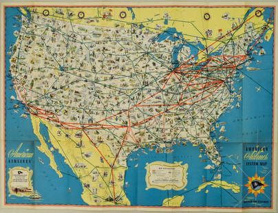
Sold20221940s American Airlines US Route Map -- American Airlines System MapTitle: 1940s American Airlines US Route Map -- American Airlines System Map Cartographer: American Airlines (General Drafting Co.) Year / Place: 1940s c. Map Dimension (in.): 24 X 32 in. Ths is an attSee Sold Price
Sold20201946 Greyhound US Route Map -- Map of Greyhound LinesTitle/Content of Map: 1946 Greyhound US Route Map -- Map of Greyhound Lines and Principal Connecting Lines Cartographer: Greyhound Year/Place: 1946 c. Size: 15 X 21.5 in. unfolded This is a nice foldiSee Sold Price
Sold20221946 Greyhound US Route Map -- Map of Greyhound Lines and Princial Connecting LinesTitle: 1946 Greyhound US Route Map -- Map of Greyhound Lines and Princial Connecting Lines Cartographer: Greyhound Year / Place: 1946 c. Map Dimension (in.): 15 X 21.5 in. unfolded This is a nice foldSee Sold Price
Sold20191946 Greyhound US Route Map -- Map of Greyhound LinesTitle/Content of Map: 1946 Greyhound US Route Map -- Map of Greyhound Lines and Princial Connecting Lines Date: 1946Cartographer: Greyhound Size: 15 X 21.5 in. unfolded This is a nice folding map showSee Sold Price
Sold2017National Geographic Map of Southwestern US Map, 1940The Southwestern United States map in the National Geographic Magazine dated June 1940. Measurement approximate: 26” x 35”. Condition: Very Good No Reserve: This lot starts at $1 and has no reservSee Sold Price
Sold2019United StatesReserve Reduced! Title: United States Publication Date: 1836 Cartographer: FINDLAY, ALEX. Publisher: KELLY, THOMAS Size (inches): H7.5 - W9.5 Map detailing the U.S. west to "Konzas Ville". Excellent dSee Sold Price
1 day LeftJasper521861 Map of Western US -- Reduced Section of a General Map of North America, Drawn from the Best$40
Jun 23Schilb Antiquarian Rare Books1877 Geology Geography Surveys 1ed Nevada Wyoming Utah George Wheeler US West 2v$1
5 days LeftMynt Auctions1940 Penn State Nittany Lions vs West Virginia College Football Program 137533$10
2 days LeftJasper52WEST AFRICA Explorers' routes Senegal Ashanti. Mountains of Kong. SDUK 1857 map$30
2 days LeftJasper52WEST AFRICA explorers' routes. Beaufort Gray Park Dochard Caillie. SDUK 1874 map$40
2 days LeftJasper52NIGERIA explorers' routes. Lander Clapperton Oudney Denham Allen. SDUK 1874 map$60
2 days LeftJasper52WEST AFRICA I Explorers' routes Senegal Ashanti Ivory Gold Coast. SDUK 1851 map$40
2 days LeftJasper52WESTERN AFRICA.Kong Mountains.Caravan routes.Slave Coast.TALLIS/RAPKIN 1851 map$55
2 days LeftJasper52WESTERN AFRICA.Kong Mountains.Caravan routes.Slave Coast.TALLIS/RAPKIN 1849 map$40
2 days LeftJasper52NORTHERN AFRICA. Morocco Tunisia Algeria. Caravan routes.TALLIS/RAPKIN 1851 map$45
2 days LeftJasper52NORTHERN AFRICA. Morocco Tunisia Algeria. Caravan routes. RAPKIN/TALLIS 1851 map$45
2 days LeftJasper52NORTHERN AFRICA. Morocco Tunisia Algeria. Caravan routes. RAPKIN/TALLIS 1851 map$45
2 days LeftJasper52NIGERIA w/ early explorers' routes. Lake Chad Yariba Houssa Borgou.SDUK 1844 map$60
2 days LeftJasper52WEST AFRICA II. NIGERIA. Bight of Benin-Lake Chad. Yariba Houssa. SDUK 1851 map$70