Sold20211864 Johnson Map of Evolving US West -- Johnson'sTitle: 1864 Johnson Map of Evolving US West -- Johnson's California, with Utah, Nevada, Colorado, New Mexico, and Arizona Cartographer: Johnson & Ward Year / Place: 1864, New York Map Dimension (in.):See Sold Price
Sold20231864 Johnson Map of US South West -- Johnson's California, with Territories of Utah, Nevada,Title: 1864 Johnson Map of US South West -- Johnson's California, with Territories of Utah, Nevada, Colorado, New Mexico, and Arizona Cartographer: Johnson & Ward Year/Place: 1864 New York Dimensions:See Sold Price
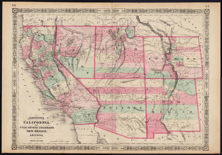
Sold2022Scarce Johnson map of the Great Western states, 1864Antique map of California, Nevada, Utah, Colorado, New Mexico, and Arizona. Published during a great time of expansion and change in the U.S. West, as well as during the Civil War. Here Utah displaysSee Sold Price
Sold20241863 Johnson Map of US West -- Johnson's California Territories of New Mexico Arizona ColoradoTitle: 1863 Johnson Map of US West -- Johnson's California Territories of New Mexico Arizona Colorado Nevada and Utah Cartographer: Johnson & Ward Year / Place: 1863, New York Map Dimension (in.): 17.See Sold Price
Sold20231863 Johnson Map of US West -- Johnson's California Territories of New Mexico Arizona ColoradoTitle: 1863 Johnson Map of US West -- Johnson's California Territories of New Mexico Arizona Colorado Nevada and Utah Cartographer: Johnson & Ward Year / Place: 1863, New York Map Dimension (in.): 17.See Sold Price
Sold2019Two Maps by Johnson & Ward, "West Indies," 1864, handTwo Maps by Johnson & Ward, "West Indies," 1864, hand colored, H.- 17 7/8 in., W.- 26 1/2 in.; together with "South America," 1860, hand colored, H.- 26 1/2 in., W.- 18 1/4 in. (2 Pcs.)See Sold Price
Sold2021Johnson map of American West – great color, 1864Authentic vintage maps of the American West—especially during the years of constant boundary change--are extremely collectible. Exceptional examples with great color and crisp ink impressions arSee Sold Price
Sold2022Significant United States map, 1864 Johnson & WardVery interesting hand-colored map created at a pivotal time in the settlement of the American West. In this lovely Civil War era map many of the western states have still not settled their borders. ArSee Sold Price
Sold20171863 Johnson’s Nebraska, Dakota, Colorado, Idaho Map1864 Johnson’s Nebraska, Dakota, Colorado, Idaho, Kansas. Johnson & Ward. Johnson and Ward's rare 1863 map of the territories of Idaho, Dakota, Nebraska, Colorado and Kansas. Extends west as far asSee Sold Price
Sold20231864 Johnson Map of Texas -- Johnson's New Map of the State of TexasTitle: 1864 Johnson Map of Texas -- Johnson's New Map of the State of Texas Cartographer: Johnson & Ward Year / Place: 1864, New York Map Dimension (in.): 16.7 X 24.5 in. Thisis a double page, superbSee Sold Price
Sold20201864 Johnson Map of Michigan and Wisconsin -- Johnson'sTitle/Content of Map: 1864 Johnson Map of Michigan and Wisconsin -- Johnson's Michigan and Wisconsin Cartographer: Johnson & Ward Year/Place: 1864, New York Size: 17 X 23 in. This is a large and highlSee Sold Price
Sold20221864 Johnson Map of Nebraska, Dakotas, Idaho and KansasTitle: 1864 Johnson Map of Nebraska, Dakotas, Idaho and Kansas -- Johnson's Nebraska, Dakota, Colorado, Idaho, Kansas Cartographer: Johnson & Ward Year / Place: 1864, New York Map Dimension (in.): 12.See Sold Price
Sold20181864 Johnson Map of North and South Carolina --Title/Content of Map: 1864 Johnson Map of North and South Carolina -- Johnson's North and South Carolina Date Printed: 1864, New York Cartographer: Johnson & Ward Size: 17.3 x 24 in. An excellent, larSee Sold Price
Sold20181864 Johnson Map of the United States -- Johnson'sTitle/Content of Map: 1864 Johnson Map of the United States -- Johnson's United States Date: 1864, New York Cartographer: A Johnson Size: 16.9 x 23.1 in. This is a large, highly detailed Civil War eraSee Sold Price
Sold20191864 Johnson Map of Texas -- Johnson's New Map of theTitle/Content of Map: 1864 Johnson Map of Texas -- Johnson's New Map of the State of Texas Date: 1864, New York Cartographer: Johnson & Ward Size: 16.7 X 24.5 in. This a double page, large, quite attrSee Sold Price
Sold20221864 Johnson Map of Florida -- Johnson's FloridaTitle: 1864 Johnson Map of Florida -- Johnson's Florida Cartographer: Johnson & Ward Year/Place: 1864, New York Dimensions: 12.6 X 15.5 in. Description: This is an excellent map of Florida. The majoriSee Sold Price
Sold20191864 Johnson Map of North and South Carolina --Title/Content of Map: 1864 Johnson Map of North and South Carolina -- Johnson's North and South Carolina Date: 1864, New York Cartographer: Johnson & WardSize: 17.3 x 24 in. An excellent, large, doublSee Sold Price
Sold20231864 Johnson Map of Dakota Territory and Minnesota -- Johnson's Minnesota and DakotaTitle: 1864 Johnson Map of Dakota Territory and Minnesota -- Johnson's Minnesota and Dakota Cartographer: Johnson & Ward Year / Place: 1864, New York Map Dimension (in.): 12.5 x 15.9 in. This is a verSee Sold Price
Sold20181864 Johnson Map of North and South Carolina --Title/Content of Map: 1864 Johnson Map of North and South Carolina -- Johnson's North and South Carolina Date Printed: 1864, New York Cartographer: Johnson & Ward Size: 17.3 x 24 in. An excellent, larSee Sold Price
Sold20211864 Johnson Map of Arkansas, Mississippi and LouisianaTitle: 1864 Johnson Map of Arkansas, Mississippi and Louisiana -- Johnson's Arkansas, Mississippi and Louisiana Cartographer: Johnson and Ward Year / Place: 1864, New York Map Dimension (in.): 17 X 24See Sold Price
Sold20181864 Johnson Map of Dakota Territory and MinnesotaTitle/Content of Map: 1864 Johnson Map of Dakota Territory and Minnesota -- Johnson's Minnesota and Dakota Date Printed: 1864, New York Cartographer: Johnson & Ward Size: 12.5 x 15.6 in. This is an inSee Sold Price
Sold20191864 Johnson Map of the Roman Empire -- Johnson's RomanTitle/Content of Map: 1864 Johnson Map of the Roman Empire -- Johnson's Roman Empire, Imperium Romanorum Latissime Patens Date: 1864, New York Cartographer: Johnson & Ward Size: 13 X 20.7 in. This isSee Sold Price
Sold20221864 Johnson Map of Maine -- Johnson's MaineTitle: 1864 Johnson Map of Maine -- Johnson's Maine Cartographer: Johnson & Ward Year/Place: 1864, New York Dimensions: 15.9 X 12.5 in. Description: This is an excellent map of Maine. Plenty of detailSee Sold Price
Sold20181864 Johnson Map of Pennsylvania and New Jersey --Title/Content of Map: 1864 Johnson Map of Pennsylvania and New Jersey -- Johnson's Pennsylvania and New Jersey Date: 1864, New York Cartographer: Johnson & Ward Size: 17.1 x 23.2 in. A nice, double paSee Sold Price
3 hrs LeftJasper521864 Johnson Map of Massachusetts, Connecticut and Rhode Island -- Johnson's Massachusetts,$60
May 21Jasper521878 Mitchell Map of Washington, Oregon, Idaho, much of Montana [verso] Territory of Idaho$55
1 day LeftJasper52North-west Europe. Nordic Countries. British Isles Scandinavia. THOMSON 1830 map$100
1 day LeftJasper52North-west Europe. Nordic Countries. British Isles Scandinavia. THOMSON 1817 map$120
1 day LeftJasper52Corso del Danubio da Belgrado fino al Mar Ner. Danube. ROSSI / CANTELLI 1684 map$160
Featured1 day LeftJasper52Hyperboreorum/Septentrionalum regionum. Bertius/Langenes. Europe Arctic 1603 map$420
3 hrs LeftJasper521865 Johnson Map of Arkansas, Mississippi and Louisiana -- Johnson's Arkansas, Mississippi and$60
May 21Jasper521866 Johnson Map of Sweden, Norway and Denmark -- Johnson's Sweden, Norway [on sheet with] Denmark$40
May 21Jasper521866 Johnson's Map of France, Spain, Portugal -- Johnson's France, Spain and Portugal$45
May 21Jasper521866 Johnson's Map of Hungary, Austria, Greece and Turkey in Europe -- Johnson's Austria, Turkey in$60


![1878 Mitchell Map of Washington, Oregon, Idaho, much of Montana [verso] Territory of Idaho (1 of 2)](https://p1.liveauctioneers.com/5584/329422/177662232_1_x.jpg?height=282&quality=70&version=1715717898)


![1866 Johnson Map of Sweden, Norway and Denmark -- Johnson's Sweden, Norway [on sheet with] Denmark (1 of 1)](https://p1.liveauctioneers.com/5584/329422/177662257_1_x.jpg?height=282&quality=70&version=1715717898)


