Sold2021Johnson map of American West – great color, 1864Authentic vintage maps of the American West—especially during the years of constant boundary change--are extremely collectible. Exceptional examples with great color and crisp ink impressions arSee Sold Price
Sold2022Significant United States map, 1864 Johnson & WardVery interesting hand-colored map created at a pivotal time in the settlement of the American West. In this lovely Civil War era map many of the western states have still not settled their borders. ArSee Sold Price
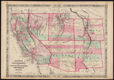
Sold2022Scarce Johnson map of the Great Western states, 1864Antique map of California, Nevada, Utah, Colorado, New Mexico, and Arizona. Published during a great time of expansion and change in the U.S. West, as well as during the Civil War. Here Utah displaysSee Sold Price
Sold2023Scarce Johnson map of the Great Western states, 1864Authentic vintage map of California, Utah, Nevada, Colorado, New Mexico, and Arizona. Created during a great time of expansion and change in the western United States while the Civil War was still ragSee Sold Price
Sold2019Two Maps by Johnson & Ward, "West Indies," 1864, handTwo Maps by Johnson & Ward, "West Indies," 1864, hand colored, H.- 17 7/8 in., W.- 26 1/2 in.; together with "South America," 1860, hand colored, H.- 26 1/2 in., W.- 18 1/4 in. (2 Pcs.)See Sold Price
Sold2017Johnson: Map of Washington & Oregon, 1862Map: Johnson’s Washington and Oregon Maker: Johnson & Ward Date: 1862 Size: 12.5 x 15.5 inches Condition: Beautiful map with great color, good print and wide margins. Couple of tiny margin spots. HaSee Sold Price
Sold20211864 Johnson Map of Evolving US West -- Johnson'sTitle: 1864 Johnson Map of Evolving US West -- Johnson's California, with Utah, Nevada, Colorado, New Mexico, and Arizona Cartographer: Johnson & Ward Year / Place: 1864, New York Map Dimension (in.):See Sold Price
Sold20231864 Johnson Map of US South West -- Johnson's California, with Territories of Utah, Nevada,Title: 1864 Johnson Map of US South West -- Johnson's California, with Territories of Utah, Nevada, Colorado, New Mexico, and Arizona Cartographer: Johnson & Ward Year/Place: 1864 New York Dimensions:See Sold Price
Sold2024South West American Indian CarpetLot Consists of an American South West Indian Carpet. Made of Wool, Good Color. No Great Wear. Approximate Size is 2' Feet by 4' FeetSee Sold Price
Sold2022Map of entire Western States, Steinwehr 1870Nice map depicts the entire American West from top to bottom of the country. Shows railroads, topography, rivers, forts, towns. Printed color. Map by A. von Steinwehr in 1870 atlas published by WilsonSee Sold Price
Sold2018Johnson Map of TexasNew Map of the State of Texas. Steel engraving with original hand color. New York, Johnson & Ward, 1864. 17 1/2 inches x 25 1/2 inches sheet, 26 1/2 x 37 inches framed Beautiful map of Texas printed dSee Sold Price
Sold20191863 Johnson Map of Mexico -- Johnson's MexicoTitle/Content of Map: 1863 Johnson Map of Mexico -- Johnson's Mexico Date: 1863, New York Cartographer: A Johnson Size: 12.5 x 15.5 in. Very nice map of Mexico, color-coding the states. Great deal ofSee Sold Price
Sold2016ALVIN JEWETT JOHNSON (AMERICAN, 1827-1884) MAP OFALVIN JEWETT JOHNSON (AMERICAN, 1827-1884) MAP OF VIRGINIA, DELAWARE, MARYLAND, AND WEST VIRGINIA, hand-colored lithograph on paper, custom matted and housed under glass in a modern frame. Circa 1864-See Sold Price
Sold2021Scarce 1847 map of Western Terr. Of the U. S.Title: Scarce 1847 map of Western Terr. Of the U. S. Description: Great and uncommon map showing the transitional boundaries of the American West c1840s. massive Oregon Territory, encompassing futureSee Sold Price
Sold2018France, Holland and BelgiumMap: France, Holland and Belgium Date: 1862 Cartographer: Johnson and Browning Material: paper Dimensions: 26.75"wide x 18"high Great color, insets of Corsica, Amsterdam and Brussels. The 1862 ribbonSee Sold Price
Sold2017Burgess: Antique Map of the United States & Canada 1853Map of the United States and Canada, Burgess 1853. Great map of the U. S. during the transitional period of the American West. Most of the western lands are shown as large territories: Minnesota, NebrSee Sold Price
Sold20201852 1ed Great Salt Lake Utah Stansbury Exploration Mor1852 1ed Great Salt Lake Utah Stansbury Exploration Mormon Polygamy Indians Maps Howard Stansbury was a 19th-century engineer and explorer known for his ventures to the American west. In 1849, he wasSee Sold Price
Sold2017Johnson: Antique Map of Florida, 1864Map: 1864 Johnson Map of Florida -- Johnson's Florida Cartographer: A Johnson Year / Place: 1864, New York City Map Dimensions: 12 x 15.3 in. Condition: Very Good. Vivid colors. Slight age toning throSee Sold Price
Sold2022Western Travel notices 1800's: GN, C&GN, CB&Q4 advertising pieces of paper from the American West. All are 1800s and none are dated. Great Northern cardstock card with map and immigration info, MoPac - folding "Settlers" Excursion schedules andSee Sold Price
Sold2020Thompkins Wild West PosterAction packed wild west show poster with great Native American graphics, and vibrant colors. Professionally framed, sight measuring 18 1/2" x 28 1/2".See Sold Price
Sold2016World Map of Ocean Currents & Air Temperatures, 1867Original engraving from "New Illustrated Family Atlas of the World" published by A.J. Johnson, 1867. Wonderful original color. Great detail showing ocean currents and river basins of the world on uppeSee Sold Price
Sold2022Authentic large-format 1864 map of Palestine, Johnson &Scarce and informative hand-colored map of Palestine with inset of Jerusalem. If you’ve ever wanted to understand about locations mentioned in the Bible, this would be a great map for you. CreaSee Sold Price
Sold20171855 map of Virginia by G. W. ColtonItem: 1855 map of Virginia by G. W. Colton Description: Great hand color and clean. Virginia before West Virginia became a separate state. Insets of Richmond and Norfolk. From the 1856 edition of ColtSee Sold Price
Sold20201884 HOLY BIBLE Clamshell VICTORIAN American MAPS Rare1884 HOLY BIBLE Clamshell Victorian American Maps Leather ANTIQUE Sunday School The Holy Bible, Containing the Old and New Testaments, Etc. Great Victorian era clamshell-bound leather Bible with colorSee Sold Price
Featured5 days LeftJasper521864 Johnson Map of Michigan and Wisconsin -- Johnson's Michigan and Wisconsin$85
7 days LeftHolabird Western Americana CollectionsEarly West Surveys, Photography, 1962 & '75 [182053]$50
2 days LeftTrillium Antique Prints & Rare BooksKarl Bodmer - "Dog Dance"; P?hriska-R?hpa. Moennitarri Warrior in the Costume of the Dog Danse$425(2 bids)
Jun 07Freeman's | HindmanHOMANN, Johann Baptist. Amplissimae Regionis Mississipi Seu Provinciae Ludovicianae. Nuremburg, [ca$400(1 bid)


![Across America, Rusling, 1875 [181941] (1 of 0)](https://p1.liveauctioneers.com/dist/images/placeholder.jpg?height=282&quality=70)
![French Map of America Southeast [179304] (1 of 1)](https://p1.liveauctioneers.com/2699/331495/178785746_1_x.jpg?height=282&quality=70&version=1717094933)

![Early West Surveys, Photography, 1962 & '75 [182053] (1 of 9)](https://p1.liveauctioneers.com/2699/331494/178785471_1_x.jpg?height=282&quality=70&version=1717094654)


