Sold20201861 Map of MaineAuthor: Johnson Title: 1861 Map of Maine Medium: Ink on Paper Dimensions: 14.5"X18" Map of Maine dated 1861. Engraved by A.J.Johnson. Published by Johnson and Ward in New York. Map key located lower rSee Sold Price
Sold2017Colton: Antique Map of Maine, 1861Title/Content of Map: Colton's Maine Date Printed: 1861 Cartographer: J.H. Colton Material/Medium: Paper Size: 14" x 17" Hand colored, steel engraved. From 'Colton's General Atlas. Published in New YoSee Sold Price
Sold20211861 MAP OF COAST OF SOUTH CAROLINAOriginal 1861 Frank Leslies Illustrated News Coast of South Carolina Wood Engraving with later hand coloring. Professionally framed. In frame measures 28"x31"x1". Weight 9 pds. NO IN HOUSE SHIPPING. PSee Sold Price
Sold20231861 Map of the United StatesAn oversize hanging map of the United States printed in Washington DC and dated 1861 showing the state boundaries, major cities and geographic features. These maps were used particularly in the earlySee Sold Price
Sold2018Large/scarce 1861 map of New York BayReserve Reduced! Large and scarce 1861 coastal map of New York City and its harbor. One of the earliest 19th century charts to depict New York City as we know it today. It shows Manhattan, Brooklyn anSee Sold Price
Sold2024Johnson's South America. Bolivia with Littoral. Navigators' routes 1861 mapCAPTION PRINTED BELOW PICTURE: 'Johnson's South America' DATE PRINTED: 1861 IMAGE SIZE: Approx 65.5 x 45.5cm, 25.75 x 18 inches (Large); Please note that this is a folding map. TYPE: Large, decorativeSee Sold Price
Sold2023Johnson's Brazil, Argentine Republic, Paraguay & Uruguay. South America 1861 mapTitle: Johnson's Brazil, Argentine Republic, Paraguay & Uruguay. South America 1861 map Description: Johnson's Brazil, Argentine Republic, Paraguay and Uruguay' by Alvin Jewett Johnson (1861). Large,See Sold Price
Sold2019MAPS - Maine. U.S. Gov.Maine. U.S. Gov., [Lot of 2] Map of the Northern Part of the State of Maine and of the Adjacent British Provinces... [and] Extract from a Map of the British and French Dominions in North America, 1838See Sold Price
Sold2023Johnson's Central America. Guatemala Honduras Nicaragua Costa Rica 1861 mapTitle: Johnson's Central America. Guatemala Honduras Nicaragua Costa Rica 1861 map Description: Johnson's Central America // Isthmus of Panama // Harbor of San Juan de Nicaragua // The "Nicaragua RoutSee Sold Price
Sold2023Johnson's Cuba, Jamaica & Porto Rico. Puerto Rico. Bahamas Florida Keys 1861 mapTitle: Johnson's Cuba, Jamaica & Porto Rico. Puerto Rico. Bahamas Florida Keys 1861 map Description: Johnson's Cuba, Jamaica and Porto Rico' by Alvin Jewett Johnson (1861). Large, decorative hand coloSee Sold Price
Sold20171861 Map of Kansas, Nebraska & Colorado, Mitchell, Jr1861 Map of Kansas, Nebraska and Colorado, showing also the southern portion of Dacotah. S Augustus Mitchell, Jr. 11.5 x 14.5 inches. A beautiful example of S. A. Mitchell Junior's 1866 map of KanSee Sold Price
Sold20221861 Map of Western US -- Reduced Section of NorthTitle: 1861 Map of Western US -- Reduced Section of North America Including all the Recent Geographical Discoveries Cartographer: US Government - Senate Date/Place: 1861, Washington Dimensions: 7.1 XSee Sold Price
Sold20231861 Map of Kentucky & Tennessee. By Johnson and BrowningTitle: 1861 Map of Kentucky & Tennessee. By Johnson and Browning Date/Period: 1861 Materials: Steel engraved Size: 26 x 18” 1861, by Johnson and Browning. From ‘New Illustrated Family AtlaSee Sold Price
Sold2024Johnson's Asia. Bod or Tibet. Toorkistan Cabool Birmah Persia Corea 1861 mapCAPTION PRINTED BELOW PICTURE: 'Johnson's Asia' DATE PRINTED: 1861 IMAGE SIZE: Approx 33.5 x 41.5cm, 13.25 x 16.25 inches (Large) TYPE: Large, decorative hand coloured 19th century atlas map CONDITIONSee Sold Price
Sold20211861 Map of GermanyAuthor: Johnson Title: 1861 Map of Germany Medium: Ink on Paper Dimensions: 18"X13.5" Map of Germany dated 1861. Engraved by A.J. Johnson dated 1861. Published by Johnson and Ward in New York. CaptureSee Sold Price
Sold20231861 Map of Italy by Johnson and BrowningTitle: 1861 Map of Italy by Johnson and Browning Date/Period: 1861 Materials: Steel engraved Size: 26 x 18” This 1861 map by Johnson and Browning depicts Italy, soon to be unified, in two partsSee Sold Price
Sold20231861 Map of New Jersey. By Johnson and BrowningTitle: 1861 Map of New Jersey. By Johnson and Browning Date/Period: 1861 Materials: Steel engraved Size: 18x13” 1861, by Johnson and Browning. From ‘New Illustrated Family Atlas, with DescSee Sold Price
Sold20231861 Map of Illinois, by Johnson and BrowningTitle: 1861 Map of Illinois, by Johnson and Browning Date/Period: 1861 Materials: Steel engraved Size: 18x13” With an image of Chicago’s court house. 1861, by Johnson and Browning. From &#See Sold Price
Sold20241861 Map of Iowa and Eastern Nebraska. By Johnson and BrowningTitle: 1861 Map of Iowa and Eastern Nebraska. By Johnson and Browning Date/Period: 1861 Materials: Steel engraved Size: 18x13” 1861, by Johnson and Browning. From ‘New Illustrated Family ASee Sold Price
20231861 Map of Lower and Upper Canada. By Johnson and BrowningTitle: 1861 Map of Lower and Upper Canada. By Johnson and Browning Date/Period: 1861 Materials: Steel engravedSize: 26 x 18” 1861, by Johnson and Browning. From ‘New Illustrated Family AtlSee Sold Price
Sold2022[MANUSCRIPT MAP-MAINE] CHADWICK, JOSEPH. Plan of part of the lands belonging to the Heirs of Brigd.r[MANUSCRIPT MAP-MAINE] CHADWICK, JOSEPH. Plan of part of the lands belonging to the Heirs of Brigd.r Waldo ... measured by Joseph Chadwick Nov.r 1765. [New England]: November, 1765. Manuscript surveySee Sold Price
Sold2022[MANUSCRIPT MAP-MAINE] After DES BARRES, JOSEPH FREDERICK WALLET. Hand-drawn map of a portion of the[MANUSCRIPT MAP-MAINE] After DES BARRES, JOSEPH FREDERICK WALLET. Hand-drawn map of a portion of the Maine coast off Falmouth, copied from Des Barres. Likely early 19th century. Manuscript map in blacSee Sold Price
Sold2016Coast of South Carolina (Great Naval Expedition), 1861Original wood engraving from Frank Leslie's Illustrated Newspaper, November 23, 1861. Map is of Port Royal and naval & military operations of the Great Naval Expedition of Commodor DuPont & General ShSee Sold Price
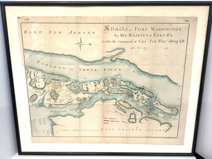
Sold2021Map Of Attacks Of Fort Washington 16th, November 1776.D.T. Valentine's Manual Of 1861, Map Of Attacks Of Fort Washington by His Majesty's forces under the command of General Sir Will Howe K.B. 16th of November 1776 (Revolutionary War) .. Hand colored. MaSee Sold Price
12 hrs LeftJasper521861 Map of Western US -- Reduced Section of a General Map of North America, Drawn from the Best$40
Featured1 day LeftJasper52Afrique…Nord-Ouest' & 'Inde' by Meissas. N Africa India Singapore 1861 old map$20
Jun 13Swann Auction Galleries(MAINE.) J.H. Colton; and C.C. Hall. Railroad & Township Map of the State of Maine with Portions$375
12 hrs LeftJasper521893 Civil War Map Washington, Paducah, KY and Logan's Cross-Roads plus Mill Springs, KY -- Defenses$70
Jun 13Swann Auction Galleries(AMERICAN NORTHEAST.) Nicolas Visscher. Nova Tabula Geographica Complectens Borealiorem Americae$1,100


![MAPS - Maine. U.S. Gov.: Maine. U.S. Gov., [Lot of 2] Map of the Northern Part of the State of Maine and of the Adjacent British Provinces... [and] Extract from a Map of the British and French Dominions in North America, 1838](https://p1.liveauctioneers.com/6576/142214/71976779_1_x.jpg?height=310&quality=70&version=1557929467)


![[MANUSCRIPT MAP-MAINE] CHADWICK, JOSEPH. Plan of part of the lands belonging to the Heirs of Brigd.r: [MANUSCRIPT MAP-MAINE] CHADWICK, JOSEPH. Plan of part of the lands belonging to the Heirs of Brigd.r Waldo ... measured by Joseph Chadwick Nov.r 1765. [New England]: November, 1765. Manuscript survey](https://p1.liveauctioneers.com/292/250642/130213647_1_x.jpg?height=310&quality=70&version=1654271664)
![[MANUSCRIPT MAP-MAINE] After DES BARRES, JOSEPH FREDERICK WALLET. Hand-drawn map of a portion of the: [MANUSCRIPT MAP-MAINE] After DES BARRES, JOSEPH FREDERICK WALLET. Hand-drawn map of a portion of the Maine coast off Falmouth, copied from Des Barres. Likely early 19th century. Manuscript map in blac](https://p1.liveauctioneers.com/292/250642/130213649_1_x.jpg?height=310&quality=70&version=1654271664)


![Maine Map, 1840 [181582] (1 of 1)](https://p1.liveauctioneers.com/2699/331495/178785758_1_x.jpg?height=282&quality=70&version=1717094933)


![French Map of America Southeast [179304] (1 of 1)](https://p1.liveauctioneers.com/2699/331495/178785746_1_x.jpg?height=282&quality=70&version=1717094933)


![Campaigns in the West 1856-1861 [181529] (1 of 6)](https://p1.liveauctioneers.com/2699/331494/178785466_1_x.jpg?height=282&quality=70&version=1717094654)

