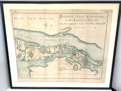
Sold2021Map Of Attacks Of Fort Washington 16th, November 1776.D.T. Valentine's Manual Of 1861, Map Of Attacks Of Fort Washington by His Majesty's forces under the command of General Sir Will Howe K.B. 16th of November 1776 (Revolutionary War) .. Hand colored. MaSee Sold Price
Sold2022A Plan of Charles Town the Capital of South Carolina… Charleston. LODGE 1780 mapTITLE/CONTENT OF MAP: 'A Plan of Charles Town the Capital of South Carolina, with the Harbour, Islands and Forts; the Attack on Fort Sulivan, by His Majesty's Ships under Sir Peter Parker, in 1776; thSee Sold Price
Sold2016Map of New York City & Plan of Fort Washington (PortEngraved by George Hayward for D.T. Valentine's Manual. Map features northern Manhattan with Revolutionary War battles and troop movements, hightlighted by number on right side of map. The full titleSee Sold Price
Sold20221776 Mobile Famous “Flying Camp” of Pennsylvania Prisoner of War Survivor Taken at Fort1776 Mobile Famous “Flying Camp” of Pennsylvania Prisoner of War Survivor Taken at Fort Washington [REVOLUTIONARY WAR.] Manuscript Document Signed, Account of the United States with RobertSee Sold Price
Sold2022Faden Map of the Plan of the Attack of the Forts Clinton & Montgomery with beautiful original handFADEN, William (1749-1836). Plan of the Attack of the Forts Clinton & Montgomery upon Hudsons River which were Stormed by His Majesty's Forces under the Command of Sir Henry Clinton, 6th of Octr. 1777See Sold Price
Sold2021A Flemish Verdure Tapestry Fragment, Late 16th/earlyA Flemish Verdure Tapestry Fragment Late 16th/early 17th century The borders cut. 6 ft. 4 in. x 8 ft. 4 in. PROVENANCE: Private Collection, Fort Washington, Pennsylvania.See Sold Price
Sold2022Subdividing the Castro District in S.F.Heading: -1864 Author: Eureka Homestead Association Title: Copy of the official map of the property of the Eureka Homestead Association, adopted November 16th, 1864 Place Published: San Francisco PublSee Sold Price
Sold2022Eureka Homestead in the Castro District, 1864Heading: -1864 Author: Eureka Homestead Association Title: Copy of the official map of the property of the Eureka Homestead Association, adopted November 16th, 1864 Place Published: San Francisco PublSee Sold Price
Sold2023MAP: MOUNT SCOTT - FORT SILL, OKLAHOMA/ COMANCHE COUNTY 1949Description: MOUNT SCOTT - FORT SILL, OKLAHOMA/ COMANCHE COUNTY 1949. Prepared by the army map Army Map Service (AM), Corps of Engineers, US Army, Washington D.C. Compiled in 1949.Material: PaperMeasuSee Sold Price
Sold2019In Camp & Battle with Washington ArtilleryIn Camp and Battle with the Washington Artillery of New Orleans A narrative of events during the Late Civil War from Bull Run to Appomattox and Spanish Fort. IlSee Sold Price
Sold2021Map of WashingtonPublication Date: 1882 Title: Map of Washington Cartographer: HARDESTY Publisher: RAND, MCNALLY & CO. Map showing towns, townships, forts, missions, topography, roads, railroads, proposed N. Pac. RR,See Sold Price
Sold2020Large cast iron Jocko Graves hitching postThis is a copy of historic lawn jockey going back to the Revolutionary War. On the night of December 25-26, 1776, when George Washington and his army crossed to Delaware to make a surprise attack on tSee Sold Price
Sold2022Scarce Amer. Rev. War map showing Manhattan, Marshall/Yeager 1832Scarce Revolutionary War battle plan of the New York Campaign of 1776, from Marshall's Life of Washington. Shows the American positions on Manhattan Island. Covers the strategically important ManhattaSee Sold Price
Sold20201892 Cowles Civil War Map of Battles in SoutheasternTitle: 1892 Cowles Civil War Map of Battles in Southeastern Virginia -- Military Department of Southeastern Virginia and Fort Monroe, 1861 [Plate XVI] Date: 1892, Washington Cartographer: C Cowles (coSee Sold Price
Sold2016Map, Hudson River, Rev. War, Sauthier, 1776At the top of the map is written: "A Topographical Map of Hudsons River, with the Channels Depth of Water, Rocks, Shoals, &c. and the Country Adjacent, from Sandy-Hook, New York and Bay to Fort EdwardSee Sold Price
Sold2015Map for the Plan of the City of Washington. c.1799A map for the "Plan of the City of Washington". In the lower margin: “Published by J. Stockdale, Picadilly 16th Sepr. 1798.” The map appeared in Isaac Weld’s “Travels through the States of NorSee Sold Price
Sold20231776 Map of Country Round Philadelphia New Jerseypublished for Gentlemans Magazine, London, 1776, copper plate engraving on laid paper, sight 9 x 7.5 in.. good condition, folds lines, light foxing, not examined out of frame..Washington Square GallerSee Sold Price
Sold2016A Platinum & Diamond Cocktail Ring, Cartier, c.1946Auction announcements 16th November 2016 Lot 17: The correct starting price is 3,600 €. An Exquisite Platinum & Diamond Cocktail Ring, by Cartier, London, circa 1946 Designed as a pair of stylised tSee Sold Price
Sold2022Pr. of Important NH Revolutionary War Muster RollsTwo Revolutionary War muster rolls, dated December 16th, 1776. Each enlisting soldiers from the Kingston, New Hampshire area, to serve in the American Army and fight in the Revolution under MustermastSee Sold Price
Sold2022(2) RARE REVOLUTIONARY WAR ERA PROCLAMATIONS FROM ROYALIST GOV. JONATHAN TRUMBULL OF CONNECTICUTSuspension of the General Council, April 4th, 1775 & Maj. General Schuyler Pardon to Deserters of the Continental Army, dated July 16th, 1776. The first is docketed with vote count and payroll of offiSee Sold Price
Sold2021A Pair of Gothic Revival Carved Walnut Hall Chairs,A Pair of Gothic Revival Carved Walnut Hall Chairs Late 19th/early 20th century H: 56, W: 25, D: 21 1/2 in. PROVENANCE: Private Collection, Fort Washington, Pennsylvania.See Sold Price
Sold2024Andy Warhol, Cow (FS II.12A)Andy Warhol(American, 1928 -1987)Cow (FS II.12A)screen-print in colors on wove wall paperCreated for the exhibition at the Modern Art Pavilion, Seattle Center, Seattle, Washington, November 18, 1976 -See Sold Price
Sold2017A Pair Of Antique Chinese Sang De Boeuf Vases AsLamps . From a Fort Washington NY estate . - Dimensions: Height: 12.5 InchesSee Sold Price
SoldHARRISON, WILLIAM HENRY. Autograph Document Signed, "Wm. H. Harrison,"HARRISON, WILLIAM HENRY. Autograph Document Signed, "Wm. H. Harrison," as Commandant of Fort Washington, ordering the Quartermaster General [John Wilkins, Jr.] to "issue for the use of a Public houseSee Sold Price
5 days LeftBlackstone Valley Auctions & Estates LLCRevolutionary Era War Map of the Attack on Ft. Moultrie.$225(3 bids)
2 days LeftJasper521861 Mitchell Map of Washington DC -- Plan of the City of Washington The Capitol of the United$70
2 days LeftJasper521880 Gray Map of Maryland, Delaware and Washington DC -- Maryland, Delaware and the District of$75
3 days LeftZikorn Arts & History ObjectsWest Indies, Eastern Cuba 1881 British Admiralty Nautical Map$100
3 days LeftZikorn Arts & History ObjectsWest Indies, Western Cuba 1879 British Admiralty Nautical Map$100
2 days LeftJasper52Bellin Map of St. Salvador, Brazil -- Plan de la ville de St. Salvador [with] Vue de la Ville de St.$55
2 days LeftJasper521896 Cram Comparison of Tall Buildings Globally -- Diagram of the Principal High Buildings of the$70
C & T Auctioneers and Valuers LtdA First / Second Day of the Battle of the Somme Killed in Action 1914-15 Star Medal to the Lancashir£32(2 bids)
Eaton and Brennan AuctionsQueen Group Signed Set of (3) Lloyds Bank And Coutts & Co London Checks (Tracks COA)$2,000(1 bid)
3 days LeftPotter & Potter AuctionsBraniff / Concorde. 1970s. Photographic airline poster adve...$150
3 days LeftPotter & Potter AuctionsPOLAND, Edwin Christian (1903 – 1991). The Evergreen Playgr...$200


![1776 Mobile Famous “Flying Camp” of Pennsylvania Prisoner of War Survivor Taken at Fort: 1776 Mobile Famous “Flying Camp” of Pennsylvania Prisoner of War Survivor Taken at Fort Washington [REVOLUTIONARY WAR.] Manuscript Document Signed, Account of the United States with Robert](https://p1.liveauctioneers.com/6306/260874/135867815_1_x.jpg?height=310&quality=70&version=1662577413)


![1892 Cowles Civil War Map of Battles in Southeastern: Title: 1892 Cowles Civil War Map of Battles in Southeastern Virginia -- Military Department of Southeastern Virginia and Fort Monroe, 1861 [Plate XVI] Date: 1892, Washington Cartographer: C Cowles (co](https://p1.liveauctioneers.com/5584/159675/80583510_1_x.jpg?height=310&quality=70&version=1579644740)


![HARRISON, WILLIAM HENRY. Autograph Document Signed, "Wm. H. Harrison,": HARRISON, WILLIAM HENRY. Autograph Document Signed, "Wm. H. Harrison," as Commandant of Fort Washington, ordering the Quartermaster General [John Wilkins, Jr.] to "issue for the use of a Public house](https://p1.liveauctioneers.com/199/320003/172142040_1_x.jpg?height=310&quality=70&version=1709067727)


![Bellin Map of St. Salvador, Brazil -- Plan de la ville de St. Salvador [with] Vue de la Ville de St. (1 of 1)](https://p1.liveauctioneers.com/5584/328338/176911634_1_x.jpg?height=282&quality=70&version=1715113718)


![[MAP]. ORTELIUS, Abraham. Turcici Imperii Descriptio.1592. (1 of 2)](https://p1.liveauctioneers.com/197/329395/177650538_1_x.jpg?height=282&quality=70&version=1715364962)